Positioning data redirection method and system

A positioning data and redirection technology, applied in satellite radio beacon positioning systems, digital data protection, geographic information databases, etc., can solve the problem of cloud mobile phones being unable to locate, and achieve high promotion and application value, stable system operation, and simple structure Effect

Active Publication Date: 2021-03-09
KYLIN CORP
View PDF9 Cites 0 Cited by
  • Summary
  • Abstract
  • Description
  • Claims
  • Application Information

AI Technical Summary

Problems solved by technology

[0007] The technical problem to be solved in the present invention is to provide a method and system for positioning data redirection, which can effectively solve the demand problem that cloud mobile phones cannot be located

Method used


Image

  • Positioning data redirection method and system
  • Positioning data redirection method and system

Examples


Embodiment Construction

[0038] The present invention will be described in further detail below in conjunction with the examples.

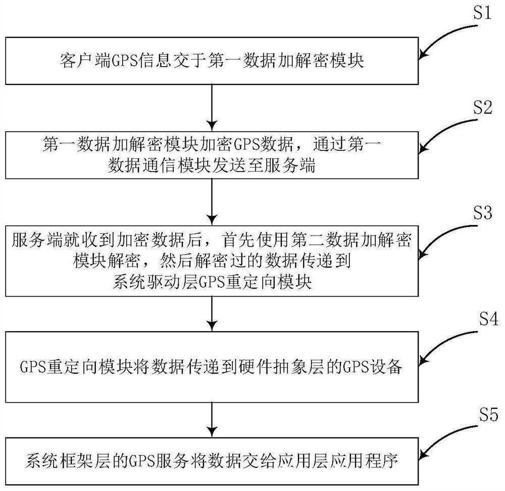
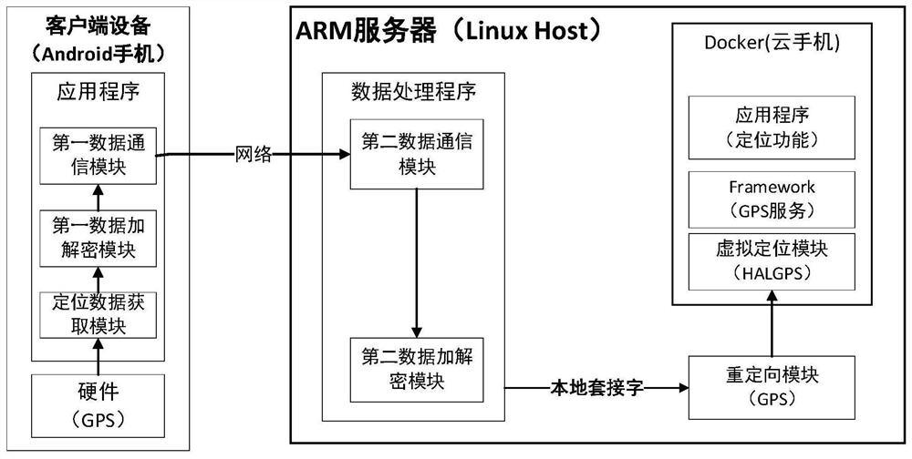
[0039] The invention discloses a method for positioning data redirection. A remote server is built based on virtualization technology, a virtual mobile phone is built in the remote server by container technology, and the hardware data of the client device (such as a sensor , GPS data) are mapped to the corresponding framework layer of the virtual mobile phone (for example, mapped to HAL, which is the hardware abstraction layer), so that the virtual mobile phone can realize the same positioning function as the client device and complete the redirection of positioning data.

[0040] The location data redirection process is clear, concise, and highly scalable. For example, the virtualization technology adopts ARM virtualization technology, and the corresponding remote server is an arm server. Of course, you can choose other virtualization technologies, such as KVM, dependin...


PUM


Abstract

The invention relates to a positioning data redirection method and system, and the system is divided into two parts: a first part provides data transmission from a client to a server, and comprises adata communication module, an encryption and decryption module, and a positioning data obtaining module; and a second part comprises a redirection module of the system driving layer and a virtual positioning module of the hardware abstraction layer. According to the invention, the positioning data of the user client equipment is mapped to the corresponding framework layer, such as a hardware abstraction layer, of the cloud mobile phone of the ARM server, so that the redirection of the positioning data is realized, and the problem that the cloud mobile phone of the ARM server lacks positioninghardware and cannot provide positioning service is solved.

Description

technical field [0001] This patent application belongs to the technical field of cloud mobile phone positioning, and more specifically relates to a method and system for redirecting positioning data. Background technique [0002] GPS (Global positioning system) is a navigation system developed by the U.S. military in the 1970s on the basis of the "meridian satellite navigation and positioning" technology. In terms of positioning, it is a satellite-based high-precision radio navigation positioning system that can provide accurate geographic location, speed and precise time information anywhere in the world and in near-earth space. The Beidou satellite navigation system is a satellite navigation system independently constructed and operated by China focusing on the needs of national security and economic and social development. It is an important national space that provides all-weather, all-day, high-precision positioning, navigation and timing services for global users infr...

Claims


Application Information

Patent Timeline
Patent Type & Authority Applications(China)
IPC IPC(8): G06F16/29G06F21/60G06F9/455G01S19/37
CPCG06F16/29G06F21/602G06F9/45558G01S19/37Y02D30/70
Inventor 张里阳吴春光赵奎张远航齐璇
Owner KYLIN CORP
Why Eureka
Try Eureka