
Excavator construction guiding system and construction method

A technology of guidance system and construction method, applied in the field of surveying, can solve the problems of occlusion of viewing angle, inconvenience, and many uncertain factors of environmental change, and achieve the effect of avoiding over-excavation and convenient maintenance.

Inactive Publication Date: 2021-01-26
广州三维可视化测绘科技有限公司
View PDF0 Cites 11 Cited by
  • Summary
  • Abstract
  • Description
  • Claims
  • Application Information

AI Technical Summary

Problems solved by technology

The existing excavator measurement system is generally two GNSS satellite receiving antennas installed on the car body, and the angle measuring sensor is directly installed on the car body, boom, stick, the rotating shaft of the car body and boom, the boom and stick On the rotating shaft, the rotating shaft of the arm and bucket, and the rocker of the bucket, the three-dimensional coordinates of the bucket teeth need to be estimated from the vehicle body to calculate the spatial position of the boom’s rotating shaft. Compared with directly measuring and calculating the pose of the boom, the accumulated measurement calculation Error, if the angle sensor chooses the inclination sensor, the dynamic measurement accuracy of the inclination sensor is required to be high, and the dynamic measurement accuracy of the inclination sensor is far worse than the static measurement accuracy, so the dynamic performance of the inclination sensor is required to be higher
[0003] The angle measuring sensor is installed on the rotating shaft and rocker of the bucket and arm, and its position needs to be close to the construction object. If the construction object is relatively hard, it will cause greater vibration during construction. Therefore, the angle measuring sensor is required to be highly resistant to vibration. The protection requirements for anti-falling and anti-collision are relatively high. If the construction is carried out underwater, the angle sensor will be completely soaked in water, and the waterproof requirements are high. When disassembling the bucket, it will be very difficult to disassemble the angle sensor It is inconvenient and difficult to use and maintain; the angle measuring sensor is installed on the stick, the boom and the shaft of the stick, and its position is relatively close to the construction object. When the construction object is relatively hard, the angle measuring sensor is also required to have a larger Excellent anti-vibration performance, good waterproof performance is also required in deep water construction. When disassembling the stick, it is inconvenient to disassemble and assemble the stick angle sensor, and it is difficult to use and maintain
[0004] The existing construction method of the excavator construction guidance system with visualization requires additional equipment to collect the actual terrain. When installing the equipment, it is also necessary to extend the bracket on the excavator to install the equipment to reduce blind spots. The installation of the equipment is troublesome, but it is still unavoidable The angle of view is sometimes blocked by the bucket, and the terrain data at the bucket teeth cannot be collected in real time, and the amount of data collected, transmitted and processed in real time is huge, which requires high performance of the processing equipment, and the system operation burden is heavy. When dredging underwater Affected by turbid water quality, the quality of collected topographic data is poor, and the influence of underwater floating objects and air bubbles will also bring wrong data. There are many uncertain factors in environmental changes, which reduces the stability of the system. Therefore, the existing excavator The construction guidance system pays attention to the design terrain but fails to consider or handle the actual terrain well, and cannot grasp the phenomenon of over-excavation, under-excavation, missing excavation, and repeated excavation as a whole

Method used


Image

  • Excavator construction guiding system and construction method
  • Excavator construction guiding system and construction method
  • Excavator construction guiding system and construction method

Examples


Embodiment

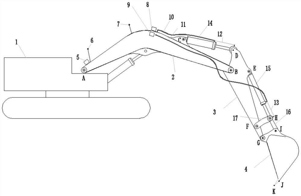
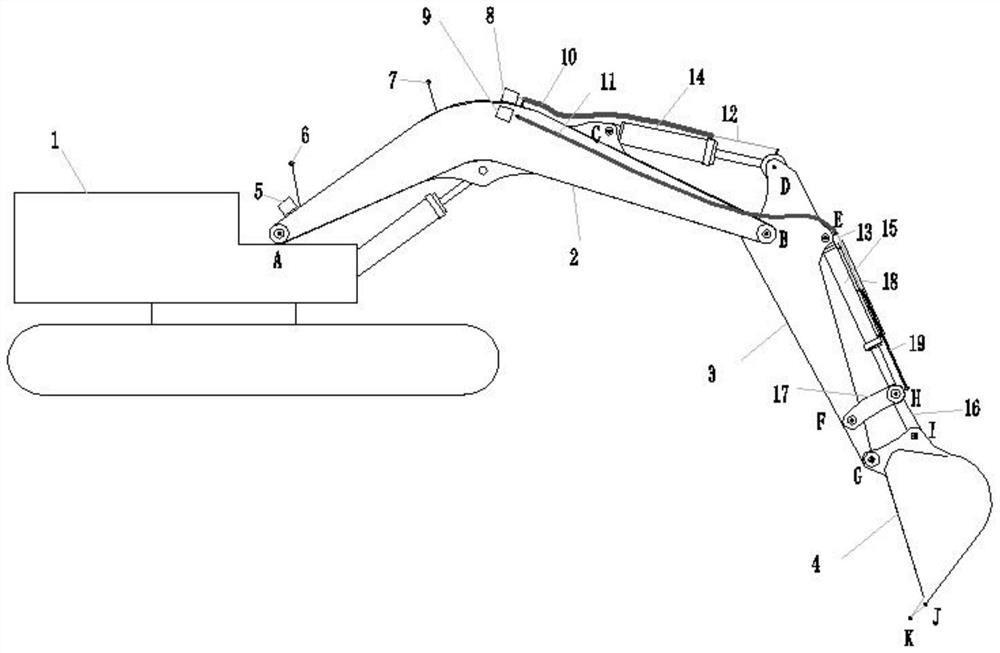
[0035] Such as figure 1 As shown, an excavator construction guidance system includes an excavator body 1, a boom 2, a stick 3, and a bucket 4. The excavator is equipped with a positioning module and a measuring stick for measuring and estimating the pose information of the boom 2 The measuring assembly for the telescopic length of the hydraulic cylinder 14 and / or the bucket hydraulic cylinder 15 also includes a measuring terminal.

[0036] The measurement terminal can be specifically a computer, which can receive the measurement information of the positioning module and measurement components through the serial port; calculate the position and orientation information of the boom 2, stick 3 and bucket 4 according to the measurement information; use software to establish the terrain model of the construction site and the bucket 4 simulation model, and determine the pose of the bucket 4 simulation model according to the pose information of the bucket 4, thereby determining the po...


PUM


Abstract

The invention discloses an excavator construction guiding system which comprises an excavator body, a movable arm, a bucket rod and a bucket. The excavator body and / or the movable arm are / is providedwith a positioning module used for measuring pose information of the movable arm, the excavator is provided with a measuring assembly used for measuring the telescopic length of a bucket rod hydraulicoil cylinder and / or a bucket hydraulic oil cylinder, the excavator construction guiding system further comprises a measuring terminal, the measuring terminal is used for receiving measuring information of the positioning module and the measuring assembly, a sensor of the measuring bucket is far away from the severe environment, and the system is easier to maintain. The construction method comprises the following steps: calculating pose information of the movable arm, the bucket rod and the bucket according to the measurement information; establishing a construction site terrain model by utilizing software, and determining the pose of a bucket simulation model according to the pose information of the bucket; and guiding construction according to a plane graph and a section graph, and dynamically simulating the topographic construction excavation condition of the construction site according to the path track of the shovel teeth. By comparing an excavated terrain model with a designed terrain section, the actual excavation condition of the construction site is determined, and the phenomena of over-excavation, under-excavation, missed excavation and repeated excavation are avoided.

Description

technical field [0001] The invention relates to the technical field of measurement, in particular to an excavator construction guidance system and a construction method. Background technique [0002] The excavator includes excavator car body, boom, stick and bucket. The stick is hinged with the boom and is driven by the stick hydraulic cylinder to rotate between the stick and the boom. The joint is hinged, and the rotation between the bucket and the stick is driven by the bucket hydraulic cylinder. The existing excavator measurement system is generally two GNSS satellite receiving antennas installed on the car body, and the angle measuring sensor is directly installed on the car body, boom, stick, the rotating shaft of the car body and boom, the boom and stick On the rotating shaft, the rotating shaft of the arm and bucket, and the rocker of the bucket, the three-dimensional coordinates of the bucket teeth need to be estimated from the vehicle body to calculate the spatial ...

Claims


Application Information

Patent Timeline
IPC IPC(8): E02F9/20E02F9/28G06F30/23G06T17/20G01B7/02
CPCE02F9/2045E02F9/2808G01B7/02G06T17/20G06F30/23
Inventor 蔡应广丘柏华丘加发
Owner 广州三维可视化测绘科技有限公司
Learn More