Large-format surveying and mapping camera system and calibration method

A surveying and mapping camera, a large-format technology, applied in the direction of measuring devices, instruments, etc., can solve the problems of strict constraints on the use of the camera's internal space, halo in image splicing, and difficulty in splicing.

Active Publication Date: 2020-12-15
BEIJING RES INST OF SPATIAL MECHANICAL & ELECTRICAL TECH
View PDF6 Cites 1 Cited by
  • Summary
  • Abstract
  • Description
  • Claims
  • Application Information

AI Technical Summary

Problems solved by technology

This method must require the lens to be arranged in a "one" character, and there is a problem of strict constraints on the use of the internal space of the camera, and it is difficult to achieve larger format stitching under the same device selection
[0005] Invention patents CN 102883095A and CN 102905061A both use double lenses and beam-splitting prisms to achieve splicing. There is a 50% energy loss for each image plane, and there are deficiencies in that the beam-splitting prism increases the volume and weight of the optical system and there is a halo at the image splicing place.

Method used


Image

  • Large-format surveying and mapping camera system and calibration method
  • Large-format surveying and mapping camera system and calibration method
  • Large-format surveying and mapping camera system and calibration method

Examples


Embodiment Construction

[0043] Exemplary embodiments of the present disclosure will be described in more detail below with reference to the accompanying drawings. Although exemplary embodiments of the present disclosure are shown in the drawings, it should be understood that the present disclosure may be embodied in various forms and should not be limited by the embodiments set forth herein. Rather, these embodiments are provided for more thorough understanding of the present disclosure and to fully convey the scope of the present disclosure to those skilled in the art. It should be noted that, in the case of no conflict, the embodiments of the present invention and the features in the embodiments can be combined with each other. The present invention will be described in detail below with reference to the accompanying drawings and examples.

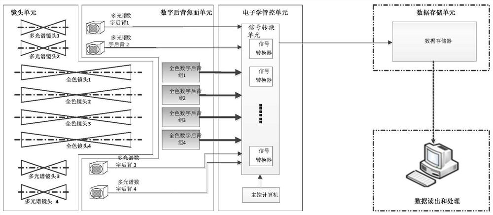
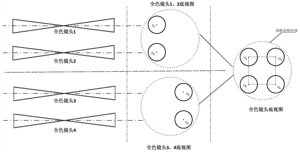
[0044] figure 1 It is an overall block diagram of the large-format surveying and mapping camera system provided by the embodiment of the present invention. ...


PUM


Abstract

The invention discloses a large-format surveying and mapping camera system, which comprises a lens unit, a digital back focal plane unit, an electronics management and control unit and a data storageunit, wherein the lens unit comprises a first multispectral lens, a second multispectral lens, a third multispectral lens, a fourth multispectral lens, a first panchromatic lens, a second panchromaticlens, a third panchromatic lens and a fourth panchromatic lens; the digital back focal plane unit comprises a first multispectral digital back, a second multispectral digital back, a third multispectral digital back, a fourth multispectral digital back, a first panchromatic digital back group, a second panchromatic digital back group, a third panchromatic digital back group and a fourth panchromatic digital back group; and the electronics management and control unit comprises a signal conversion unit and a main control computer. According to the invention, the aerial survey camera can have alarge breadth, and the operation efficiency and precision of the aerial survey camera are improved.

Description

technical field [0001] The invention belongs to the technical field of photoelectric imaging, and in particular relates to a large-format surveying and mapping camera system and a calibration method. Background technique [0002] Aerial optical mapping is an important technical means to efficiently obtain regional remote sensing information. Large-format surveying and mapping cameras can obtain high resolution and wide field of view, improve operational efficiency, and save operating costs. At the same time, they can be supplemented with slightly lower-resolution multispectral images to obtain multispectral information in different spectral bands to better serve surveying and mapping applications. [0003] It is an inevitable trend for area array surveying and mapping cameras to develop towards ultra-large format. The pixel size is 4μm-6μm, and the total number of pixels is 800-1600 million. Restricted by the technology level, it is difficult to realize CCD or CMOS area arr...

Claims


Application Information

Patent Timeline
IPC IPC(8): G01C25/00
CPCG01C25/00
Inventor 刘秀高树义钟灿宋立国袁胜帮曹桂丽王洪民张翠张旭
Owner BEIJING RES INST OF SPATIAL MECHANICAL & ELECTRICAL TECH
Why Eureka
Try Eureka