Path planning method and device, equipment and storage medium
A path planning, to-be-planned technology, applied in image enhancement, image analysis, data processing applications, etc., can solve problems such as lack of three-dimensional information, inability to cover the randomness of obstacle areas, and inability to avoid obstacles, and improve work efficiency. Effect
- Summary
- Abstract
- Description
- Claims
- Application Information
AI Technical Summary
Problems solved by technology
Method used
Image


Examples
Embodiment 1
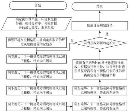
[0028] figure 1 It is a schematic flowchart of a path planning method provided in Embodiment 1 of the present invention. This embodiment can be applied to the grid of the environmental grayscale grid map when the environmental grayscale grid map is determined according to the point cloud data. In the case of traversing to generate a target planning path, the method may be performed by a path planning apparatus, wherein the apparatus may be implemented in software and / or hardware, and is generally integrated in a path planning apparatus. For details, see figure 1 As shown, the method may include the following steps:
[0029] S110. Determine the environmental grayscale grid map of the plane to be planned.
[0030] The plane to be planned may be a building floor or a ground. The environmental grayscale grid map is a two-dimensional grid map corresponding to the point cloud data, including the three-dimensional information of obstacles on the plane to be planned. like figure...
Embodiment 2
[0045] Image 6 This is a schematic flowchart of a path planning method according to Embodiment 2 of the present invention. The technical solution of this embodiment adds new steps on the basis of the above-mentioned embodiment. Optionally, before the determination of the environmental grayscale grid map of the plane to be planned, the method further includes: acquiring the first coordinate data of any point cloud data, the pixel size of the initial grid map, and the point The minimum coordinates of the cloud data; the second coordinate data of the grid point corresponding to any point cloud data is calculated according to the first coordinate data, the pixel size and the minimum coordinates; according to the first coordinate data of the point cloud data The coordinate data and the second coordinate data of the grid point determine the mapping relationship. For the part not described in detail in the method embodiment, please refer to the above-mentioned embodiment. For det...
Embodiment 3
[0080] Figure 7 This is a schematic structural diagram of a path planning apparatus provided in Embodiment 3 of the present invention. see Figure 7 As shown, the device includes: an environment grayscale grid map determination module 310 , a grid traversal module 320 , a target traversal grid determination module 330 and a target planning path generation module 340 .
[0081] Wherein, the environmental grayscale grid map determination module 310 is used to determine the environmental grayscale grid map of the plane to be planned, wherein the environmental grayscale grid map includes three-dimensional information of obstacles on the plane to be planned;
[0082] The grid traversal module 320 is configured to perform expansion processing on the obstacle grid in the environmental grayscale grid image, and perform expansion processing on the expanded environmental grayscale grid based on the starting point of the expanded environmental grayscale grid image. Traverse the graph ...
PUM
 Abstract
Description
Claims
Application Information
 - R&D
- Intellectual Property
- Life Sciences
- Materials
- Tech Scout
- Unparalleled Data Quality
- Higher Quality Content
- 60% Fewer Hallucinations
Browse by: Latest US Patents, China's latest patents, Technical Efficacy Thesaurus, Application Domain, Technology Topic, Popular Technical Reports.
© 2025 PatSnap. All rights reserved.Legal|Privacy policy|Modern Slavery Act Transparency Statement|Sitemap|About US| Contact US: help@patsnap.com