Unmanned aerial vehicle flight platform for intelligent geographic remote sensing surveying and mapping

A technology of flying platform and UAV, which is applied in the direction of aircraft, motor vehicles, aircraft parts, etc., can solve the problems of large impact force of UAV and damage of UAV, and achieve the effect of improving the effect of buffering

Inactive Publication Date: 2020-11-27
YELLOW RIVER CONSERVANCY TECHN INST
View PDF10 Cites 3 Cited by
  • Summary
  • Abstract
  • Description
  • Claims
  • Application Information

AI Technical Summary

Problems solved by technology

[0003] The invention provides a UAV flight platform for intelligent geographical remote sensing surveying and mapping, to solve the problem that the existing UAVs are subjected to a large impact force when they descend, and the UAVs are easy to be damaged.

Method used


Image

  • Unmanned aerial vehicle flight platform for intelligent geographic remote sensing surveying and mapping
  • Unmanned aerial vehicle flight platform for intelligent geographic remote sensing surveying and mapping
  • Unmanned aerial vehicle flight platform for intelligent geographic remote sensing surveying and mapping

Examples


Embodiment Construction

[0026] The following will clearly and completely describe the technical solutions in the embodiments of the present invention with reference to the accompanying drawings in the embodiments of the present invention. Obviously, the described embodiments are only some, not all, embodiments of the present invention. Based on the embodiments of the present invention, all other embodiments obtained by persons of ordinary skill in the art without making creative efforts belong to the protection scope of the present invention.

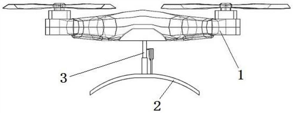
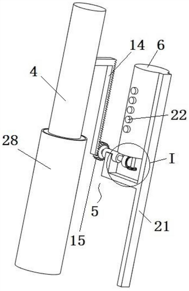
[0027] An embodiment of an unmanned aerial vehicle flight platform for intelligent geographical remote sensing surveying and mapping of the present invention, as Figure 1 to Figure 6 as shown,

[0028] An unmanned aerial vehicle flight platform for intelligent geographic remote sensing surveying and mapping includes an unmanned aerial vehicle body 1 , a landing stand 2 and an adaptive buffer device 3 . The landing stand 2 is arranged under the UAV body 1 for...


PUM


Abstract

The invention relates to an unmanned aerial vehicle flight platform for intelligent geographic remote sensing surveying and mapping. The platform comprises an unmanned aerial vehicle body, a landing frame, a buffer mechanism, a bracket, a switching mechanism and a transmission mechanism. The landing frame is arranged below the unmanned aerial vehicle body. The buffering mechanism comprises a supporting column, an electromagnet, a permanent magnet and a spring. The switching mechanism comprises a power supply, an outer shell, an inner cylinder, a plurality of conductive columns, an output shaftand a plurality of blades, and the transmission mechanism is configured to transmit downward movement of the supporting column under the pushing of the unmanned aerial vehicle body to the output shaft and enable the output shaft to rotate for electric conduction. When the unmanned aerial vehicle flight platform for intelligent geographic remote sensing surveying and mapping lands, the reverse thrust repulsion intensity can be adaptively adjusted according to the descending speed of the unmanned aerial vehicle body when the unmanned aerial vehicle body lands, and the buffering effect of the unmanned aerial vehicle body during landing is improved. Preferably, the unmanned aerial vehicle body stops descending before the spring balance point, and at the moment, even if the repulsive force ofthe electromagnet is removed, the unmanned aerial vehicle body cannot rebound.

Description

technical field [0001] The invention relates to the field of surveying and mapping equipment, in particular to an unmanned aerial vehicle flight platform for intelligent geographical remote sensing surveying and mapping. Background technique [0002] Surveying and mapping refers to surveying and drawing. Based on computer technology, photoelectric technology, network communication technology, space science, and information science, with global navigation satellite positioning system, remote sensing, and geographic information system as the technical core, the existing feature points on the ground are And the boundary line obtains the graphics and position information reflecting the current situation of the ground by means of measurement, which is used for the planning, design and administrative management of engineering construction. Generally speaking, it refers to the shape, size, spatial position and attributes of natural geographical elements or surface artificial facilit...

Claims


Application Information

Patent Timeline
Patent Type & Authority Applications(China)
IPC IPC(8): B64C39/02B64C25/58B64C25/62
CPCB64C25/58B64C25/62B64C39/02
Inventor 郭玉珍张向伟张辉张丹王瑞芳
Owner YELLOW RIVER CONSERVANCY TECHN INST
Why Eureka
Try Eureka