


Quick Research
Generate reliable direction feasibility study reports for your R&D in just a few steps.

Technical Q&A
Discover and master advanced knowledge NOW. Basics, ideas, possibilities, all at once.

Find Solutions
As an expert in R&D theories, this can generate solutions to your technical problems instantly.

Evaluate Feasibility
Analyze your overall solution with one click, know your potential R&D risks in advance.

Monitor Landscape
Get weekly tech updates, stay abreast of the latest tech innovations and key insights.
Remote sensing monitoring pattern spot docking system and using method thereof
A technology for remote sensing monitoring and patterning, which is applied in the field of remote sensing monitoring pattern docking system to achieve the effect of facilitating system identification, ensuring flexibility and scalability, and low demand risk
- Summary
- Abstract
- Description
- Claims
- Application Information
AI Technical Summary
Problems solved by technology
Method used
Image

Examples
Embodiment 1
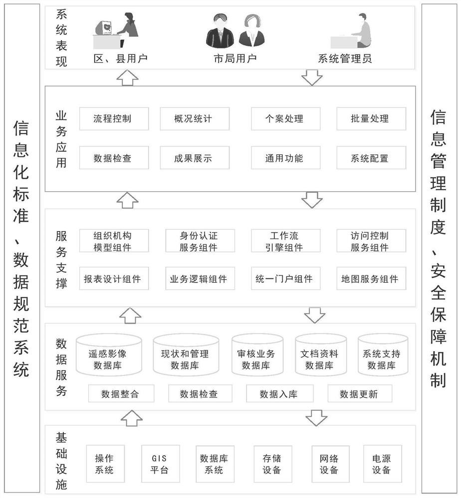
[0045] as attached figure 1 As shown, a remote sensing monitoring pattern docking system includes an infrastructure module, a data service module, a service support module, a business application module, and a system performance module.
[0046] The infrastructure module is connected to the data service module, the service support module is connected to the data service module, the business application module is connected to the data service module, and the system performance module is connected to the business application module connect.
[0047] The infrastructure module includes operating system, GIS platform, database system, storage device, network device and power supply device.
[0048] The data service, that is, the module or the database platform, solves the problem of data storage and ensures high-performance computing; including data integration module, data inspection module, data storage module, data update module, remote sensing image database, status and manage...
Embodiment 2
[0096] Based on the above-mentioned embodiment 1, a method for using a remote sensing monitoring patch docking system includes the following steps:
[0097] S1. Cadastral affairs center user establishment project;
[0098] S2, district and county users export data;
[0099] S3. District and county users refer to the materials, fill in the information in the project, and upload graphics and materials;
[0100] Further, the uploading of graphics and materials is performed in a batch uploading manner.
[0101] S4. The system automatically assigns cases to business departments or municipal bureaus according to the information filled in. Different departments review the cases according to the specific filled content, save different review conclusions, and send them to districts, counties or case completion boxes after submission.
Embodiment 3
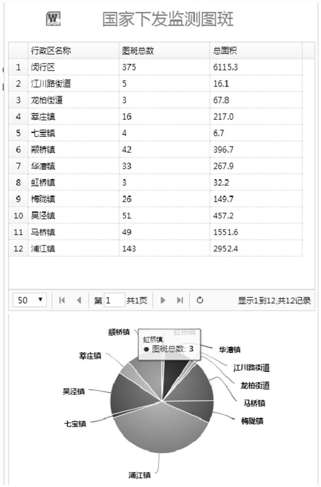
[0103] Based on the above-mentioned embodiment 1, taking Shanghai as an example, the system performance module is mainly oriented to users such as the Shanghai Municipal Planning and Land Resources Bureau, the district and county planning and land resources bureaus, the cadastral department, the comprehensive security department, the land department, and the law enforcement brigade, providing national Issue functions such as online reporting of remote sensing monitoring patterns, online review, statistical analysis, and results display.
[0104] According to the authority of the user, the function of viewing the statistical chart of the data is given, as attached figure 2 As shown, the monitoring map issued by the state shows the geographical distribution and area of the monitoring map issued by the state, the district user sees the distribution within the jurisdiction, and the city bureau user sees the distribution of the city's monitoring map In some cases, it is supporte...
PUM
 Abstract
Description
Claims
Application Information
 - R&D Engineer
- R&D Manager
- IP Professional
- Industry Leading Data Capabilities
- Powerful AI technology
- Patent DNA Extraction
Browse by: Latest US Patents, China's latest patents, Technical Efficacy Thesaurus, Application Domain, Technology Topic, Popular Technical Reports.
© 2024 PatSnap. All rights reserved.Legal|Privacy policy|Modern Slavery Act Transparency Statement|Sitemap|About US| Contact US: help@patsnap.com