Online planning and suitability analysis method and system for terrain-aided navigation matching area

A terrain-assisted navigation and analysis method technology, applied in the field of navigation and positioning, can solve problems such as low accuracy of assisted positioning results, and achieve the effects of avoiding poor positioning results, solving error accumulation, filtering divergence, and reducing time consumption.

Active Publication Date: 2020-11-06
BEIHANG UNIV
View PDF6 Cites 1 Cited by
  • Summary
  • Abstract
  • Description
  • Claims
  • Application Information

AI Technical Summary

Problems solved by technology

However, the terrain-assisted navigation system is greatly affected by terrain characteristics. When the carrier is in a mountainous area with a large terrain slope, hills, etc., the auxiliary positioning results are more accurate; Assisted location results are less accurate

Method used


Image

  • Online planning and suitability analysis method and system for terrain-aided navigation matching area
  • Online planning and suitability analysis method and system for terrain-aided navigation matching area
  • Online planning and suitability analysis method and system for terrain-aided navigation matching area

Examples


Embodiment Construction

[0074] The following will clearly and completely describe the technical solutions in the embodiments of the present invention with reference to the accompanying drawings in the embodiments of the present invention. Obviously, the described embodiments are only some, not all, embodiments of the present invention. Based on the embodiments of the present invention, all other embodiments obtained by persons of ordinary skill in the art without making creative efforts belong to the protection scope of the present invention.

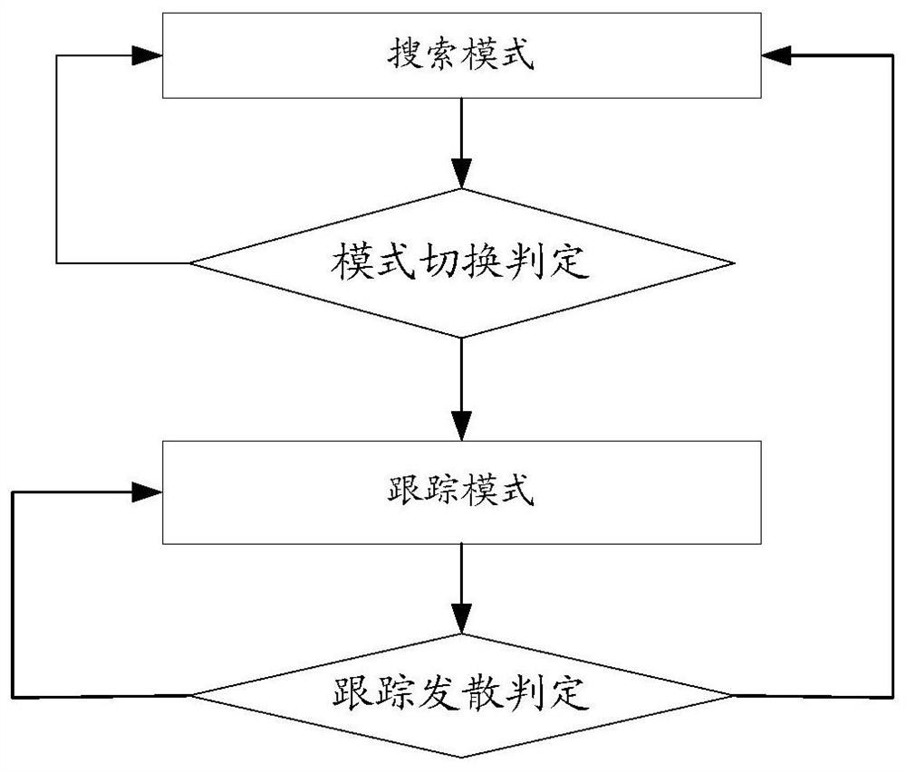
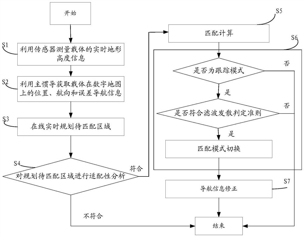
[0075] Such as Figure 2-7 As shown, the embodiment of the present invention discloses a method for online planning and adaptability analysis of a terrain-assisted navigation matching area, including the following steps:

[0076] Step S1: Measuring the real-time terrain height information of the carrier by using the sensor.

[0077] Step S2: Use the primary inertial navigation to obtain the position, heading and error navigation information of the carrier on ...


PUM


Abstract

The invention discloses an on-line planning and suitability analysis method for a terrain-aided navigation matching area. The method comprises the following steps: acquiring real-time terrain height information of a carrier and position, heading and error navigation information of the carrier on a digital map; planning a to-be-matched area on line in real time according to the navigation information; carrying out full-map suitability analysis on a pre-loaded digital map, and carrying out suitability analysis on the planned to-be-matched area; deciding whether to perform subsequent matching calculation or not according to the adaptation analysis result of the to-be-matched area; if the adaptation analysis result of the to-be-matched area meets the condition and enters a matching tracking mode, deciding whether the matching mode is switched or not according to the filtering divergence judgment criterion; and correcting the navigation information according to a matching calculation resultto complete terrain-aided navigation. According to the method, redundant calculation can be avoided through online real-time planning of the to-be-matched area, suitability analysis and tracking filtering judgment, the time consumption of terrain aided navigation is effectively reduced, and the positioning accuracy of the system is improved.

Description

technical field [0001] The invention relates to the technical field of navigation and positioning, and more specifically relates to a method and system for online planning and adaptability analysis of terrain-assisted navigation matching areas. Background technique [0002] As one of the widely used integrated navigation systems, Terrain Aided Navigation (TAN) has the advantages of strong anti-interference ability, high universality, and easy operation and implementation. field. Currently, the terrain-assisted navigation system mainly uses the TERCOM algorithm and the SITAN algorithm. Since the TERCOM algorithm needs to measure a series of terrain elevation sequences, the real-time performance is not as good as the SITAN algorithm. [0003] The basic principle of terrain-assisted navigation under the SITAN algorithm is to measure the terrain height directly below the flight path of the carrier, compare it with the reference elevation data stored in advance, and use the matc...

Claims


Application Information

Patent Timeline
Patent Type & Authority Applications(China)
IPC IPC(8): G01C21/20G06F16/29G06F17/11G06K9/62
CPCG01C21/20G06F17/11G06F16/29G06F18/22
Inventor 赵龙陈瑞张且且
Owner BEIHANG UNIV
Why Eureka
Try Eureka