
Simultaneous positioning and mapping method, system, device and storage medium

A technology for map data and communication establishment, applied in the field of computer vision, can solve the problems of insufficient computing power, storage capacity and energy consumption, and achieve the effect of ensuring real-time performance

Active Publication Date: 2020-12-04
PENG CHENG LAB
View PDF10 Cites 0 Cited by
  • Summary
  • Abstract
  • Description
  • Claims
  • Application Information

AI Technical Summary

Problems solved by technology

[0003] The embodiment of the present application solves the technical problem of insufficient computing power, storage capacity and energy consumption in the advanced SLAM process of real-time interaction with the environment by providing a method for simultaneous positioning and mapping, and achieves the semantic perception of the environment and the ability to communicate with the environment. The technical effect of advanced SLAM precision service with real-time interaction with the environment

Method used


Image

  • Simultaneous positioning and mapping method, system, device and storage medium
  • Simultaneous positioning and mapping method, system, device and storage medium
  • Simultaneous positioning and mapping method, system, device and storage medium

Examples


Embodiment Construction

[0065] In order to better understand the above-mentioned technical solution, the above-mentioned technical solution will be described in detail below in conjunction with the accompanying drawings and specific implementation methods.

[0066] This application relates to a simultaneous positioning and mapping method, the system includes:

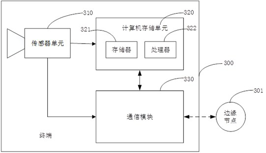
[0067] The terminal 300 is configured to connect to edge nodes based on wireless communication; the terminal is configured to: the sensor unit 310 acquires the data of the surrounding environment of the terminal and its own motion state; the calculation and storage unit 320 uses the information acquired by the sensor unit 310 to calculate the position and At the same time, the basic map is calculated; the communication unit 330 uploads the calculated second map data to the edge node.

[0068] The computer storage unit 320 includes such as image 3 Shown: at least one processor 322 , memory 321 .

[0069] The processor 322 may be an integrate...


PUM


Abstract

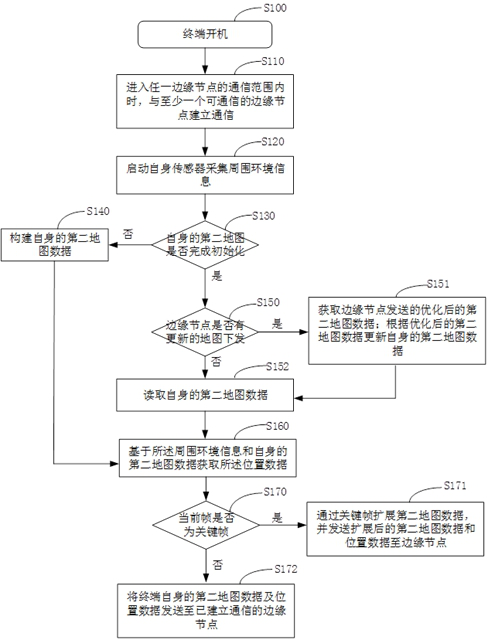
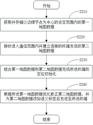
The invention discloses a simultaneous positioning and mapping method, system, equipment and storage medium. The method includes: when entering the communication range of any edge node, establishing communication with at least one communicable edge node; the edge node stores the first map data within a set range centered on the edge node; The second map data and location data are sent to the edge nodes that have established communication; wherein, the first map data has denser point cloud data than the second map data, and the point cloud data of the first map data has semantic labels; obtain the edge The optimized second map data sent by the node; updating its own second map data according to the optimized second map data. It solves the problem of insufficient computing power, storage capacity and energy consumption in the advanced SLAM process of real-time interaction with the environment, and achieves the effect of satisfying the semantic perception of the environment and the high-level SLAM precision service of real-time interaction with the environment.

Description

technical field [0001] The invention relates to the field of computer vision, in particular to a SLAM method based on an edge computing network. Background technique [0002] Existing SLAM (Simultaneous localization and mapping, simultaneous localization and mapping technology) schemes can be divided into stand-alone SLAM and multi-machine SLAM. At present, most of the research schemes are mainly stand-alone SLAM, that is, positioning and perception of the environment. It is completed on the same mobile device, but due to the limitations of computing power and power consumption of the mobile platform, this type of SLAM solution cannot create high-precision detailed maps, and a small number of multi-machine SLAM solutions can only complete basic mapping tasks. The basic map can basically meet the needs of device positioning, but it is far from meeting the needs of application services such as semantic perception of the environment and providing advanced interaction between de...

Claims


Application Information

Patent Timeline
Patent Type & Authority Patents(China)
IPC IPC(8): G06F16/23G06F9/50G06F16/29G06K9/62G06T7/50G06T17/05
CPCG06F16/29G06F16/23G06F9/5072G06T17/05G06T7/50G06T2207/10028G06F18/22Y02D10/00
Inventor 陈俊宏郑名飞熊亮柳伟何震宇田第鸿
Owner PENG CHENG LAB
Learn More