
UAV-based foundation pit monitoring method

A technology of unmanned aerial vehicles and foundation pits, which is applied in the field of construction, can solve problems such as singleness and inability to realize real-time monitoring and feedback, and achieve the effect of avoiding errors and facilitating image viewing and comparison

Active Publication Date: 2020-09-29
山东地矿开元工程科技有限公司
View PDF5 Cites 1 Cited by
  • Summary
  • Abstract
  • Description
  • Claims
  • Application Information

AI Technical Summary

Problems solved by technology

Most of the current monitoring measures are manual on-site surveying and mapping or taking photos and comparing photos. This method is too single and cannot achieve real-time monitoring feedback. Therefore, it is imminent to promote the informatization and dynamicization of foundation pit monitoring.

Method used


Image

  • UAV-based foundation pit monitoring method
  • UAV-based foundation pit monitoring method
  • UAV-based foundation pit monitoring method

Examples


specific Embodiment approach 1

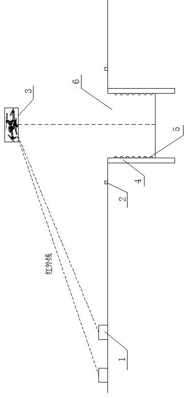
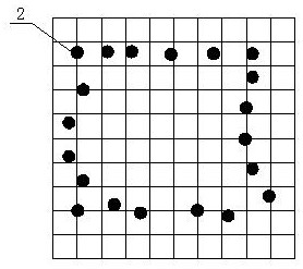
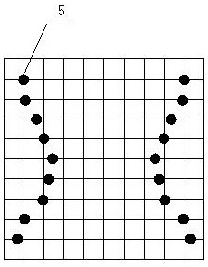
[0018] Specific embodiment one, as can be seen from the accompanying drawings, the drone-based foundation pit monitoring method of this solution has two infrared positioning transmitters 1 set 100m away from the foundation pit, and the two infrared positioning transmitters 1 emit The infrared intersection point is the UAV monitoring point, and the infrared intersection point of the two infrared positioning transmitters 1 is located directly above the center of the foundation pit 6. UAV 3 has infrared receiving function and camera function, UAV 3 is in the design Monitoring is performed at a predetermined time period and the data of each monitoring is saved. In this specific embodiment, the drone obtains data every 2 hours. The monitored data includes the position of the horizontal foundation pit detector 2, the position of the vertical foundation pit detector 5, and the photos taken.

[0019] A plurality of horizontal foundation pit detectors 2 are set around the foundation pit ...

specific Embodiment approach 2

[0022] Specific implementation manner two, as can be seen from the attached drawings, the UAV-based foundation pit monitoring method of this solution has two infrared positioning transmitters 1 and two infrared positioning transmitters set at a distance greater than 100m from the foundation pit. The intersection of the infrared rays emitted is the UAV monitoring point, and the infrared intersection point of the two infrared positioning transmitters 1 is located directly above the center of the foundation pit 6. UAV 3 has infrared receiving function and camera function, UAV 3 Monitor in the set time period and save the data of each monitoring. In this specific embodiment, the drone obtains data every 2 hours. The monitored data includes the position of the horizontal foundation pit detector 2, the position of the vertical foundation pit detector 5, and the photos taken.

[0023] A plurality of horizontal foundation pit detectors 2 are set around the foundation pit 6 to monitor wh...


PUM


Abstract

The invention provides a UAV-based foundation pit monitoring method. The method comprises the steps of setting a UAV monitoring point at a fixed position above a foundation pit, using the UAV to monitor in a set time period, and saving data for each monitoring. Images are taken through the using of a high-definition camera on the UAV. The infrared ray of a foundation pit monitor can be received, and the position of the foundation pit monitor can be determined. The information is transmitted to the computer terminal to realize visual monitoring of foundation pit construction process and ensuresafe and orderly construction.

Description

Technical field [0001] The invention relates to the field of construction, in particular to a drone-based foundation pit monitoring method, which is suitable for a foundation pit excavation and construction process, and can monitor various construction data in the foundation pit excavation process in real time to realize modern construction. Background technique [0002] my country's civil engineering industry is in a period of rapid development, and the development of underground space has attracted more and more attention. However, the complex and diverse underground environment has led to frequent foundation pit accidents. Therefore, it is necessary to monitor the construction process of foundation pits. The current monitoring measures are mostly manual on-site surveying and mapping or taking photos and comparing photos. This method is too single and cannot realize real-time monitoring feedback. Therefore, it is urgent to promote the information and dynamics of foundation pit m...

Claims


Application Information

Patent Timeline
Patent Type & Authority Applications(China)
IPC IPC(8): E02D33/00E02D17/02B64C39/02
CPCE02D33/00E02D17/02B64C39/02B64U10/10B64U30/20B64U2101/00
Inventor 许杰刘洋胡国庆李咀伟钟原
Owner 山东地矿开元工程科技有限公司
Learn More