Method for planning multiple collision-free air routes in same area based on A * algorithm

A same-area, collision-free technology, applied in three-dimensional position/course control, vehicle position/route/height control, advanced technology, etc., can solve the problem of unsmooth routes, many inflection points, unfavorable UAV tracking routes, etc., to achieve The effect of smoothing the route, reducing the number of turns, and ensuring availability

Active Publication Date: 2020-07-10
XIAN AISHENG TECH GRP
View PDF10 Cites 9 Cited by
  • Summary
  • Abstract
  • Description
  • Claims
  • Application Information

AI Technical Summary

Problems solved by technology

Among them, the A* algorithm is a classic heuristic search algorithm, which is the most effective direct search method for solving the shortest path in a static road network. Although this method can obtain the route of the shortest path, the route obtained by this method is not smooth enough. There are too many inflection points, which is not conducive to UAV tracking routes, and this method is suitable for single route planning, but cannot be used for multiple route planning

Method used


Image

  • Method for planning multiple collision-free air routes in same area based on A * algorithm
  • Method for planning multiple collision-free air routes in same area based on A * algorithm
  • Method for planning multiple collision-free air routes in same area based on A * algorithm

Examples


Embodiment 1

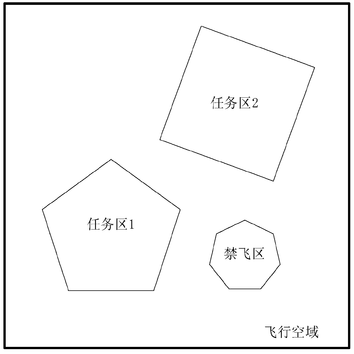
[0046] Step 1: Obtain 1 flight airspace, 1 no-fly zone and 2 mission target areas.

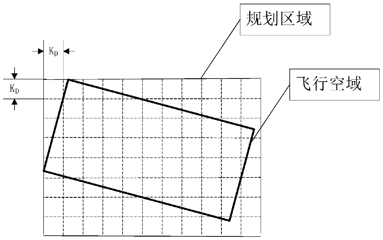
[0047] Determine the scope of the planning area according to the given flight airspace, and the planning area consists of multiple sides whose length is K D The square composition, K D The value is 800m. The scope of the planning area is the smallest circumscribed rectangular area of ​​the flight airspace.

[0048] Step 2: Obtain the start point and end point of the route. The starting point is the take-off point of the drone, which is set to the same starting point. The smallest square grid is used as a node, and all node information is initialized to be able to pass through, and then the grids crossed by the flight airspace, no-fly zone and mission target area obtained in step 1 are respectively calculated, and the corresponding node information is set as If it cannot pass, finally calculate the grid where the start point and end point are located, and set the search start point and searc...


PUM


Abstract

The invention relates to a method for planning multiple collision-free air routes in the same area based on an A * algorithm. The A * algorithm is used for searching the flight route flying from the take-off point to the task area entry point, the grid range and the waypoint optimization conditions are reasonably planned, the availability of the planned flight route of the unmanned aerial vehicleis guaranteed, the turning frequency of the unmanned aerial vehicle is reduced, the route is smoothened, and it can be guaranteed that the unmanned aerial vehicle is always located in the planned flight area.

Description

technical field [0001] The present invention relates to the field of UAV route planning, more specifically, refers to a method for planning multiple non-collision routes in the same area based on the A* algorithm. Background technique [0002] Before the UAV performs a mission, it needs to bind the route on the ground. The route generally uses multiple waypoints to form a series of waypoints, and then connects the waypoints with line segments. The UAV follows these waypoints. The geographic coordinate information of the drone is used to fly, so as to guide the drone to fly to the predetermined area along the predetermined route. [0003] When the same flight area contains several small mission areas, and a corresponding number of UAVs are required to fly to the designated mission area, the flight route of each UAV and the impact of the no-fly zone should be fully considered during mission planning. The most common planning method is to use manual planning, considering the m...

Claims


Application Information

Patent Timeline
IPC IPC(8): G05D1/10
CPCG05D1/101Y02D30/70
Inventor 肖佳伟麻兴斌王晶薛博文
Owner XIAN AISHENG TECH GRP
Why Eureka
Try Eureka