Crowd funding photo and two-dimensional map combined building three-dimensional modeling method

A technology of 3D modeling and 2D map, applied in the field of 3D modeling of buildings, which can solve the problems of small coverage of photo data and lack of photos.

Active Publication Date: 2020-07-07
NANJING UNIV +1
View PDF4 Cites 4 Cited by
  • Summary
  • Abstract
  • Description
  • Claims
  • Application Information

AI Technical Summary

Problems solved by technology

Fan et al. proposed to use OSM data and VGI photo data for 3D modeling, but the coverage of photo data is small, and there is a lack of photos from different angles of the same building

Method used


Image

  • Crowd funding photo and two-dimensional map combined building three-dimensional modeling method
  • Crowd funding photo and two-dimensional map combined building three-dimensional modeling method
  • Crowd funding photo and two-dimensional map combined building three-dimensional modeling method

Examples


Embodiment Construction

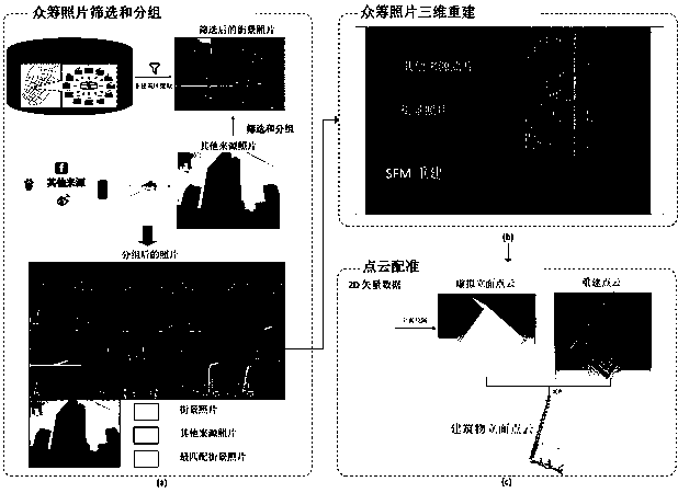
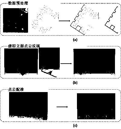
[0055] The present invention will be described in detail below according to the accompanying drawings, so as to make the technical route and operation steps of the present invention clearer.

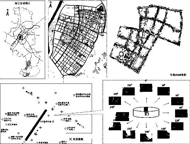
[0056] In this embodiment, Jianye District, Nanjing City is selected as the experimental area, such as image 3 shown. Jianye District is one of the main urban areas of Nanjing. It is located in the southwest of Nanjing City, adjacent to the Outer Qinhuai River and Qinhuai New River in the east and south, the Yangtze River in the west, and Hanzhongmen Street in the north. Jianye District includes not only the old urban area with relatively low and dense buildings, but also the new urban construction area with many modern high-rise buildings. The types of buildings and the structural characteristics of facades are diverse, which is suitable for 3D modeling and result analysis of buildings on both sides of the street. Typical and representative. The test area covers an area of ​​about 29...


PUM


Abstract

The invention relates to a crowd funding photo and two-dimensional map combined building three-dimensional modeling method, which comprises the following steps of: downloading and organizing streetscape data; extracting a non-building region of streetscape photos; retrieving and grouping the photos; screening the photos; performing three-dimensional modeling based on crowd funding photos; and carrying out point cloud registration based on 2D vector data. The crowd funding photo data which are free and easy to obtain are adopted, are low in cost, and can be obtained in a large scale; a new building photo data source is introduced, the method is a three-dimensional modeling method for multi-source data integration; and an adopted three-step strategy comprises photo screening and grouping, three-dimensional modeling based on the crowd funding photos and point cloud registration based on 2D vector data. According to the crowd funding photo and two-dimensional map combined building three-dimensional modeling method, the potential value of the streetscape data is mined, the availability of the streetscape data is improved, and a data source is provided for large-scale urban building three-dimensional modeling; and the method is ingeniously combined with a photo retrieval method, and realizes quick grouping of massive streetscape data through introducing photos of other source .

Description

technical field [0001] The invention relates to a three-dimensional building modeling method, in particular to a large-scale three-dimensional building modeling method combining crowdfunding photos and two-dimensional map data. Background technique [0002] With the continuous development of digital cities, the demand for building 3D models is gradually increasing. The establishment of 3D model of buildings is a research hotspot in the fields of geographic information science and remote sensing. In recent years, the rapid development of computer vision technology and the emergence of high-resolution and high-precision photogrammetry technology and UAV technology have provided new methods and technologies for building high-quality 3D models of buildings. Building 3D modeling technology has been widely used in urban planning, 3D real scene navigation, urban virtual tourism and other fields. Large-scale 3D modeling of buildings has practical significance for multi-dimensional...

Claims


Application Information

Patent Timeline
Patent Type & Authority Applications(China)
IPC IPC(8): G06T17/05G06T11/20G06T7/33G06T7/11G06T7/62
CPCG06T17/05G06T11/206G06T7/33G06T7/11G06T7/62G06T2210/04G06T2207/10028
Inventor 不公告发明人
Owner NANJING UNIV
Why Eureka
Try Eureka