Methods based on the changing model of the tide zone area to predict the development trend of the future tide zone area

A technology of area change and model prediction, applied in prediction, design optimization/simulation, data processing application, etc., can solve the problems of taking into account the depositional erosion process of tidal flat wetlands and ignoring the impact of tidal flat vegetation

Active Publication Date: 2022-08-05
HOHAI UNIV
View PDF2 Cites 0 Cited by
  • Summary
  • Abstract
  • Description
  • Claims
  • Application Information

AI Technical Summary

Problems solved by technology

[0004] Modern research methods on the change of tidal wetland area mainly use long-term sequence remote sensing image data to interpret and monitor the change of tidal wetland area. However, this method is only a passive monitoring of the area of ​​tidal wetland and does not take into account the tidal wetland area. The sedimentary erosion process is taken into account, and the impact of tidal flat vegetation on the wetland area is ignored

Method used


Image

  • Methods based on the changing model of the tide zone area to predict the development trend of the future tide zone area
  • Methods based on the changing model of the tide zone area to predict the development trend of the future tide zone area
  • Methods based on the changing model of the tide zone area to predict the development trend of the future tide zone area

Examples


Embodiment Construction

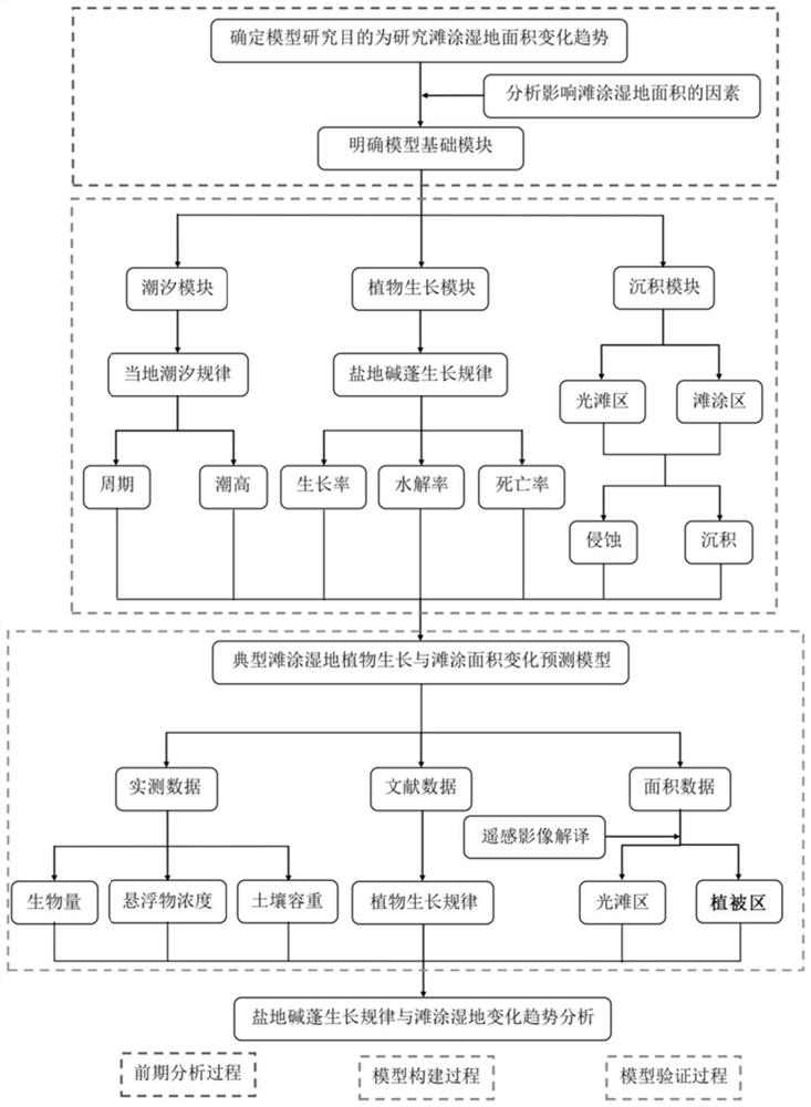
[0080] The present invention will be further described below in conjunction with specific embodiments.

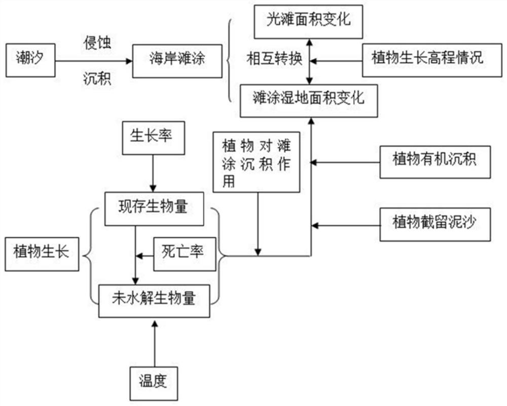
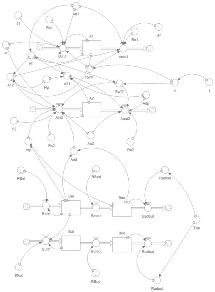
[0081] The present invention consists of three parts, such as figure 1 Shown: tidal model, plant growth model, and sedimentation model.

[0082] like figure 2 As shown, the tidal model mainly simulates the periodic tidal inundation of the intertidal zone. The plant growth model mainly simulates the annual changes in biomass and litter quality of typical annual vegetation in the intertidal zone and its impact on intertidal deposition. The sedimentary model simulates the intertidal wetland deposition and erosion dynamics process under the influence of tides and vegetation, and outputs area change data.

[0083] A method for predicting the future development trend of the intertidal zone area based on the intertidal zone area change model, the steps are as follows:

[0084] (1) Field investigation to confirm the main vegetation types in the intertidal zone, sampling to det...


PUM


Abstract

A method for predicting the future development trend of intertidal zone area based on an intertidal zone area change model, comprising the following steps: S1. Determine the growth rate, mortality rate and decomposition rate of plants according to the growth phenological characteristics and biomass data of a single vegetation According to the annual change trend, build a plant growth model; S2. According to the tidal water level, period and time data of big and small tides, get the tidal change equation in the region, and build a tidal model; S3. According to the multi-year area data in different regions of the region, and Erosion builds a dynamic model system and builds a sedimentary model; S4. According to the effect of tides on the intertidal zone and the effect of single annual vegetation growth on the intertidal zone, the tidal model, the plant growth model and the sedimentary model are coupled to form a completed The intertidal zone area change model is used to simulate and predict different areas of the intertidal zone.

Description

technical field [0001] The invention is a method for simulating and predicting the change of the wetland area in the intertidal zone based on the STELLA system dynamics software, in particular, it is suitable for simulating and predicting the wetland area in the intertidal zone with a single annual vegetation. Background technique [0002] Intertidal wetlands refer to areas that are sometimes submerged by water due to tidal action, and sometimes exposed to the water surface, and the upper part of the wetland is often exposed to the lower part of the water surface and is often submerged by water. [0003] As an ecosystem between waterway ecosystems, intertidal wetlands are characterized by fragility, primary productivity, and high biodiversity, and are an important part of the global ecosystem. Structure and function are closely related. Restoration of intertidal wetland area and vegetation plays an important role in restoration and ecosystem structure and function. Therefore...

Claims


Application Information

Patent Timeline
Patent Type & Authority Patents(China)
IPC IPC(8): G06Q10/04G06F30/20
CPCG06Q10/04
Inventor 刘玉虹陈琤陆滢
Owner HOHAI UNIV
Why Eureka
Try Eureka