Incremental farmland boundary precision calibration method and device with constraint point set registration
A technology of boundary accuracy and calibration method, applied in image enhancement, image data processing, instruments, etc., can solve the problems of difficult to widely use, high price of aerial survey drones, increased operation difficulty and operation cost, etc., and achieves the goal of improving positioning accuracy. Effect
- Summary
- Abstract
- Description
- Claims
- Application Information
AI Technical Summary
Problems solved by technology
Method used
Image
Examples
Embodiment 1
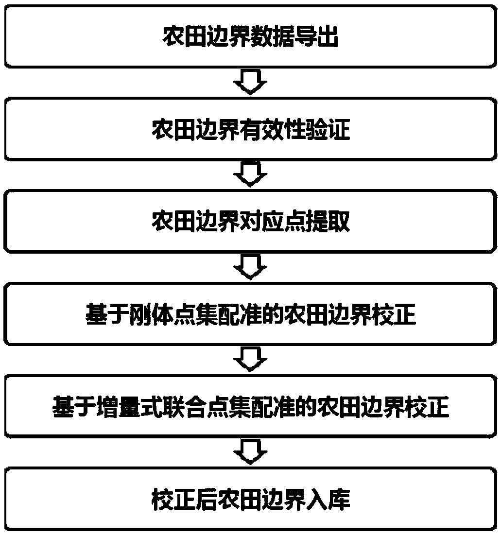
[0042] The present invention provides an incremental farmland boundary precision calibration method with constraint point set registration, the flow chart is as follows figure 1 As shown, it specifically includes the following steps:
[0043] Step 1, farmland boundary data export
[0044] The average positioning accuracy of satellite remote sensing images is at the meter level, that is, the deviation between the measured farmland boundaries and the farmland boundaries extracted based on satellite remote sensing images is generally at the meter level. This allows us to pair and organize the farmland boundary data extracted based on satellite remote sensing images and actual measurements based on the center of the farmland boundary and stored in the database in a reverse geocoding manner. According to the center position of the farmland obtained by actual measurement, the spatial search method can be used to search and extract the corresponding farmland boundary based on satell...
Embodiment 2
[0057] The present invention also provides an incremental farmland boundary precision calibration device with constraint point set registration, such as Figure 4 As shown, the device includes:
[0058] The farmland boundary data pairing and derivation unit is used to pair and store the data of the farmland boundary extracted based on the satellite remote sensing image and the data of the farmland boundary actually measured in the database, and export the data of the farmland boundary;
[0059] The validity verification unit of the farmland boundary is used to determine the validity of the extracted farmland boundary according to the shape similarity and regional overlap rate between the farmland boundary extracted based on the satellite remote sensing image and the farmland boundary obtained by actual measurement;
[0060] The corresponding point extraction and correction unit of the farmland boundary is used to extract the corresponding points of the farmland boundary, the f...
Embodiment 3
[0063] The present invention also provides a memory, the memory stores a computer program, and the computer program performs the following steps:
[0064] Pair and store the farmland boundary data extracted based on satellite remote sensing images with the actual measured farmland boundary data in the database, and export the farmland boundary data;
[0065] Determine the validity of the extracted farmland boundary based on the shape similarity and regional overlap rate between the farmland boundary extracted based on satellite remote sensing images and the actual measured farmland boundary;
[0066] Extract the corresponding points of the farmland boundary, the farmland boundary extracted based on the rigid body point set registration correction, and the farmland boundary extracted based on the incremental joint point set registration correction;
[0067] Store the corrected field boundaries in the database.
[0068] The present invention does not limit the computer language...
PUM
 Abstract
Description
Claims
Application Information
 - R&D
- Intellectual Property
- Life Sciences
- Materials
- Tech Scout
- Unparalleled Data Quality
- Higher Quality Content
- 60% Fewer Hallucinations
Browse by: Latest US Patents, China's latest patents, Technical Efficacy Thesaurus, Application Domain, Technology Topic, Popular Technical Reports.
© 2025 PatSnap. All rights reserved.Legal|Privacy policy|Modern Slavery Act Transparency Statement|Sitemap|About US| Contact US: help@patsnap.com


