
Gridding coding method for urban three-dimensional live-action data

A coding method and grid technology, applied in the field of geographic information, can solve the problems of high scalability of 3D data, slow loading and display of large scene data, and inability to efficiently exert the maximum value of 2D and 3D data, and achieve reasonable Effects of stitching, solving management and updating challenges

Active Publication Date: 2020-04-21
宝略科技(浙江)有限公司
View PDF16 Cites 4 Cited by
  • Summary
  • Abstract
  • Description
  • Claims
  • Application Information

AI Technical Summary

Problems solved by technology

These two types of data exist relatively in isolation, and cannot efficiently utilize the maximum value of two-dimensional and three-dimensional data, and the scalability of three-dimensional data is relatively higher than that of two-dimensional data
[0007] 3. The existing urban 3D real scene data is divided and stored according to the resolution level in the form of a tree structure. During the data call process, the index traverses the data of each resolution level under each oblique photographic data storage sub-file, so that the large scene data load Entry and display sluggish

Method used


Image

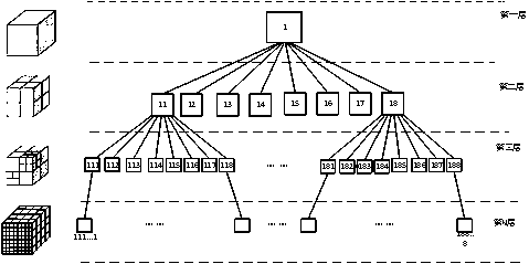
  • Gridding coding method for urban three-dimensional live-action data

Examples


Embodiment Construction

[0022] The present invention will be further described below through specific embodiments, but the present invention is not limited to the following specific embodiments.

[0023] A gridded encoding method for urban three-dimensional real-scene data, the urban three-dimensional real-scene data mainly includes oblique photographic data, and it comprises the following steps:

[0024] Segmentation, labeling, and storage of urban oblique photography data based on grid units and coordinate information of the southwest corner of the data

[0025] Based on the plane coordinates of the southwest corner of the urban oblique photographic data (the 2000 national plane coordinates of cities reset to the thousand digits), the data is divided into grid units, and the coordinate information of the southwest corner of the grid-divided data is coded and stored to realize the urban tilt Gridded encoding of photographic data. Among them, the grid unit adopts the integer multiple of the unit of ...


PUM


Abstract

The invention relates to the technical field of geographic information, in particular to a gridding coding method of urban three-dimensional live-action data. The method comprises the following steps:S1, acquiring an overall area of a three-dimensional real scene of a city, and gridding the overall area by taking one point of the overall area as an original point and using a set segmentation gridunit; S2, taking a point of a set position in each gridding after gridding as a position point, and then setting a grid name according to the coordinate of the position point of each gridding; and S3, setting a storage path of the city three-dimensional live-action data, enabling the subdirectory to comprise folders named by the grid names obtained in the step S2, and then storing the city three-dimensional live-action data into the corresponding grid name folders according to the grid position information obtained by the city three-dimensional live-action data. According to the method, the stored urban three-dimensional live-action data is enabled to carry geographic space recognition information.

Description

technical field [0001] The invention relates to the technical field of geographic information, in particular to a gridded coding method for urban three-dimensional real scene data. Background technique [0002] With the application and promotion of urban 3D real scene measurement technology in the surveying and mapping geographic information industry, this technology has promoted and produced a large number of urban 3D real scene data in different periods or different districts. However, the current urban 3D real scene data is divided and stored differently. Not only has it caused the problem of merging and updating urban 3D real-world data, but it has also caused problems in scheduling and popularizing applications at the derivative application level. [0003] Among the existing patents, the application number is CN201610217248.2, and the application name is: method and device for storing and scheduling oblique photography data. Specifically, it is proposed to divide and s...

Claims


Application Information

Patent Timeline
Patent Type & Authority Applications(China)
IPC IPC(8): G06F16/172G06F16/13G06F16/51
CPCG06F16/172G06F16/13G06F16/51Y02A30/60
Inventor 高广吴敦费佳宁应良中王倩
Owner 宝略科技(浙江)有限公司
Learn More