
Linear project GPS rapid lofting construction method

A construction method and engineering technology, applied in radio wave measurement systems, satellite radio beacon positioning systems, measurement devices, etc., can solve problems such as low work efficiency, inability to effectively cooperate to ensure on-site construction progress, etc., to improve efficiency and save money Construction cost and effect of reducing usage

Inactive Publication Date: 2019-11-05
CHINA HYDROPOWER ELEVENTH ENG BUREAU ZHENGZHOU CO LTD +1
View PDF7 Cites 0 Cited by
  • Summary
  • Abstract
  • Description
  • Claims
  • Application Information

AI Technical Summary

Problems solved by technology

When there are many construction tasks in each area, it cannot effectively cooperate to ensure the construction progress on site, and the overall work efficiency is low

Method used


Image

  • Linear project GPS rapid lofting construction method

Examples


Embodiment Construction

[0016] The present invention is described in further detail below by embodiment, and embodiment is only used for illustrating the present invention, does not limit the scope of the present invention.

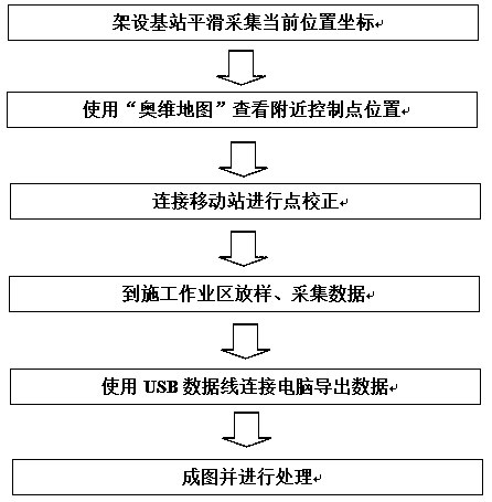
[0017] Such as figure 1 Shown is a linear engineering GPS rapid stakeout construction method, including the following steps:

[0018] (1) Set up the base station to smoothly collect the current position coordinates: set up the base station in the open area in the project department, check the location of nearby control points, use the "Ovi map" to check the location of nearby control points, and go to nearby control points for correction;

[0019] (2) Connect the mobile station for point calibration: For example, stake out the position of the bridge pile foundation, input the coordinates of the pile foundation, you can choose point stakeout or line stakeout, the speed of point stakeout is relatively fast, and the distance between two pile foundations can be known by line stakeou...


PUM


Abstract

The invention belongs to the technical field of water conservancy projects, and relates to a linear project GPS rapid lofting construction method. A base station is erected to collect current positioncoordinates smoothly, wherein the base station is erected in an open area at a project department, positions of nearby control points are checked, and point correction is conducted at the nearby control points; the base station is connected with a mobile station for point correction, for example, the bridge pile foundation position is subjected to lofting, pile foundation coordinates are input, and point lofting or linear lofting can be selected; lofting and data collection are carried out in a lofting area, wherein a USB data line is connected with a computer to export data, the data of thecurrent area is collected to ensure the correctness of the data, when the USB data line is connected with the computer for transmission, data exchange is conducted, and the data is copied and importedto the computer; images are formed and processed, wherein collected dat document data is loaded for required data processing. The method has the advantages that rapid accurate construction lofting isachieved; the lofting efficiency is improved, and the requirement of the construction progress of a site is met; the number of workers is reduced, and the workload of measuring personnel is reduced;the construction cost is reduced.

Description

technical field [0001] The patent of the invention belongs to the technical field of water conservancy engineering, and relates to a construction method of GPS rapid stakeout for linear engineering. Background technique [0002] The efficiency of using the total station for construction and setting out in linear engineering is relatively low. Because the total station erection, backsight, and station setup take a long time, whether it can work normally depends on whether the instrument meets the condition of visibility. The use of the total station is limited. The geographical environment has a greater influence. There must be visible light, and the light cannot be too weak, because although the total station can automatically measure coordinates, elevation, distance, and angle. However, it also requires the human eye to actively aim at the target. If there is no light or the light is too weak, it is difficult for the human eye to find the observation target. The earthwork...

Claims


Application Information

Patent Timeline
Patent Type & Authority Applications(China)
IPC IPC(8): G01S19/42G01C15/02
CPCG01C15/02G01S19/42
Inventor 巩华威吴峡民范兴利宗春孙力野
Owner CHINA HYDROPOWER ELEVENTH ENG BUREAU ZHENGZHOU CO LTD
Learn More