Coastal city multi-source flood numerical simulation method based on GIS grid operation
A numerical simulation and flood technology, applied in computing, ICT adaptation, data processing applications, etc., can solve the problem of being unable to simultaneously realize the simulation of storm and waterlogging scenarios, and achieve the effect of simple operation and efficient calculation
- Summary
- Abstract
- Description
- Claims
- Application Information
AI Technical Summary
Problems solved by technology
Method used
Image
Examples
Embodiment Construction
[0059] The present invention will be described in detail below in conjunction with the accompanying drawings and embodiments.
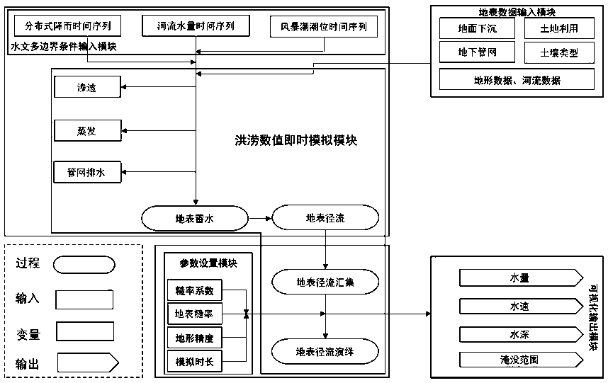
[0060] refer to figure 1 , the present invention is provided with parameter setting module, surface data input module, hydrological multi-boundary condition input module, flood numerical instant simulation module and visual output module; The meaning of each module:
[0061] Parameter setting module: this module sets the necessary parameters for the simulation scenario, which is set according to the actual situation of the research area;
[0062] Hydrological multi-boundary condition input module: This module inputs the flood scenarios that need to be simulated (rainstorm and internal waterlogging, storm surge, river flood), which can be a single disaster flood or multiple flood scenarios;
[0063] Surface data input module: This module inputs the actual surface data of the research area, including terrain and river data. land subsidence, land use, so...
PUM
 Abstract
Description
Claims
Application Information
 - R&D
- Intellectual Property
- Life Sciences
- Materials
- Tech Scout
- Unparalleled Data Quality
- Higher Quality Content
- 60% Fewer Hallucinations
Browse by: Latest US Patents, China's latest patents, Technical Efficacy Thesaurus, Application Domain, Technology Topic, Popular Technical Reports.
© 2025 PatSnap. All rights reserved.Legal|Privacy policy|Modern Slavery Act Transparency Statement|Sitemap|About US| Contact US: help@patsnap.com


