A 3D stratigraphic information visualization method based on mobile terminal

A mobile terminal and three-dimensional formation technology, applied in image analysis, instruments, calculations, etc., can solve the problems of single display information and complex realization, achieve comprehensive and rich information, improve convenience and efficiency, and realize fast/real-time visualization Effect

Active Publication Date: 2021-10-22
WUHAN UNIV
View PDF5 Cites 0 Cited by
  • Summary
  • Abstract
  • Description
  • Claims
  • Application Information

AI Technical Summary

Problems solved by technology

[0007] In view of this, the present invention provides a mobile terminal-based three-dimensional formation information visualization method to solve or at least partially solve the technical problems of single display information and relatively complex implementation in the methods in the prior art

Method used


Image

  • A 3D stratigraphic information visualization method based on mobile terminal
  • A 3D stratigraphic information visualization method based on mobile terminal
  • A 3D stratigraphic information visualization method based on mobile terminal

Examples


Embodiment 1

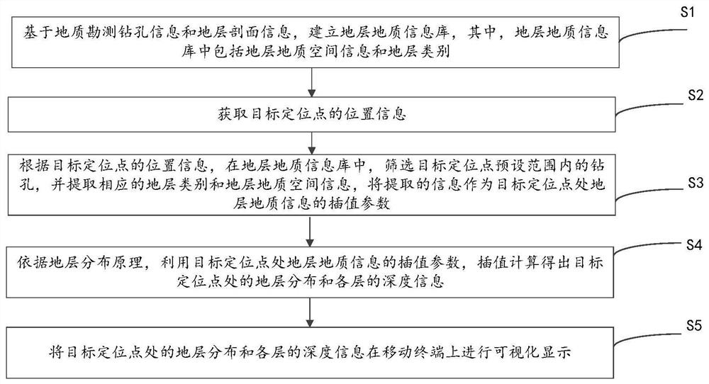
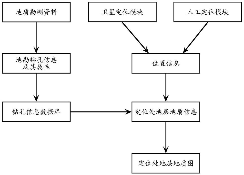
[0037] Through a lot of practice and research, the invention of this application finds that: due to the need for fast or real-time stratum acquisition of geological information in the current engineering site survey and decision-making, and the geological information demand may be for the underlying position of any coordinate of the engineering site, the current It is difficult to meet the information acquisition needs of actual engineering site survey and decision-making with advanced technical means.

[0038] With the popularization of handheld smart devices, smart terminals are equipped with satellite positioning modules (GPS or "Beidou Satellite Navigation System"), which can conveniently realize reconnaissance and positioning. Therefore, the present invention combines positioning technology, stratum information system and stratum information visualization technology to realize real-time dynamic positioning and display of stratum information, which can greatly facilitate th...


PUM


Abstract

The invention discloses a three-dimensional formation information visualization method based on a mobile terminal. First, establish the stratum geological information database, and obtain the position information of the target positioning point; then, according to the position information of the target positioning point, in the stratum geological information database, screen the boreholes within the preset range of the target positioning point, and extract the corresponding stratum category and stratum geological space information; then according to the stratum distribution principle, using the interpolation parameters of the stratum geological information at the target positioning point, the interpolation calculation obtains the stratum distribution at the target positioning point and the depth information of each layer; finally, visualize on the mobile terminal show. The invention establishes stratum distribution information database based on geological drilling exploration data. A stratum visualization method based on a mobile terminal is provided. Taking the Android-based smart mobile terminal as an example, the convenient extraction and visualization of formation information at the positioning point is realized. It has great application and promotion value in the field of engineering.

Description

technical field [0001] The invention relates to the field of computer application technology, in particular to a three-dimensional formation information visualization method based on a mobile terminal. Background technique [0002] Stratigraphic geological information is the basic condition for determining the foundation reinforcement measures and investment of civil engineering, including the distribution characteristics of the lithology of the subsurface where the project site is located, the thickness and depth of the stratum, and so on. Therefore, for civil engineering, it is necessary to obtain the geological stratigraphic information of the foundation of the construction site. [0003] In order to obtain geological and stratigraphic information, computer means are often used to construct three-dimensional stratigraphic models to express stratigraphic geological information. [0004] In the process of implementing the present invention, the inventor of the present appl...

Claims


Application Information

Patent Timeline
Patent Type & Authority Patents(China)
IPC IPC(8): G06T17/05G06T7/70G06T7/50
CPCG06T17/05G06T7/50G06T7/70
Inventor 刘全宋子达张路马伟超周延张乐张志豪王浩
Owner WUHAN UNIV
Why Eureka
Try Eureka