
Inversion method of multi-layer cloud by multi-channel scanning imaging radiometer of Fengyun-4a meteorological satellite

A meteorological satellite, scanning imaging technology, applied in the field of satellite remote sensing, can solve the problems of incomplete reference and difficult to provide product data by quantitative remote sensing, and achieve the effect of efficient multi-layer cloud detection results

Active Publication Date: 2021-11-02
NANJING UNIV OF INFORMATION SCI & TECH
View PDF11 Cites 0 Cited by
  • Summary
  • Abstract
  • Description
  • Claims
  • Application Information

AI Technical Summary

Problems solved by technology

However, the current multi-layer cloud algorithms still have great uncertainty, and it is difficult to provide accurate product data for subsequent quantitative remote sensing
Moreover, due to changes in spectral channels, the development of my country's AGRI / FY-4A cloud products, especially multi-layer cloud products, cannot fully refer to existing mature algorithms

Method used


Image

  • Inversion method of multi-layer cloud by multi-channel scanning imaging radiometer of Fengyun-4a meteorological satellite
  • Inversion method of multi-layer cloud by multi-channel scanning imaging radiometer of Fengyun-4a meteorological satellite

Examples


specific Embodiment approach

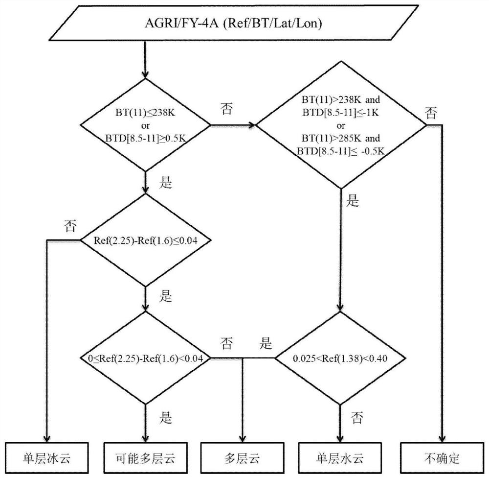
[0023] (1) Based on the multi-spectral threshold cloud detection algorithm developed by the National Satellite Meteorological Center based on the meteorological satellite wind and cloud 3D (FY-3D) imager MERSI-II, develop and optimize the cloud identification algorithm suitable for AGRI / FY-4A. Using the AGRI / FY-4A data, according to the cloud detection products obtained by the cloud detection algorithm based on multi-spectral threshold, determine the cloudy or clear sky conditions of each pixel, which are divided into four categories: cloudy, likely cloudy, clear sky, and possibly clear sky. AGRI / FY-4A data used in the present invention (such as figure 1 , where Ref(1.6) and Ref(2.25) represent the reflectivity of 1.6 and 2.25 μm channels respectively, BT(8.5) and BT(11) represent the brightness temperature of 8.5 and 11 μm channels respectively, and BTD[8.5-11] represents the 8.5 and 11 μm channels 11 μm channel brightness temperature difference, Lon and Lat represent longitu...


PUM


Abstract

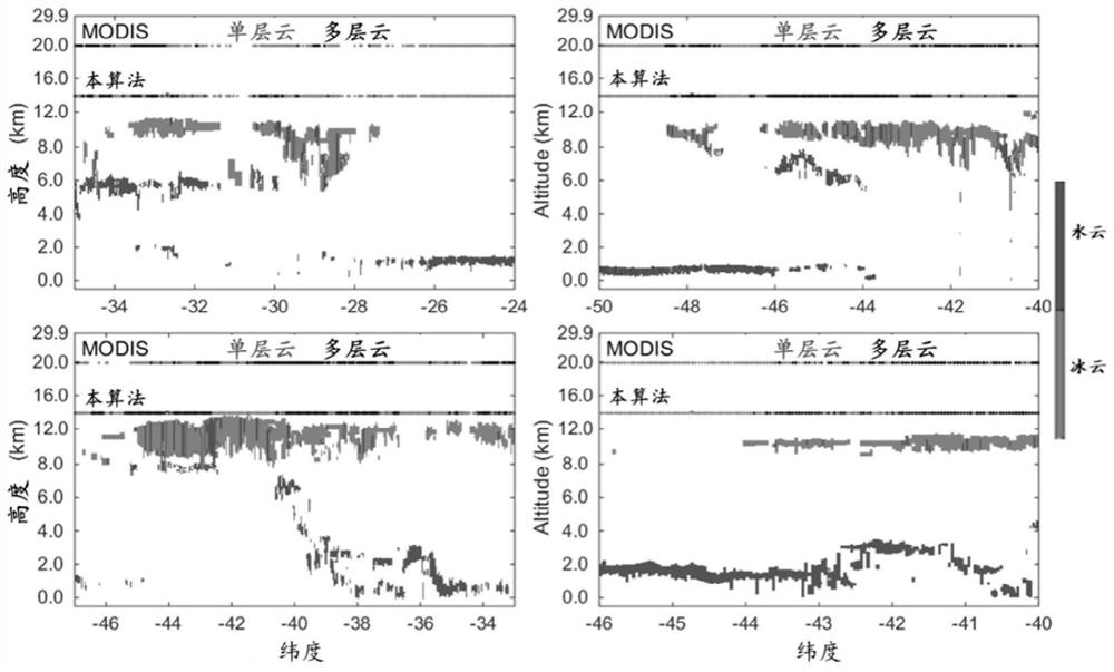
The invention discloses a multi-layer cloud inversion method of a multi-channel scanning imaging radiometer of Fengyun 4A meteorological satellite, which fills up the blank of the domestic algorithm. Fully considering the unique spectral channel design characteristics of the domestic satellite radiometer AGRI, based on the rapid radiative transfer simulation as the theoretical basis, a multi-layer cloud model was established to analyze the sensitivity of different short-wave infrared channels (1.6 and 2.25 μm) to different phase clouds, For the first time, it is found that these two channels can be used to identify cloud phase states. The model verified that under different cloud optical thicknesses, the penetrating power of the short-wave infrared channel is better, and the information of the lower water cloud can pass through the upper ice cloud and be extracted from satellite observations. Combined with the identification of the cloud top phase state by the infrared channel, a new identification algorithm for radiometer observation of multilayer clouds (upper ice clouds and lower water clouds) is finally proposed. The multilayer cloud results of this algorithm are verified by using the accurate active spaceborne lidar CALIOP, which has good accuracy. The invention fully considers the unique spectral channel design characteristics of my country's imager, and is used for my country's new generation of imager AGRI, which can provide more accurate and efficient multi-layer cloud detection results for future business applications.

Description

technical field [0001] The invention belongs to the field of satellite remote sensing, in particular to a multi-layer cloud inversion method for a multi-channel scanning imaging radiometer of a Fengyun 4A meteorological satellite. Background technique [0002] At present, almost all inversions of cloud optical and microphysical properties at home and abroad are based on the monolayer cloud assumption, that is, it is assumed that a single layer of clouds has the same physical properties, but there are often multi-layered clouds in the actual atmosphere. The importance of multilayer clouds is not only reflected in its large frequency of occurrence on a global scale, but also affects the inversion effect of cloud characteristics on the incident solar radiation and the earth's emitted radiation. Meteorological satellites have the advantages of crossing national boundaries and global coverage, and are the main method to obtain the global temporal and spatial distribution of cloud...

Claims


Application Information

Patent Timeline
Patent Type & Authority Patents(China)
IPC IPC(8): G01N21/17G01N21/3504
Inventor 刘超王健捷姚彬王金虎
Owner NANJING UNIV OF INFORMATION SCI & TECH
Learn More