
Asteroid surface optical navigation road sign evaluation selection method

A surface optics, asteroid technology, applied in the directions of integrated navigators, navigation calculation tools, measurement devices, etc., can solve the problems such as the inaccuracy of the independent selection method of navigation road signs and the lack of consideration of the influence of the uncertainty of the crater center.

Active Publication Date: 2019-05-03
BEIJING INSTITUTE OF TECHNOLOGYGY
View PDF9 Cites 5 Cited by
  • Summary
  • Abstract
  • Description
  • Claims
  • Application Information

AI Technical Summary

Problems solved by technology

[0008] The existing method for selecting navigation landmarks for deep space probes does not consider the influence of the uncertainty of the crater center, which leads to the problem that the independent selection method of navigation landmarks is not accurate enough

Method used


Image

  • Asteroid surface optical navigation road sign evaluation selection method
  • Asteroid surface optical navigation road sign evaluation selection method
  • Asteroid surface optical navigation road sign evaluation selection method

Examples


Embodiment Construction

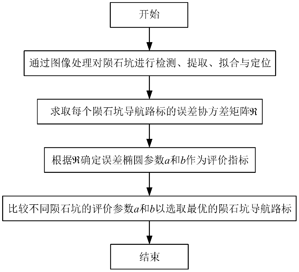
[0057] In order to better illustrate the purpose and advantages of the present invention, the content of the invention will be further described below in conjunction with the accompanying drawings and examples.

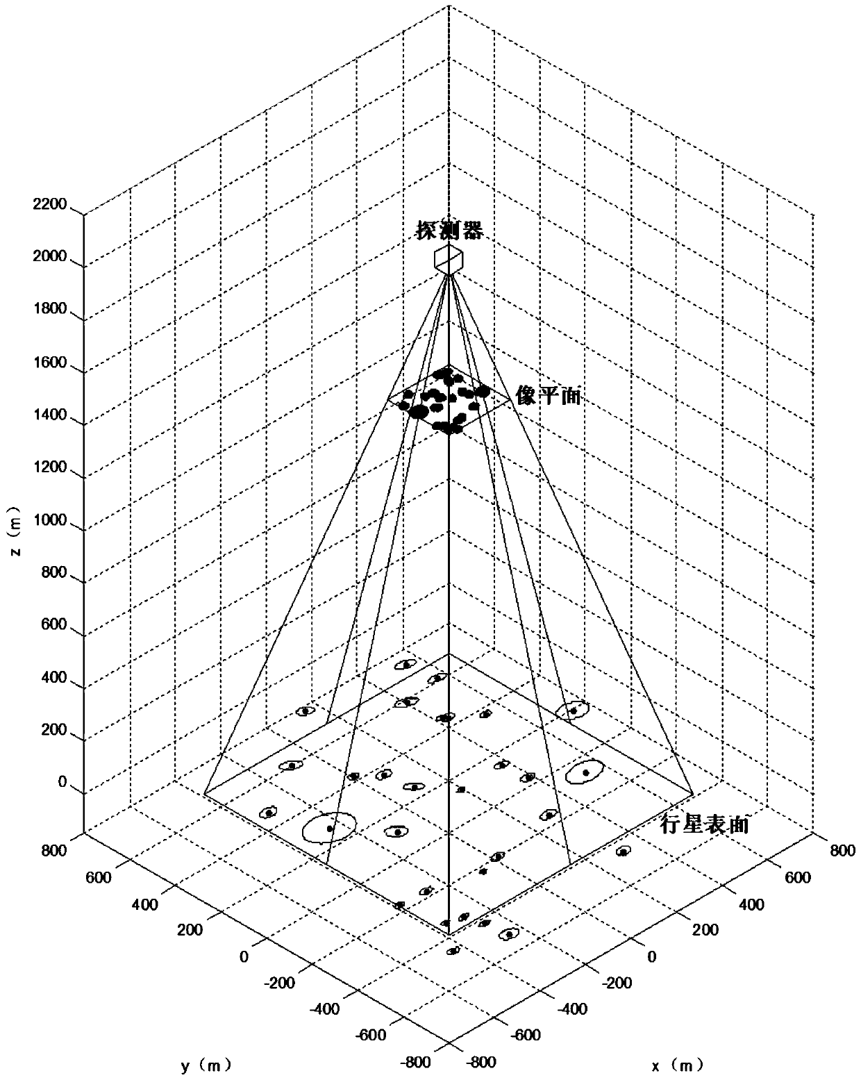
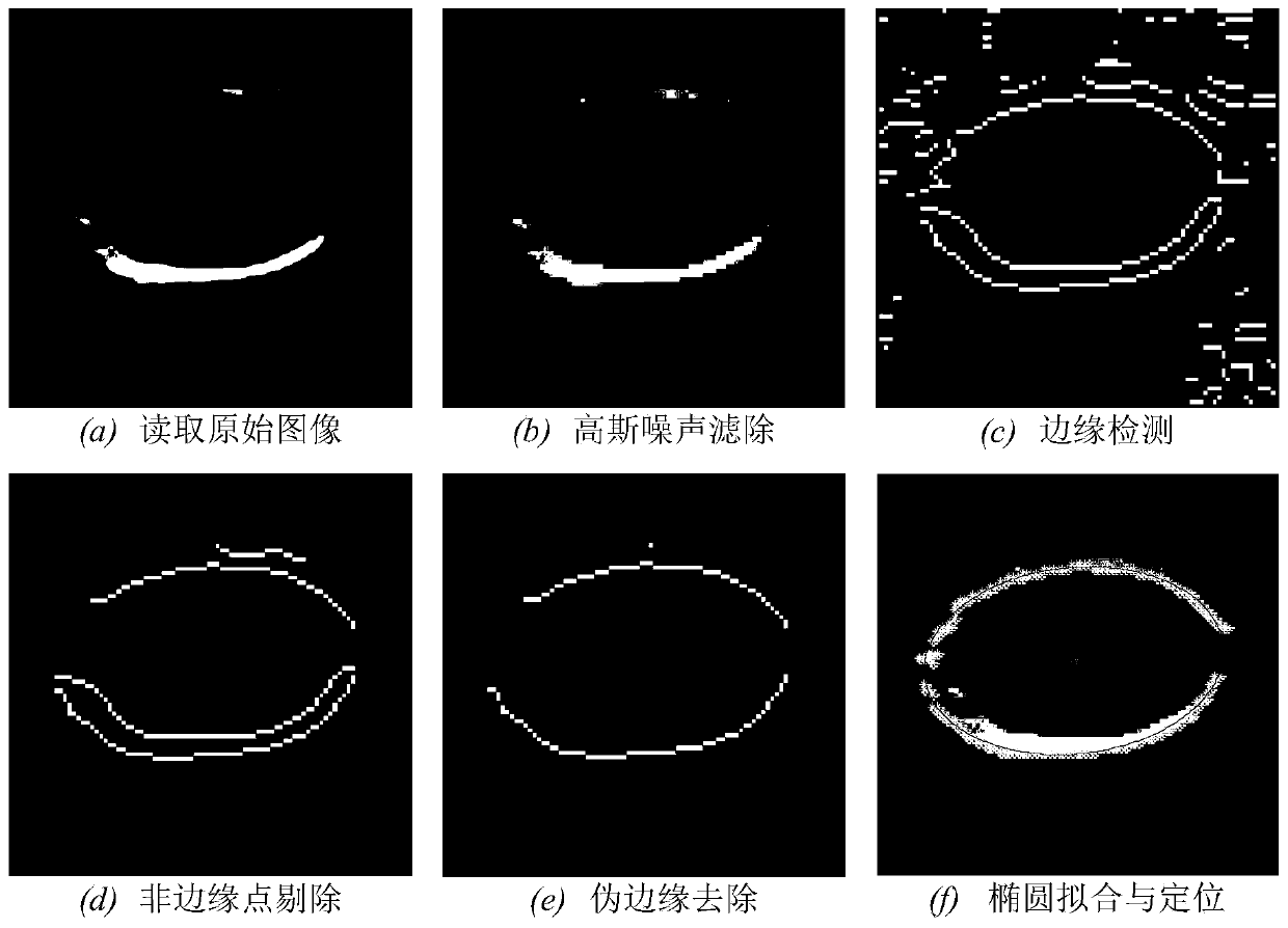
[0058] In order to verify the feasibility of the present invention, the image information of the crater on the surface of the asteroid Eros 433 is used to draw the result and the fitting ellipse of the crater on the original map through image processing, as Figure 4 As shown in (b), and define the three-dimensional coordinates of each crater navigation landmark in the small celestial body fixed coordinate system, the initial position of the detector in the small celestial body fixed coordinate system is [500; -300; 2000] meters, the initial attitude is [5; -10; 30] degrees. The field of view is 30 degrees, the focal length of the navigation camera is f=8mm, and mathematical simulation verification is carried out.

[0059] The method for evaluating and selecting land...


PUM


Abstract

The invention discloses an asteroid surface optical navigation road sign evaluation selection method, is especially suitable for a navigation system which uses meteor craters as road signs to autonomously determine the position and the attitude of a deep space detector and belongs to the field of autonomous navigation. The method is characterized in that the image processing algorithm is utilizedin navigation camera images to detect and extract the asteroid surface meteor crater information; elliptic fitting and meteor crater center positioning are performed on the detected meteor crater information; a fitted elliptic equation is utilized, according to the uncertainty propagation characteristics, an error covariance matrix R of the meteor crater is obtained, and error elliptic long and short half axes a and b describing the uncertainty of crater errors are obtained as indexes for evaluating the observation quality of the meteor crater. The accurate and feasible positioning road sign autonomous selection method is provided for the deep space detector, the best navigation road signs are selected, so accuracy of navigation road sign selection of the deep space detector is improved, and thereby navigation accuracy of the position and the attitude of the deep space detector is improved.

Description

technical field [0001] The invention relates to an evaluation and selection method for optical navigation landmarks of deep-space probes on the surface of irregular asteroids, and is particularly suitable for a navigation system that uses craters as landmarks to independently determine the position and attitude of deep-space probes, and belongs to the field of autonomous navigation. Background technique [0002] Flying near the target celestial body will be one of the core tasks of deep space exploration in the future. The voyage of deep space exploration is far away and takes a long time, and the traditional measurement and control method has a large communication delay. In addition, the dynamic environment of deep space is complex, and the traditional navigation and control mode based on ground remote control can no longer meet the needs of high-precision detection, which requires the detector to have an autonomous navigation function. Although traditional inertial navigat...

Claims


Application Information

Patent Timeline
Patent Type & Authority Applications(China)
IPC IPC(8): G01C21/20G01C21/24G01C25/00
Inventor 朱圣英修义崔平远徐瑞
Owner BEIJING INSTITUTE OF TECHNOLOGYGY
Learn More