A river measuring method based on three-dimensional reconstruction

A technology of three-dimensional reconstruction and measurement method, which is applied in the field of measurement, can solve the problems of long time consumption, low precision, and high difficulty of operation, and achieve the effect of reducing measurement cost and making it easy to obtain

Pending Publication Date: 2019-04-23
YANGZHOU UNIV
View PDF5 Cites 0 Cited by
  • Summary
  • Abstract
  • Description
  • Claims
  • Application Information

AI Technical Summary

Problems solved by technology

[0003] The purpose of the present invention is to propose a river engineering measurement method based on three-dimensional reconstruction, which solves the problems of high operational difficulty, long time-consuming, and low precision in the existing river engineering experimental model terrain measurement

Method used


Image

  • A river measuring method based on three-dimensional reconstruction
  • A river measuring method based on three-dimensional reconstruction
  • A river measuring method based on three-dimensional reconstruction

Examples


Embodiment

[0044] The specific steps of the river surveying method based on 3D reconstruction are as follows:

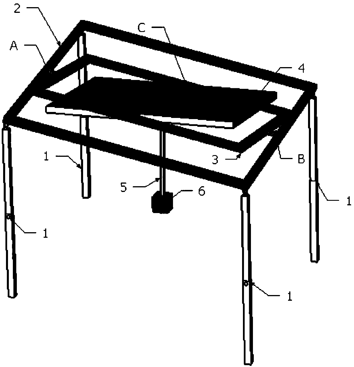
[0045] Step 1, such as figure 1 As shown, establish a coordinate system on the level and mark several coordinate points. The spirit level includes four supports 1, an outer frame 2, an inner frame 3, a flat plate 4 and a lead weight 6, and the four supports 1 are respectively arranged on the four corners of the lower surface of the outer frame 2 and can be rotated and locked around the corners respectively. The inner frame 3 is arranged inside the outer frame 2 and can rotate around one of its midlines. The flat panel 4 is arranged inside the inner frame 3 and can rotate around a midline perpendicular to the midline of rotation of the inner frame 3. The geometric center of the flat panel 4 is A lead block hangs below. The four brackets can rotate freely to adapt to complex terrain. The inner frame and the outer frame are connected by bearings at point A and point B, so that t...


PUM


Abstract

The invention provides a river measuring method based on three-dimensional reconstruction, which comprises the following steps of firstly, establishing a coordinate system on a level gauge horizontalplate, and marking a plurality of coordinate points; then placing the level gauge at any position of the terrain to be measured, shooting a plurality of photos of the terrain to be measured from a plurality of angles and a plurality of distances, wherein at least ten photos comprise the level gauge; secondly, importing the shot pictures into visalSFM software, finding out all the pictures containing the gradienter in the software, and inputting marked coordinate points in each picture containing the gradienter; using the visual SFM software to restore the shooting position of the camera through calculation, and construct a to-be-detected terrain three-dimensional model according to the picture; and finally, dividing the to-be-measured area into grids, and interpolating points of the to-be-measured terrain three-dimensional model to the divided grid points to obtain a final river work model. According to the invention, through the mutual verification of a large number of points, a high-precision measurement result is provided.

Description

technical field [0001] The invention belongs to measurement technology, in particular to a river engineering measurement method based on three-dimensional reconstruction. Background technique [0002] For the measurement of water conservancy models, there are many deficiencies in the traditional measurement methods commonly used at present, mainly in the following aspects: (1) Since indoor experiments generally use terrain-forming materials, such as fly ash, etc., the materials are relatively soft. In some cases, if you continue to use elevation benchmarks to measure, it is easy to destroy the formed terrain due to the weight of the benchmarks, or produce a slight subsidence, which will affect the validity and accuracy of the measurement data; (2) Secondly, due to the space constraints of indoor conditions, physical The elevation scale of the test has a small measurement range and high precision requirements. Generally, the millimeter level is selected. Traditional measureme...

Claims


Application Information

Patent Timeline
Patent Type & Authority Applications(China)
IPC IPC(8): G06T7/55G06T3/40G06T17/05G01C15/14
CPCG06T3/4038G06T7/55G06T17/05G01C15/14G06T2207/10004G06T2207/30181Y02A20/402
Inventor 许仁义陈岗曹辉徐文涛罗和成刘杰钟强
Owner YANGZHOU UNIV
Why Eureka
Try Eureka