High-precision image map online construction method and device based on WebGIS and deep learning

A technology of image map and deep learning, applied in the field of geographic information science, can solve the problem of insufficient resolution of image map

Active Publication Date: 2019-04-16
CHINA UNIV OF GEOSCIENCES (WUHAN)
View PDF3 Cites 5 Cited by
  • Summary
  • Abstract
  • Description
  • Claims
  • Application Information

AI Technical Summary

Problems solved by technology

[0003] The technical problem to be solved by the present invention is to provide a high-precision image based on WebGIS and deep learning in view of the technical defect of insufficient image map resolution in the prior art Map online construction method

Method used


Image

  • High-precision image map online construction method and device based on WebGIS and deep learning

Examples


Embodiment Construction

[0034] In order to have a clearer understanding of the technical features, purposes and effects of the present invention, the specific implementation manners of the present invention will now be described in detail with reference to the accompanying drawings.

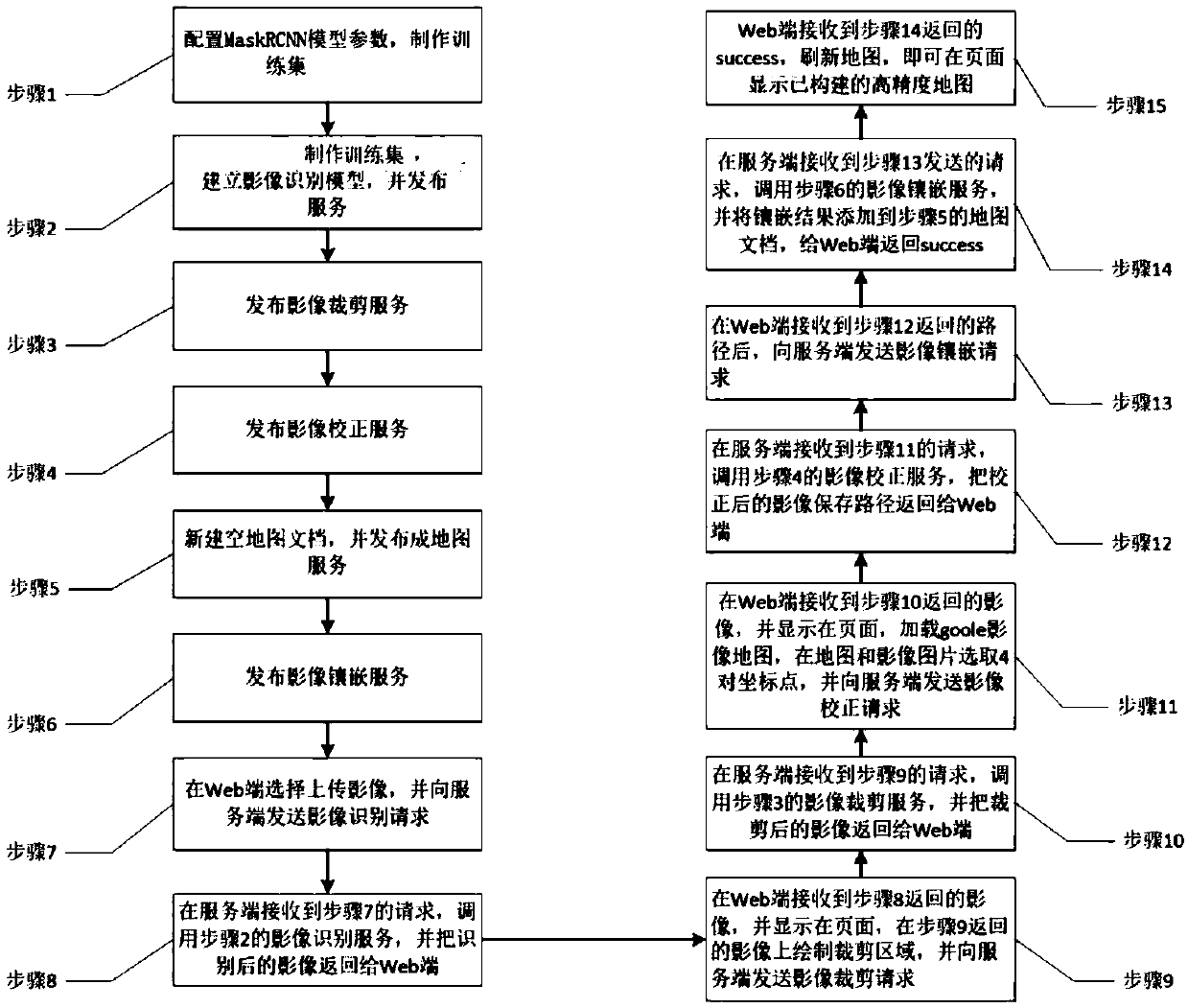
[0035] refer to figure 1 , which is a flowchart of an embodiment of the online construction method of high-precision image map based on WebGIS and deep learning of the present invention. In this implementation, the online construction method includes:

[0036] Step (1), collect the images of the construction map area, and configure the MaskRCNN model parameters according to the types of features in the collected images: label name class_names=['road', 'meadow', 'lake', 'basketball_court' ,'parkingspace'], picture size IMAGE_MIN_DIM=512#128, IMAGE_MAX_DIM=512#128, use the labeling software labelme to mark the target to be recognized in the picture, such as roads, grasslands, ponds, basketball courts, parking spaces. Th...


PUM


Abstract

The invention discloses a high-precision image map online construction method and device based on WebGIS and deep learning. The method comprises the following steps: calling an image recognition service to realize online recognition of an image picture ground object type; calling an image cutting service to realize online cutting of the image picture according to the image recognition result; calling an image correction service to realize image and picture online correction according to the image and picture cutting result; and according to an image correction result, calling an image inlayingservice to realize online inlaying of the image, thereby realizing online construction of a high-precision influence map. According to the invention, a terminal user uploads a photo shot by himself / herself; gradually carrying out on-line identification on the image picture; On-line cutting of images and pictures and on-line geometric correction and inlaying of the images and the pictures are carried out, so that on-line construction of a high-precision image map is completed, and through long-term maintenance and updating, centimeter-level spatial resolution, data open sharing and user collaborative editing can be constructed at low cost, and a small-range even global image map which can be updated on line in real time can be constructed.

Description

technical field [0001] The invention relates to the field of geographic information science, in particular to a method and device for online construction of high-precision image maps based on WebGIS and deep learning. Background technique [0002] As we all know, image maps around the world are all satellite images. When using image maps, you will find that the satellite images provided by most map manufacturers are not very clear. For example, the visibility of a building, a piece of grass and other ground objects on the image map is It is relatively low, and the definition is different in different regions around the world, because satellite images with different resolutions are used. What data to use and how much data to use are mainly determined based on demand and cost. GoogleEarth / Map is generally only up to level 20 in China, and the resolution is usually at the meter level. This data is on a global scale and free, so anywhere, there is only a meter-level resolution....

Claims


Application Information

Patent Timeline
IPC IPC(8): G06T11/00G06T7/73G06F16/29
CPCG06T7/75G06T11/001
Inventor 郭明强耿振坤黄颖余仲阳赵延毫盖涛
Owner CHINA UNIV OF GEOSCIENCES (WUHAN)
Why Eureka
Try Eureka