Sea-land integrated calibration field layout method for verifying dual-frequency LiDAR detector

A detector and calibration technology, which is applied in the direction of instruments, measuring devices, electromagnetic wave reradiation, etc., can solve the problem that LiDAR detector seabed topographic measurement technology cannot accurately verify the accuracy, and achieve the effect of promoting development and ensuring accuracy

Active Publication Date: 2019-04-12
广西壮族自治区遥感信息测绘院
View PDF7 Cites 3 Cited by
  • Summary
  • Abstract
  • Description
  • Claims
  • Application Information

AI Technical Summary

Problems solved by technology

[0003] Aiming at the problem that the LiDAR detector seabed topographic measurement technology cannot accurately verify the accuracy, the present invention provides a method for laying out the sea-land integrated calibration field

Method used


Image

  • Sea-land integrated calibration field layout method for verifying dual-frequency LiDAR detector
  • Sea-land integrated calibration field layout method for verifying dual-frequency LiDAR detector
  • Sea-land integrated calibration field layout method for verifying dual-frequency LiDAR detector

Examples


Embodiment Construction

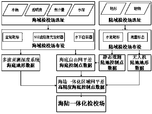
[0011] see figure 1 The shown dual-frequency LiDAR detector sea and land inspection field layout method flow chart, the following for each step in the embodiment process, the method of the present invention is described in further detail.

[0012] Step 1. The measurement accuracy of the dual-frequency LiDAR detector is closely related to the water quality. In order to better verify the accuracy of the detector, a typical area needs to be selected as the calibration field. Use the transparency disc, water color meter, and depth sounder to measure the transparency, water color and depth data of different areas in the waters near Weizhou Island in the North Sea, and take samples in each area to measure the sand content, salinity and PH value data of the sea water . Based on all the measured hydrological environment data, a 10km × 21km sea area is selected as the sea area calibration site for subsequent verification of the accuracy of the detector. First of all, several targets ...


PUM


Abstract

The invention discloses a sea-land integrated calibration field layout method for verifying a dual-frequency LiDAR detector, including the following steps: 1, collecting hydrological environment parameters in a near sea area range, and selecting a sea area calibration field from the near sea area range; manufacturing multiple targets as control points and evenly placing the targets on the seabed;arranging laser transmitters at the seabed, and also placing a transponder at the center; 2, surveying the three-dimensional coordinates of the control points of the seabed and the seabed topographicdata; 3, establishing a land area calibration field, arranging targets as control points inside the land area calibration field, 4, carrying out block adjustment on the coordinate information of the control points obtained in the step 3 and the terrain data of the sea-land calibration field surveyed in the step 2, obtaining the terrain data and unifying the coordinate datum, thereby constructing asea-land integrated calibration field. The method can accurately ensure the accuracy of topography scanned by the LiDAR detector, so as to meet the requirements of submarine topography survey of theLiDAR detector.

Description

technical field [0001] The invention belongs to the technical field of marine topography surveying and mapping, and in particular relates to a method for laying out a sea-land integrated calibration field for verifying a dual-frequency LiDAR detector. Background technique [0002] At present, the use of dual-frequency laser radar (LiDAR) detectors to measure seabed topography can only rely on other related technologies to verify the accuracy of the measured seabed topography data, which is limited by other technologies and cannot be well verified. The accuracy of the high-frequency LiDAR detector for seabed topography measurement also indirectly affects the development of LiDAR seabed topography measurement technology. Therefore, how to accurately ensure the accuracy of the LiDAR detector scanning the terrain to meet the requirements of the LiDAR detector's seabed topographic measurement is a problem that we need to solve urgently. Contents of the invention [0003] Aimin...

Claims


Application Information

Patent Timeline
IPC IPC(8): G01S17/89G01S7/497
CPCG01S7/497G01S17/89Y02A90/30
Inventor 刘润东周国清余万东范城城刘清吕华权赵学松黄友菊李彬黎珍惜施宇军李韬业
Owner 广西壮族自治区遥感信息测绘院
Why Eureka
Try Eureka