
Positioning system and positioning method which can be used indoors

A positioning method and technology for positioning services, applied in the field of indoor positioning systems, can solve the problems of positioning accuracy deviation, no obstruction, and uncontrollable network transmission time.

Active Publication Date: 2019-04-05
BORUITAIKE SCI & TECH NINGBO CO LTD
View PDF7 Cites 5 Cited by
  • Summary
  • Abstract
  • Description
  • Claims
  • Application Information

AI Technical Summary

Problems solved by technology

[0008] The disadvantages of UWB are: 1). A complete positioning network is required, and the support of 3 positioning base stations is required at any positioning point. If the number of base stations is reduced, the positioning accuracy will be greatly affected; 2). Obstacles that block radio transmission; 3). The basis of UWB positioning is that the base station needs to be synchronized, and even a slight network out-of-sync will lead to a relatively large deviation in positioning accuracy
[0020] GNSS signals are not available indoors, and the network and base stations are used to forward GNSS signals. Due to network jitter and congestion, the network transmission time is uncontrollable, and it is also unavailable; A-GPS technology combined with satellite positioning technology and base station-assisted positioning technology is for The dependence on GNSS is too high. When there is no satellite signal, A-GPS has actually degenerated into base station positioning (LBS positioning), and the positioning accuracy is far from meeting the general application requirements; most of the existing local positioning technologies have put forward New requirements, single function and high networking cost, so the feasibility is relatively poor

Method used


Image

  • Positioning system and positioning method which can be used indoors
  • Positioning system and positioning method which can be used indoors
  • Positioning system and positioning method which can be used indoors

Examples


Embodiment Construction

[0120] Specific implementations of the present invention will be provided below. It should be noted that the specific implementations described in this specification are only intended to illustrate the gist of the present invention, and do not constitute limitations on the protection scope of the present invention.

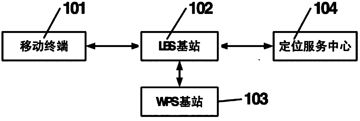
[0121] A preferred embodiment of the present invention discloses a positioning system that can be used indoors, which mainly consists of the following four parts, such as figure 1 Shown: mobile terminal 101, LBS base station 102, WPS base station 103, positioning service center 104, mobile terminal 101 and LBS base station 102 can communicate with each other, LBS base station 102 and positioning service center 104 can communicate with each other, WPS base station 103 It can communicate with the LBS base station 102. The mobile terminal 101 is the user's handheld terminal, the mobile terminal 101 is connected to the positioning service center 104 through the LBS ba...


PUM


Abstract

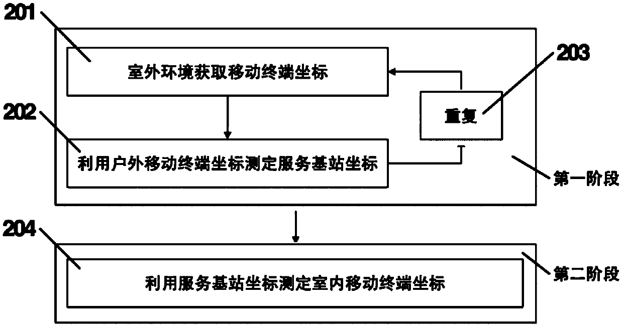
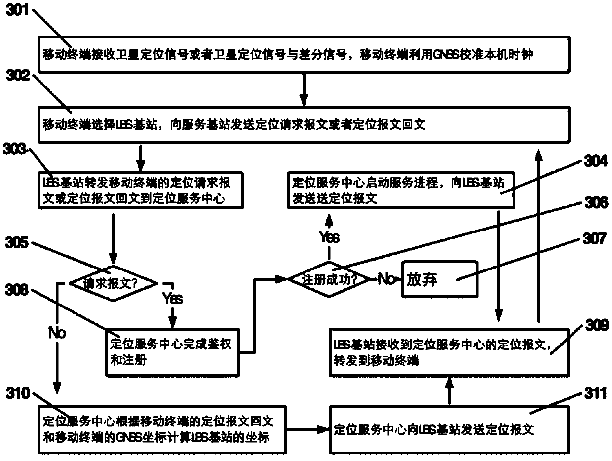
The invention discloses a positioning system and positioning methods which can be used indoors. A method comprises the steps of S1, measuring a LBS (Location Based Service) base station coordinate, specifically, obtaining a mobile terminal GNSS (Global Navigation Satellite System) coordinate based on GNSS signal positioning features through utilization of an outdoor environment, sending a positioning request message by a mobile terminal to a positioning service center, sending a positioning message by the positioning service center to the mobile terminal, sending a positioning message reply message, computing the positioning message reply message to obtain a pseudo range from the mobile terminal to an LBS base station, and computing the LBS base station coordinate through utilization of the pseudo range and the GNSS coordinate of the mobile terminal; and S2, computing a mobile terminal coordinate, specifically, sending the positioning request message by the mobile terminal, sending thepositioning message by the positioning service center to the mobile terminal, receiving the positioning message by the mobile terminal and a WPS (Wide band Positioning Station), sending positioning message reply messages by the mobile terminal and the WPS to the positioning service center, comparing and computing the positioning message reply messages of the mobile terminal and the WPS to obtainthe pseudo range from the mobile terminal to the LBS base station, and computing the mobile terminal coordinate through utilization of the pseudo range from the mobile terminal to the LBS base stationand the LBS base station coordinate.

Description

technical field [0001] The invention relates to target positioning technology, in particular to an indoor positioning system and positioning method. Background technique [0002] People travel more and more inseparable from electronic maps, positioning and navigation services. [0003] Early radio positioning systems, such as the Roland system, Meridian navigation system, and China's Changhe system, were mainly used in coastal defense and shipping, and have already been eliminated by the Global Navigation Satellite System (GNSS). Currently available wide-area positioning service systems include six satellite navigation systems including GPS, BDS, GLONASS, GALILEO, IRNSS and QZSS. GPS, BDS, GLONASS, GALILEO have achieved global coverage. [0004] During the GNSS positioning process, the terminal tracks multiple satellites at the same time, and receives positioning messages from multiple satellites at the same time. The terminal selects signals from at least 4 satellites wit...

Claims


Application Information

Patent Timeline
IPC IPC(8): G01S19/42H04W64/00
CPCH04W64/00G01S19/42Y02D30/70
Inventor 董孝峰姜长龙钟波孙媌媌
Owner BORUITAIKE SCI & TECH NINGBO CO LTD
Learn More