GIS-based river network map generation method

A network map and river network technology, applied in the field of GIS-based river network map generation, can solve problems such as water environment protection that cannot be fully and effectively solved, and achieve the effect of convenient and effective monitoring

Inactive Publication Date: 2019-02-12
QINGHAI ZHONGSHUI DIGITAL INFORMATION TECH CO LTD
View PDF6 Cites 10 Cited by
  • Summary
  • Abstract
  • Description
  • Claims
  • Application Information

AI Technical Summary

Problems solved by technology

However, this only solves the problems of data collection and management, and cannot fully and effectively solve the problem of water environment protection.

Method used


Image

  • GIS-based river network map generation method
  • GIS-based river network map generation method

Examples


Embodiment Construction

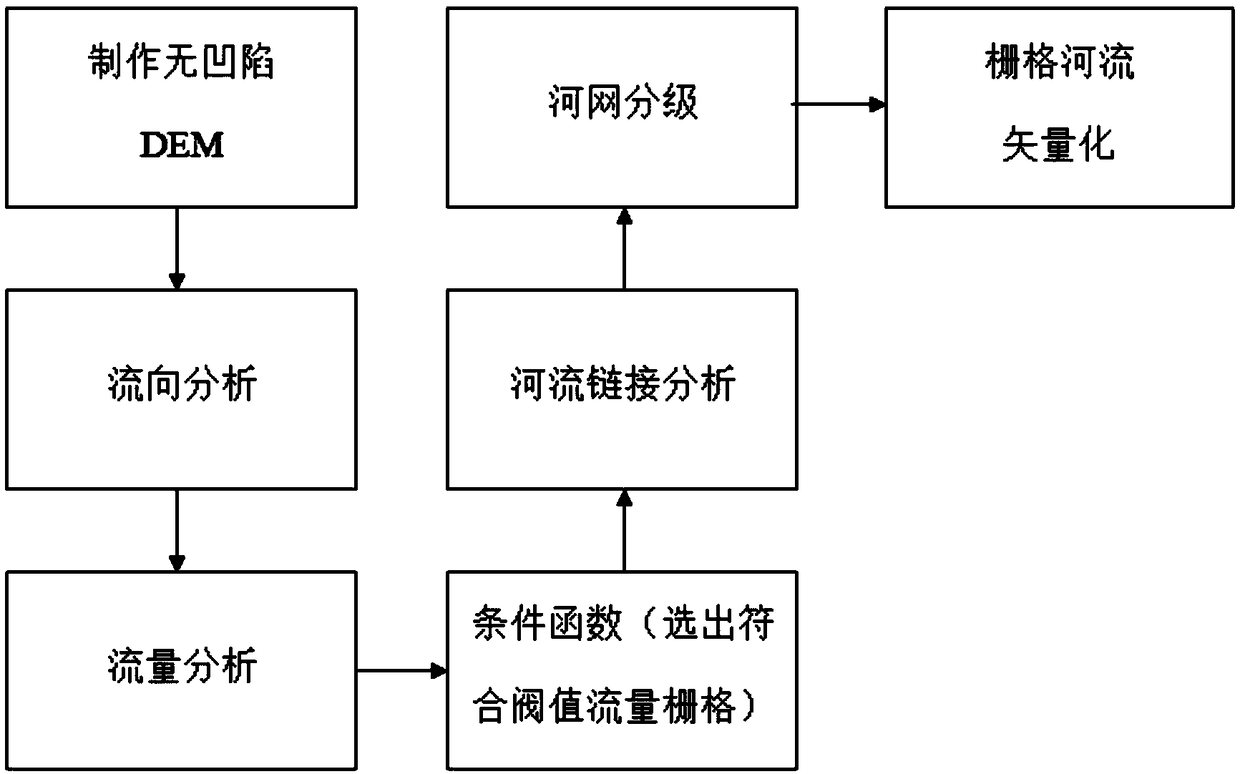
[0021] The purpose of the present invention is to provide a method for generating a GIS river network map. The key technology used in the GIS river network map is WebGIS technology to realize a GIS map. Combined with the global river information system, a high-precision river network map is generated based on the global river network data, river section data, and river boundary condition data provided by the basic geographic information.

[0022] A method for generating a GIS river network map, including a river network extraction method and a river network classification method. Among them, the river network extraction is to obtain the river channel through the method of hydrological simulation of surface confluence. River network classification is a method of assigning class numbers to connecting lines in a river network.

[0023] Wherein, the described river network extraction methods are divided into two categories: one is a geomorphological method based on contour lines ...


PUM


Abstract

A GIS-based river network map generation method comprises a river network extraction and river network classification method based on surface confluence, wherein, the river network extraction method comprises the DEM depression pretreatment, the raster flow direction judgment, the upstream catchment area accumulation, the river section identification, the vectorization of river course and boundaryelements, and the topographic parameter statistics. The river network classification method comprises a Strahler method and a Shreve method. The invention combines a global river information system and generates a high-precision river network map according to the global river network data, the river section data, the river boundary condition data and the like of the basic geographic information provided by the global river information system, thereby providing an intuitive and realistic decision environment for relevant personnel.

Description

technical field [0001] The invention relates to the field of computer application technology, in particular to a GIS-based river network diagram generation method. technical background [0002] There are many rivers distributed all over the world, stretching and meandering on the land, and finally flowing into the sea, like "the blood vessels of the earth", not only carrying the global hydrological cycle, but also driving the global water and air cycle, environmental changes, and ecological evolution process. The river network is the transport and dissipation channel of material and energy in the watershed, and it is the topological structure of the inflow and sink of many rivers in the watershed. The shape of the river network reveals the morphological characteristics and development stage of the river basin landform, and the statistical parameters of the river network are used as the index parameters of the river basin landform structure. The inherent law of this paramet...

Claims


Application Information

Patent Timeline
Patent Type & Authority Applications(China)
IPC IPC(8): G06F16/29
CPCY02A10/30
Inventor 黄睿军
Owner QINGHAI ZHONGSHUI DIGITAL INFORMATION TECH CO LTD
Why Eureka
Try Eureka