A method and apparatus for map data thinning

A map data and map technology, applied in the field of geospatial information, can solve the problems that it is difficult to meet the needs of continuous display of points, and does not consider the continuity of thinning display

Active Publication Date: 2018-12-14
HANGZHOU HIKVISION SYST TECH
View PDF3 Cites 14 Cited by
  • Summary
  • Abstract
  • Description
  • Claims
  • Application Information

AI Technical Summary

Problems solved by technology

Moreover, none of the above technologies consider the continuity of the thinning display. After thinning the map data, the results displayed at each map level are different. Assume that the thinning results of the 11th-level map include point A, and the thinning results of the 12th level It has nothing to do with the thinning results of level 11, and the points displayed after the thinning may not include the point A, which is difficult to meet the needs of continuous display of points in multiple map levels

Method used


Image

  • A method and apparatus for map data thinning
  • A method and apparatus for map data thinning
  • A method and apparatus for map data thinning

Examples


Embodiment Construction

[0084] In order to make the object, technical solution and advantages of the present invention clearer, the implementation manner of the present invention will be further described in detail below in conjunction with the accompanying drawings.

[0085] figure 1 It is a flowchart of a map data thinning method provided by an embodiment of the present invention. see figure 1 , the method includes:

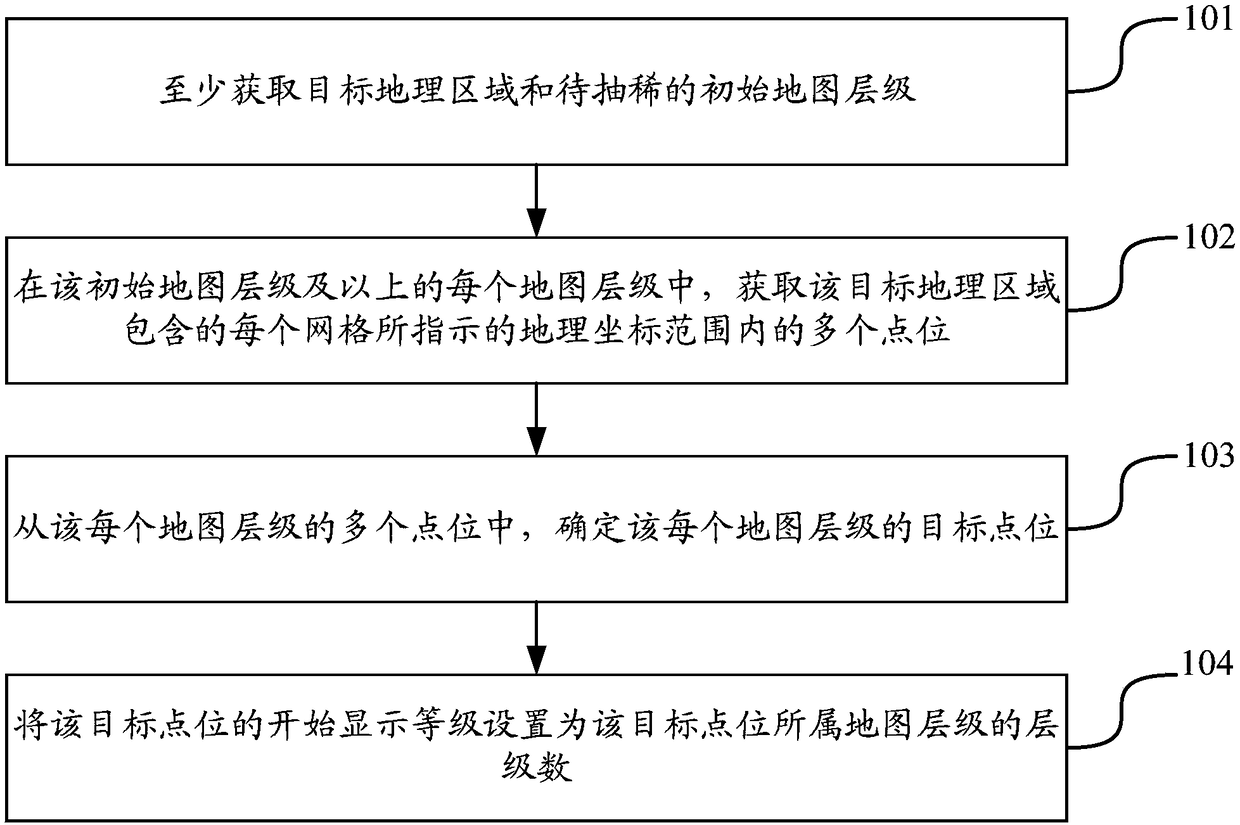
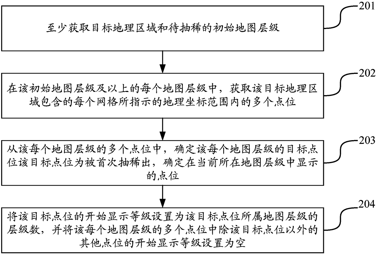
[0086] 101. Acquire at least a target geographic area and an initial map level to be thinned.

[0087] 102. At the initial map level and each map level above, acquire multiple points within the geographic coordinate range indicated by each grid included in the target geographic area.

[0088] 103. From the multiple points of each map level, determine the target point of each map level, the target point is extracted for the first time, and determine the point displayed in the current map level.

[0089] 104. Set the start display level of the target point to the level number of the...


PUM


Abstract

The invention discloses a map data thinning method and device, belonging to the field of geospatial information. The method comprises the following steps: acquiring at least a target geographic regionand an initial map hierarchy to be thinned; acquiring a plurality of point positions within a geographic coordinate range indicated by each grid included in a target geographic region in each map hierarchy of the initial map hierarchy and above; determining a target point position of each map hierarchy from the plurality of point positions of each map hierarchy; setting the start display level ofthe target point position to the hierarchy number of the map hierarchy to which the target point position belongs, wherein the start display level of the target point position is used to indicate that the target point position is displayed in a map hierarchy in which the hierarchy number is equal to or greater than the start display level. The invention can meet the requirement that the point positions are continuously displayed in a plurality of map hierarchies, and only the target point positions are displayed in each grid of each hierarchy, so that the purpose of thinning is achieved, andthe point positions on the map can be evenly distributed.

Description

[0001] This application claims the priority of the Chinese patent application with the application number 201710425305.0 and the invention title "map data thinning method and device" submitted to the China Patent Office on June 07, 2017, the entire contents of which are incorporated by reference in this application. technical field [0002] The invention relates to the field of geospatial information, in particular to a map data thinning method and device. Background technique [0003] With the development of geospatial information technology, maps are gradually becoming popular, which brings great convenience to people's travel and life. With the increasing amount of map data, a large number of map data (points) on the map may easily cause spatial overlap, which not only affects the appearance, but also increases the difficulty of data processing. Therefore, there is an urgent need for a map data thinning method to thin the map data so as to present a better map display eff...

Claims


Application Information

Patent Timeline
Patent Type & Authority Applications(China)
IPC IPC(8): G06F17/30G06T3/40
CPCG06T3/40
Inventor 蒋文平张乐天林圣拿胡靓瑾
Owner HANGZHOU HIKVISION SYST TECH
Why Eureka
Try Eureka