
Automatic planning land checking method, electronic device, storage medium and system

An automatic and planning technology, applied in data processing applications, electrical digital data processing, special data processing applications, etc., can solve the problems of low degree of automation and intelligence, and cannot fundamentally improve the operation mode and work efficiency of land planning verification , to achieve the effect of improving the accuracy

Active Publication Date: 2018-11-23
HUBEI UNIV
View PDF7 Cites 13 Cited by
  • Summary
  • Abstract
  • Description
  • Claims
  • Application Information

AI Technical Summary

Problems solved by technology

[0008] Based on at least one of the above-mentioned technical problems, the present invention proposes an automatic verification method, equipment, medium and system for planning land use, which solves the problem that the existing verification method for planning land use is low in automation and intelligence, and cannot fundamentally improve traditional land planning. Check the operation method and work efficiency

Method used


Image

  • Automatic planning land checking method, electronic device, storage medium and system
  • Automatic planning land checking method, electronic device, storage medium and system

Examples


Embodiment Construction

[0038] In order to make the object, technical solution and advantages of the present invention clearer, the present invention will be further described in detail below in conjunction with the accompanying drawings and embodiments. It should be understood that the specific embodiments described here are only used to explain the present invention, not to limit the present invention.

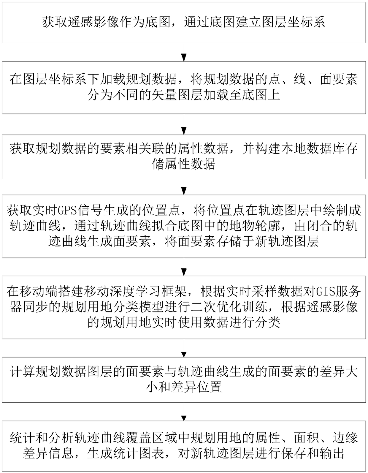
[0039] Automatic verification methods for planned land use, such as figure 1 shown, including the following steps:

[0040]Layer management, obtain the remote sensing image as the base map, and establish the layer coordinate system through the base map; preferably, the step layer management is specifically to synchronize the remote sensing image from the GIS server as the base map; in this embodiment, the mobile terminal realizes the required Centralized management of the layers of the map used. First, select the data source that needs to preload the base map, such as Baidu online image map, Goog...


PUM


Abstract

The invention provides an automatic planning land checking method. The automatic planning land checking method comprises the steps of: performing graphic layer management, obtaining a remote sensing image as the underlying graph, and establishing a graphic layer coordinate system through the underlying graph; performing planning data loading, loading planning data in the graphic layer coordinate system, separating point, line and surface elements of the planning data into different vector graphic layers, and loading to the underlying graph; performing track management, obtaining the position point generated by a real-time GPS signal, drawing a track curve in a track graphic layer according to the position point, fitting the terrain contour in the underlying graph through the track curve, generating the surface element from the closed track curve, and storing the surface element in a new track graphic layer; and performing automatic checking, and calculating the difference size and thedifference position of the surface element of the planning data graphic layer and the surface element generated by the track curve. By means of the automatic planning land checking method, the electronic device, the storage medium and the system provided by the invention, the planning land checking efficiency can be effectively increased; the checking cost can be reduced; and thus, effective technical support is provided for checking the planning land in our country.

Description

technical field [0001] The invention relates to the field of land resources management, in particular to an automatic verification method for planned land use, an electronic device, a storage medium and a system. Background technique [0002] Land use planning is divided into five levels: national, provincial, city, county, and township, corresponding to the administrative division level. my country has carried out the construction of the overall land use planning database, emphasizing the need to complete the database building, reporting and summary tasks on time and with quality assurance. How to realize further land use planning on the basis of the national land survey, improve the "one map" of land resources, realize the verification of land planning data, and ensure the accuracy of data is one of the important links. [0003] At present, most of the verification of planned land use in my country adopts the traditional manual operation mode. Under the background of the ...

Claims


Application Information

Patent Timeline
Patent Type & Authority Applications(China)
IPC IPC(8): G06F17/30G06K9/62G06Q50/26
CPCG06Q50/26G06F18/24
Inventor 金贵董寅李文强
Owner HUBEI UNIV
Learn More