A Crop Irrigation Guidance Method Based on Dual-polarization Synthetic Aperture Radar and Crop Model Assimilation

A technology of aperture radar and chemical synthesis, which is applied in the field of agricultural remote sensing, can solve problems such as difficult to realize high-precision estimation of irrigation amount, and achieve the effects of overcoming the influence of bad weather factors, increasing time resolution, and improving estimation accuracy

Active Publication Date: 2021-06-04
CHINA AGRI UNIV
View PDF0 Cites 0 Cited by
  • Summary
  • Abstract
  • Description
  • Claims
  • Application Information

AI Technical Summary

Problems solved by technology

Due to their inherent limitations, these methods are difficult to achieve high-precision estimation of the irrigation required for regional crops.

Method used


Image

  • A Crop Irrigation Guidance Method Based on Dual-polarization Synthetic Aperture Radar and Crop Model Assimilation
  • A Crop Irrigation Guidance Method Based on Dual-polarization Synthetic Aperture Radar and Crop Model Assimilation
  • A Crop Irrigation Guidance Method Based on Dual-polarization Synthetic Aperture Radar and Crop Model Assimilation

Examples


Embodiment 1

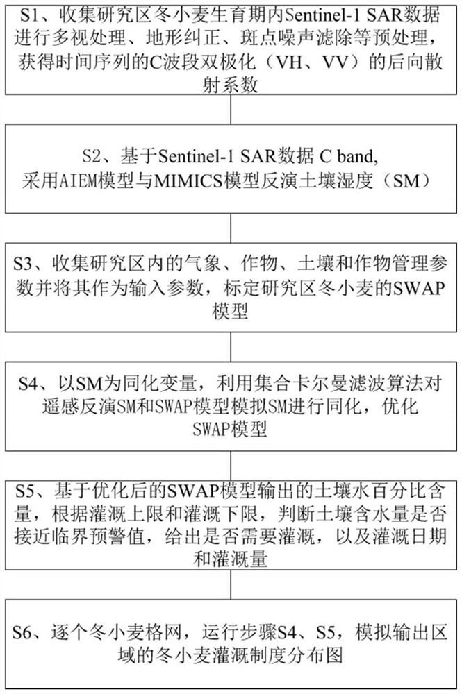
[0048] For the flow chart of winter wheat production estimation using the crop irrigation guidance method assimilated with the dual-polarization synthetic aperture radar and the crop model of the present invention, please refer to the attached figure 1 .

[0049] The three provinces of Hebei, Henan and Shandong were selected as the research area, which is located between 110°12′-122°42′ east longitude and 31°17′-42°41′ north latitude. The total area of ​​the study area is 509,000 square kilometers. The terrain is dominated by plains, and cultivated land accounts for more than 40% of the total area. It belongs to the warm temperate monsoon climate, with annual sunshine hours of 2300h and annual average precipitation of about 650mm.

[0050] S1. Collect the satellite data of the dual-polarization synthetic aperture radar during the growth period of the winter wheat to be measured in the research area, and perform preprocessing to obtain the VH and VV dual-polarization backscatte...


PUM


Abstract

The invention belongs to the field of agricultural remote sensing, and relates to a method for guiding crop irrigation by assimilating a dual-polarization synthetic aperture radar and a crop model. The specific steps are: collecting and preprocessing the satellite data of the dual-polarization synthetic aperture radar, and adopting an AIEM model and a MIMICS model Retrieve soil moisture SM; calibrate the SWAP model of crops in the study area; use the ensemble Kalman filter algorithm to assimilate the obtained remote sensing retrieval SM and the obtained SWAP model to simulate SM, and optimize the SWAP model; crop-by-crop grid based on the soil output from the optimized SWAP model The water percentage content can be used to obtain the irrigation demand, and the regional crop irrigation system mapping can be obtained to guide the crop production. The method of the present invention combines the advantages of SAR remote sensing data and crop models, using SAR remote sensing data to effectively overcome the lack of satellite remote sensing data under cloud and rain conditions, greatly increasing the time resolution of available data, and effectively improving the estimation of regional crop soil moisture precision.

Description

technical field [0001] The invention belongs to the field of agricultural remote sensing, and in particular relates to a crop irrigation guidance method for assimilating a dual-polarization synthetic aperture radar and a crop model. Background technique [0002] Traditional crop irrigation guidance methods mainly include statistical survey methods, crop model-based forecasting methods, and agrometeorological forecasting methods. Due to their inherent limitations, these methods are difficult to estimate the irrigation required by regional crops with high precision. The estimation method based on satellite remote sensing technology has unique advantages in estimating the irrigation required for regional crops by virtue of its spatial continuity and temporal dynamic characteristics. At the same time, the combination of remote sensing technology and crop growth models based on crop photosynthesis, respiration, transpiration, nutrition and other mechanism processes can achieve t...

Claims


Application Information

Patent Timeline
Patent Type & Authority Patents(China)
IPC IPC(8): G01S13/90G01N33/00
CPCG01N33/0098G01S13/90G01S13/9076
Inventor 黄健熙李俐卓文苏伟刘峻明刘哲张超朱德海张晓东
Owner CHINA AGRI UNIV
Why Eureka
Try Eureka