
Unmanned aerial vehicle path planning method for aerial photography and management system

A path planning and management system technology, applied in the control/regulation system, three-dimensional position/channel control, vehicle position/route/altitude control and other directions, can solve the problem of prolonging the waiting time of tourists, low UAV efficiency, reducing UAV efficiency issues

Pending Publication Date: 2018-11-06
GUANGZHOU EHANG INTELLIGENT TECH
View PDF6 Cites 18 Cited by
  • Summary
  • Abstract
  • Description
  • Claims
  • Application Information

AI Technical Summary

Problems solved by technology

[0003] In the existing scheme of using drones to take aerial photos of tourists, the drone management system does not group the targets of the scheduled aerial photography service, but directly dispatches drones to perform aerial photography tasks for one or several targets. The number of aerial photography targets for a single mission performed by the UAV is based on experience, which makes the efficiency of UAV aerial photography missions low and prolongs the waiting time for tourists; at the same time, the distribution between UAVs and mission targets is not reasonable, resulting in The cruising distance of UAVs in the process of performing aerial photography tasks is longer, which reduces the efficiency of UAVs in performing aerial photography tasks

Method used


Image

  • Unmanned aerial vehicle path planning method for aerial photography and management system
  • Unmanned aerial vehicle path planning method for aerial photography and management system
  • Unmanned aerial vehicle path planning method for aerial photography and management system

Examples


Embodiment Construction

[0077] In order to make the objectives, technical solutions and advantages of the present invention clearer, the technical solutions in the embodiments of the present invention will be described in more detail below in conjunction with the drawings in the embodiments of the present invention.

[0078] It should be noted that: in the drawings, the same or similar symbols represent the same or similar elements or elements with the same or similar functions. The described embodiments are part of the embodiments of the present invention, but not all of the embodiments. In the case of no conflict, the embodiments in the present application and the features in the embodiments can be combined with each other. Based on the embodiments of the present invention, all other embodiments obtained by persons of ordinary skill in the art without creative efforts fall within the protection scope of the present invention.

[0079] In this document, "first", "second" and so on are only used to d...


PUM


Abstract

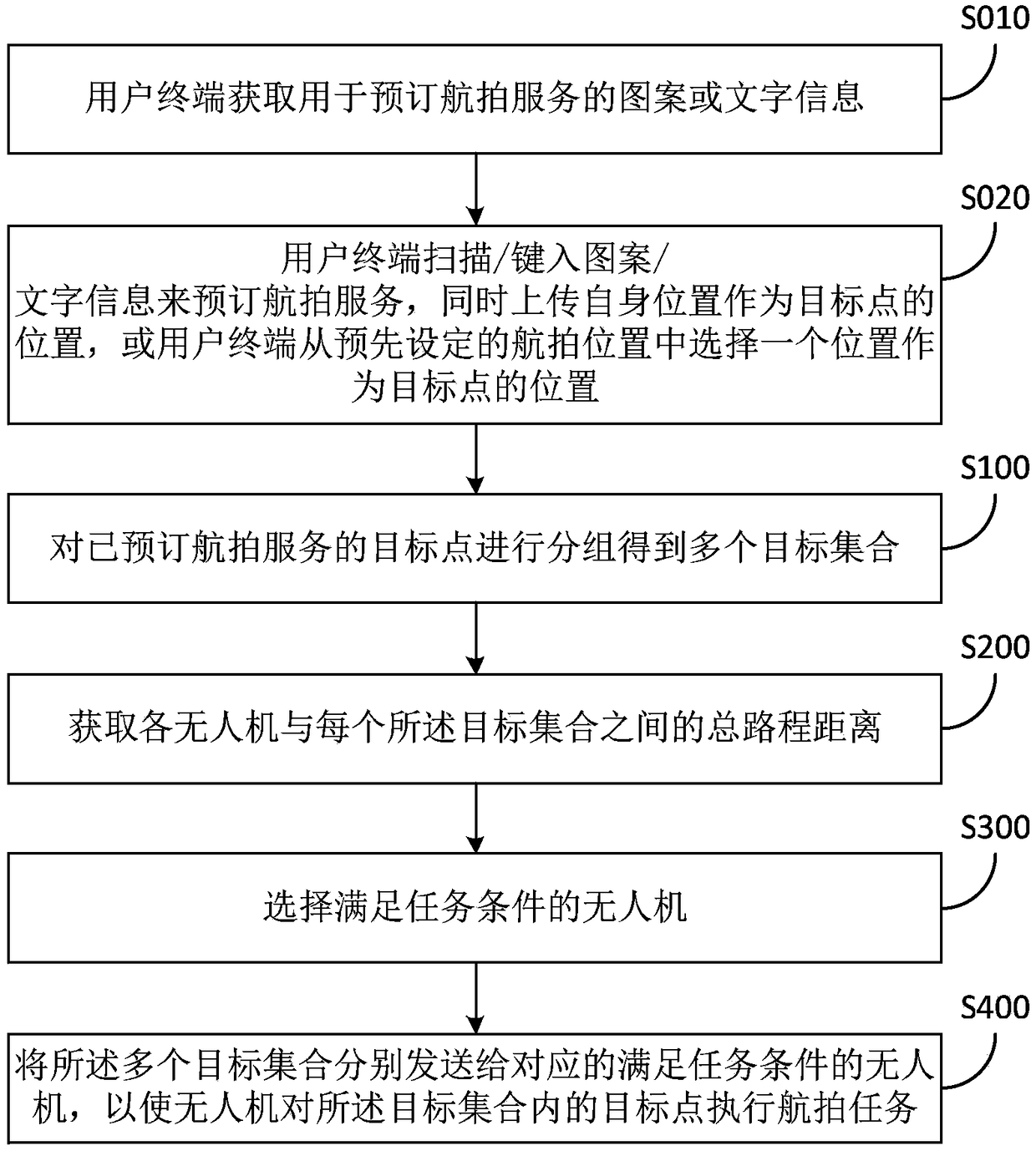
The invention relates to the technical field of unmanned aerial vehicles, and particularly provides an unmanned aerial vehicle path planning method for aerial photography and a management system. Themethod comprises steps: target points which book aerial photography service are firstly grouped to obtain multiple target sets; the total path distance between the unmanned aerial vehicle and each target set is then acquired; an unmanned aerial vehicle meeting task conditions is then selected, wherein the met task conditions comprise the remaining cruise distance of the unmanned aerial vehicle being longer than the total path distance between the unmanned aerial vehicle and the target set and the unmanned aerial vehicle having no fault; and finally, the multiple target sets are sent to corresponding unmanned aerial vehicles meeting the task conditions to enable the unmanned aerial vehicle to execute an aerial photography task on a target point in the target set. According to the unmanned aerial vehicle path planning method and the management system provided in the invention, before the unmanned aerial vehicle is sent to execute a task, the targets which book aerial photography serviceare firstly grouped, an unmanned aerial vehicle meeting conditions is then selected according to a grouping condition, the efficiency of executing the aerial photography task by the unmanned aerial vehicle is improved, and the waiting time of a tourist is shortened.

Description

technical field [0001] The invention relates to the technical field of unmanned aerial vehicles, in particular to an unmanned aerial vehicle path planning method and management system for aerial photography. Background technique [0002] As an emerging high-end technology product in recent years, drones have been widely used in many different fields, such as military reconnaissance drones, and drones used as climate data acquisition equipment in meteorological surveys. Among them, drones also have broad application prospects in tourism projects. For example, tourists can book drone aerial photography services at scenic spots or places of interest. After tourists book aerial photography services, drones will fly to The location of tourists, and according to the type of service booked by tourists, provide services such as continuous photo taking and regular video recording for tourists. Generally speaking, during the process of performing an aerial photography mission, the dr...

Claims


Application Information

Patent Timeline
Patent Type & Authority Applications(China)
IPC IPC(8): G05D1/10
CPCG05D1/101
Inventor 胡华智
Owner GUANGZHOU EHANG INTELLIGENT TECH
Learn More