
A Cooperative Positioning Method Based on Time of Arrival for Wireless Sensor Networks

A wireless sensor network, cooperative positioning technology, applied in positioning, network topology, wireless communication and other directions, can solve the problems of increasing convex optimization, difficulty and so on

Active Publication Date: 2020-08-18
NINGBO UNIV
View PDF2 Cites 0 Cited by
  • Summary
  • Abstract
  • Description
  • Claims
  • Application Information

AI Technical Summary

Problems solved by technology

However, solving the maximum likelihood estimation is a very difficult task, because the maximum likelihood estimation function is nonlinear and non-convex, and there is no closed-form solution, but when the number of available anchor nodes is limited or the unknown node is located at the anchor node When the convex hull is outside the convex hull, although the complexity of convex optimization is a bit increased, it can provide quite high accuracy

Method used


Image

  • A Cooperative Positioning Method Based on Time of Arrival for Wireless Sensor Networks
  • A Cooperative Positioning Method Based on Time of Arrival for Wireless Sensor Networks
  • A Cooperative Positioning Method Based on Time of Arrival for Wireless Sensor Networks

Examples


Embodiment Construction

[0019] The present invention will be further described in detail below in conjunction with the accompanying drawings and embodiments.

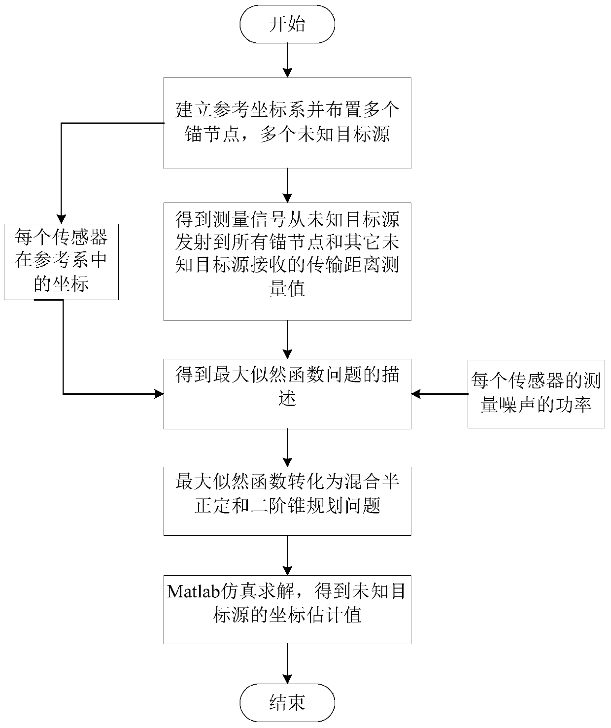
[0020] A time-of-arrival-based cooperative positioning method applied to wireless sensor networks proposed by the present invention, its overall realization block diagram is as follows figure 1 As shown, it includes the following steps:

[0021] Step 1: In the wireless sensor network environment, establish a planar rectangular coordinate system or a spatial coordinate system as the reference coordinate system, and set M anchor nodes and N unknown target sources; then set the M anchor nodes in the reference coordinate system The corresponding coordinates in the system are denoted as s 1 ,s 2 ,...,s M , record the coordinate correspondence of N unknown target sources in the reference coordinate system as x 1 ,x 2 ,...,x N ; Wherein, M≥2, M=4 in this embodiment, N≥2, N=5 in this embodiment, s 1 is the coordinate of the first anchor node in...


PUM


Abstract

The invention discloses an arrival time-based cooperative localization method applied to a wireless sensor network, which uses a second-order cone relaxation technique and a positive semi-definite relaxation technique to relax a minimization problem obtained by constructing a maximum likelihood function to obtain a description of the problem mixing positive half-definite and second-order cone programming; thus, a global optimal solution can be ensured to obtain without the influence of local convergence, and the localization accuracy is high; the influence of measurement noise error can be effectively suppressed; meanwhile, the prior art can be used for solving an estimate value of the coordinates of an unknown target source, thereby reducing the distribution density of the anchor nodes and reducing the cost.

Description

technical field [0001] The invention relates to a target positioning method, in particular to a time-of-arrival-based cooperative positioning method applied to a wireless sensor network. Background technique [0002] Wireless sensor network technology has been widely used in military, industrial and commercial activities, and determining the specific location of each sensor in wireless sensor network is one of the core problems to be solved by this technology. GPS positioning is only effective in outdoor environments. In special scenarios such as indoors, new positioning methods must be sought. The usual method is to first deploy nodes with known positions manually or by other means. These nodes with known positions are called anchor nodes (Anchor-Nodes), and nodes that do not know their positions in advance are located through anchor nodes. Nodes whose positions are unknown are called Unknown-Nodes, that is, unknown target sources, and usually use noisy measurements to det...

Claims


Application Information

Patent Timeline
Patent Type & Authority Patents(China)
IPC IPC(8): H04W64/00H04W84/18G01S5/06
CPCG01S5/06H04W64/006H04W84/18
Inventor 卢倩倩李有明常生明李娜娜
Owner NINGBO UNIV
Learn More