Method for evaluating spatial planning rationality of waterfront area

An evaluation method and a rational technology, applied in the field of urban landscape research, can solve problems such as lack of project settings, plagiarism and imitation, and lack of rational data support

Inactive Publication Date: 2018-10-12
CHINA UNIV OF GEOSCIENCES (WUHAN)
View PDF3 Cites 2 Cited by
  • Summary
  • Abstract
  • Description
  • Claims
  • Application Information

AI Technical Summary

Problems solved by technology

[0002] At present, the planning and design of urban waterfront areas mostly rely on the designer's personal visual aesthetic standards, and are accustomed to refer to so-called templates, lacking rational data support, resulting in a lack of objectivity, scientificity, or plagiarism and imitation in project settings.

Method used


Image

  • Method for evaluating spatial planning rationality of waterfront area
  • Method for evaluating spatial planning rationality of waterfront area
  • Method for evaluating spatial planning rationality of waterfront area

Examples


Embodiment Construction

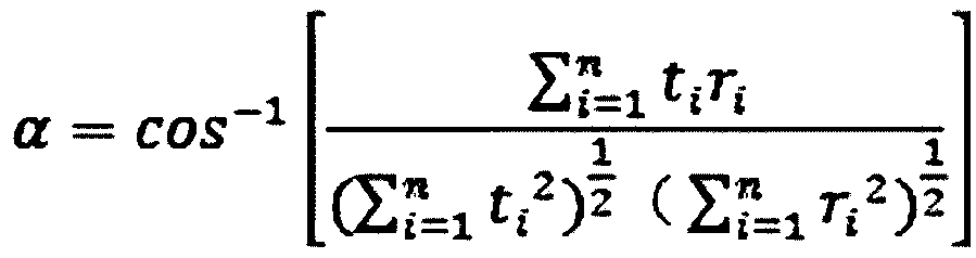
[0037] In order to make the purpose, technical solution and advantages of the present invention clearer, the embodiments of the present invention will be further described below in conjunction with the accompanying drawings.

[0038] Please refer to figure 1 , the embodiments of the present invention provide a method for evaluating the rationality of waterfront spatial planning, which is used to assist urban planning departments to scientifically formulate the development and construction of urban waterfronts. The method includes the following steps:

[0039] S1: Locate the waterfront on the city map.

[0040]Scientifically define the waterfront area. There are many ways to define the waterfront area. The commonly used ones are the water area space of 200-300m and the adjacent urban road area space. The word induced distance comes from the definition of the waterfront area, which can be understood as the radius of the waterfront area) is 1-2km, which is equivalent to the dist...


PUM


Abstract

The invention provides a method for evaluating spatial planning rationality of a waterfront area. The method is used for assisting a city planning department to scientifically make development and construction of the waterfront area of a city. The method comprises the following steps of S1: locating the waterfront area on a city map; 2: collecting information and data of the waterfront area; S3: establishing an evaluation system by utilizing the information and the data of the waterfront area to evaluate characteristics, reachability and artistic conception of the waterfront area; and S4: performing overlay analysis on the characteristics, reachability and artistic conception of the waterfront area to obtain a spatial planning rationality evaluation result of the waterfront area. The method has the beneficial effects that the city planning department can be assisted to scientifically make spatial development construction and improvement schemes of a city waterfront and scientifically and rationally evaluate a current spatial distribution situation of the waterfront area so as to make a spatial regulation and control policy of the waterfront area of the city clear.

Description

technical field [0001] The invention relates to the field of urban landscape research, in particular to a method for evaluating the rationality of spatial planning of a waterfront area. Background technique [0002] At present, the planning and design of urban waterfront areas mostly rely on the designer's personal visual aesthetic standards, and are accustomed to refer to so-called templates, lacking rational data support, resulting in a lack of objectivity, scientificity, or plagiarism and imitation in project settings. Contents of the invention [0003] In view of this, the embodiment of the present invention provides a method for evaluating the rationality of waterfront space planning, which is used to assist urban planning departments to scientifically formulate urban waterfront space development, construction and improvement plans, and scientifically and rationally evaluate waterfront space. Distribution status, in order to clarify the spatial regulation strategy of ...

Claims


Application Information

Patent Timeline
IPC IPC(8): G06Q10/06G06Q10/04G06Q50/26
CPCG06Q10/043G06Q10/06393G06Q50/26
Inventor 刘璇冰河代棋帆于丽
Owner CHINA UNIV OF GEOSCIENCES (WUHAN)
Why Eureka
Try Eureka