
pdf tile map and its production method

A technology of tile map and production method, which is applied in the field of PDF maps, can solve the problem that the effect of symbolic maps is not as good as that of other problems, and achieve the effects of improving user experience, high-quality map visualization services, and enriching user experience

Active Publication Date: 2021-05-18
中国人民解放军61540部队
View PDF5 Cites 2 Cited by
  • Summary
  • Abstract
  • Description
  • Claims
  • Application Information

AI Technical Summary

Problems solved by technology

Usually, the vector tile map uses graphical representation, based on geographic elements, and quickly obtains a symbolic map by establishing a symbolic mapping mechanism, but the effect of this symbolic map is far inferior to the standard map for publication after editing

Method used


Image

  • pdf tile map and its production method
  • pdf tile map and its production method
  • pdf tile map and its production method

Examples


Embodiment Construction

[0092] The present invention will be described in detail below in combination with specific embodiments.

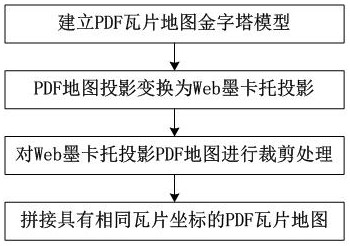
[0093] The present invention relates to a PDF tile map and a production method thereof. The strategy of storing the PDF map in blocks in the PDF format is adopted to establish a PDF tile map pyramid model, and transform other projected PDF maps into a Web Mercator projection PDF map through projection. Based on the PDF tile map pyramid model, the Web Mercator projection PDF map is cropped, and the PDF tile maps with the same tile coordinates are stitched together to finally obtain the PDF tile map, such as figure 1 shown, including the following steps:

[0094] Step 1: Create a pyramid model of the PDF tile map.

[0095] The pyramid model is a multi-scale model. While maintaining data continuity, it can use the magnification relationship to build the model, and realize functions such as infinite zooming and seamless roaming of PDF tile maps. In the whole process of buil...


PUM


Abstract

The invention relates to a PDF tile map and a production method thereof. The PDF tile map adopts the tile pyramid model to store graphical information with map expression and interactive geographic information in PDF format, and has all the features of the PDF map. The production method mainly includes: first establish the PDF tile map pyramid model, and then project the other The PDF map of the project is transformed into a Web Mercator projection PDF map through projection transformation, and finally the Web Mercator projection PDF map is clipped based on the PDF tile map pyramid model, and the PDF tile maps with the same tile coordinates are spliced. Finally get a PDF tile map. The PDF tile map in the present invention can not only provide multi-level grid tile map services, but also has the ability to interact with geographic elements. Through tile processing, the PDF map can be seamlessly organized and managed and various map visualization services can be provided to make the PDF map The use of is no longer limited by the map frame.

Description

technical field [0001] The invention belongs to the technical field of PDF maps, and in particular relates to a PDF tile map and a production method thereof. Background technique [0002] PDF (portable document format) is a widely used electronic document format developed and designed by Adobe. Its notable feature is that it can maintain the same display effect on different devices. GeoPDF is a registered trademark of TerraGo Technologies, a subsidiary of Layton Graphics, and is rapidly becoming the first format for map distribution. The OGC organization has adopted GeoPDF as a recommended map coding standard. At present, the use of GeoPDF is based on a single image, and users can only be limited to one GeoPDF file when browsing GeoPDF, which is a big defect when using GeoPDF. PDF map is an important result of domestic research on Geospatial PDF, and its production and use are similar to GeoPDF. [0003] The map "tile" technology is the main way to solve the Internet map s...

Claims


Application Information

Patent Timeline
Patent Type & Authority Patents(China)
IPC IPC(8): G06F16/29
Inventor 周校东黄利民何列松谢鹏
Owner 中国人民解放军61540部队
Learn More