A positioning and attitude measurement method for online real-time estimation and compensation of magnetometer errors

A magnetometer, real-time computing technology, applied in satellite radio beacon positioning system, radio wave measurement system, measurement device, etc.

Active Publication Date: 2020-05-08
NO 54 INST OF CHINA ELECTRONICS SCI & TECH GRP
View PDF13 Cites 0 Cited by
  • Summary
  • Abstract
  • Description
  • Claims
  • Application Information

AI Technical Summary

Problems solved by technology

[0006] The premise of using the magnetometer to obtain the heading is that the geomagnetic field where the magnetometer is located is free from external interference, but in the actual vehicle navigation application, the magnetometer will be affected by the interference magnetic field generated by the metal structure of the vehicle, usually In other words, the direction of the interference magnetic field generated by the vehicle structure is fixed relative to the direction of the vehicle body. In the actual vehicle navigation application, since the MEMS INS is fixedly connected to the vehicle body, the interference magnetic field is in the MEMS INS coordinate system The projection of is also fixed, making it possible to eliminate the disturbing magnetic field

Method used


Image

  • A positioning and attitude measurement method for online real-time estimation and compensation of magnetometer errors
  • A positioning and attitude measurement method for online real-time estimation and compensation of magnetometer errors
  • A positioning and attitude measurement method for online real-time estimation and compensation of magnetometer errors

Examples


Embodiment Construction

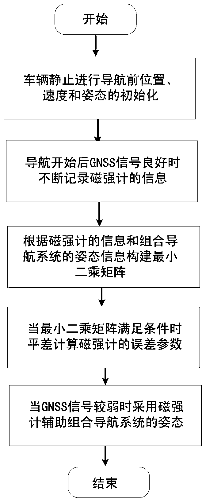
[0046] Below in conjunction with specific embodiment and accompanying drawing, the present invention will be further described:

[0047] Step 1: Perform initial alignment before vehicle navigation. In vehicle navigation applications, the integrated navigation receiver is fixedly connected to the vehicle body, and the GNSS / MINS integrated navigation receiver is initially aligned before navigation. The attitude information can be calculated by the accelerometer, and the heading information can be obtained by the magnetometer or dual antennas. If the heading information is initially aligned with the magnetometer-assisted MINS attitude, the magnetometer needs to be calibrated before alignment to eliminate the influence of the interfering magnetic field.

[0048] The specific process of initial alignment is as follows:

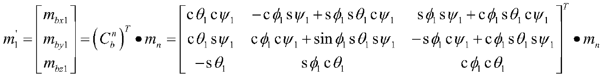
[0049] 1. The vehicle is in a static state before the navigation starts, power on the GNSS / MINS integrated navigation receiver, and continuously record the outpu...


PUM


Abstract

The invention discloses a positioning and posture measurement method for online estimating and compensating an error of a magnetometer in real time, which solves the problem in a GNSS / MINS combined navigation system that the MINS course information is rapidly scattered. The magnetometer and external interference magnetic intensity are calibrated in real time by utilizing the posture information provided by the combined navigation system when the GNSS observation state is good, the magnetometer information is used for assisting the INS to perform the navigation when the GNSS signal is interrupted, thereby improving the navigation precision of the system.

Description

technical field [0001] The present invention relates to the problem of positioning and attitude measurement of a GNSS / MINS (Global Navigation Satellite System / Micro InertialNavigation System) integrated navigation system, especially relates to using the attitude information calculated by the GNSS / MINS integrated navigation system as a reference to calibrate the error of the magnetometer so as to A method for improving the positioning and attitude measurement accuracy of the GNSS / MINS integrated navigation system when the GNSS signal is interrupted. Background technique [0002] GNSS has the advantages of global, fast, and all-weather positioning. It is the most widely used positioning method in the current positioning field. Its application fields cover various fields such as navigation, aerospace, and vehicle navigation. The GNSS signal is seriously blocked and causes a lot of signal multipath interference. In addition, the existence of various communication facilities in ...

Claims


Application Information

Patent Timeline
Patent Type & Authority Patents(China)
IPC IPC(8): G01C25/00G01C21/16G01C21/08G01S19/48G01S19/49
CPCG01C21/005G01C21/08G01C21/165G01C25/00G01S19/48G01S19/49
Inventor 蔚保国王青江智奇楠刘鹏飞马国驹贾瑞才
Owner NO 54 INST OF CHINA ELECTRONICS SCI & TECH GRP
Why Eureka
Try Eureka