
Satellite remote sensing-based sea surface drift and oil spill drift and diffusion forecasting method

A technology of satellite remote sensing and satellite remote sensing data, which is applied in the field of sea surface drift and oil spill drift and diffusion prediction based on satellite remote sensing, which can solve the problem of low forecast efficiency and high efficiency in forecasting sea surface drift and oil spill drift paths, as well as their diffusion and delays. timing etc.

Active Publication Date: 2018-04-20
SICHUANG TECH CO LTD
View PDF5 Cites 14 Cited by
  • Summary
  • Abstract
  • Description
  • Claims
  • Application Information

AI Technical Summary

Problems solved by technology

[0003] Since the rapid forecasting technology for sea surface drift and oil spill drift and dispersion involves efficient integration of dynamic calculations related to the physical ocean environment, fully automatic data download and real-time graphic visualization system, the current prediction of sea surface drift and oil spill drift and spread Most of the related technologies are based on empirical judgment and observation and tracking, which have high cost and low forecasting efficiency, and because there is no coupled ocean dynamics model, it is impossible to accurately, quickly and efficiently forecast sea surface drifting objects and The drift path and spread of oil spills greatly affect the speed and accuracy of command and coordination work, which often delays the timing of emergency response to maritime emergencies

Method used


Image

  • Satellite remote sensing-based sea surface drift and oil spill drift and diffusion forecasting method
  • Satellite remote sensing-based sea surface drift and oil spill drift and diffusion forecasting method
  • Satellite remote sensing-based sea surface drift and oil spill drift and diffusion forecasting method

Examples


Embodiment Construction

[0044] The present invention will be described in detail below in conjunction with the accompanying drawings and specific embodiments. This embodiment is carried out on the premise of the technical solution of the present invention, and detailed implementation and specific operation process are given, but the protection scope of the present invention is not limited to the following embodiments.

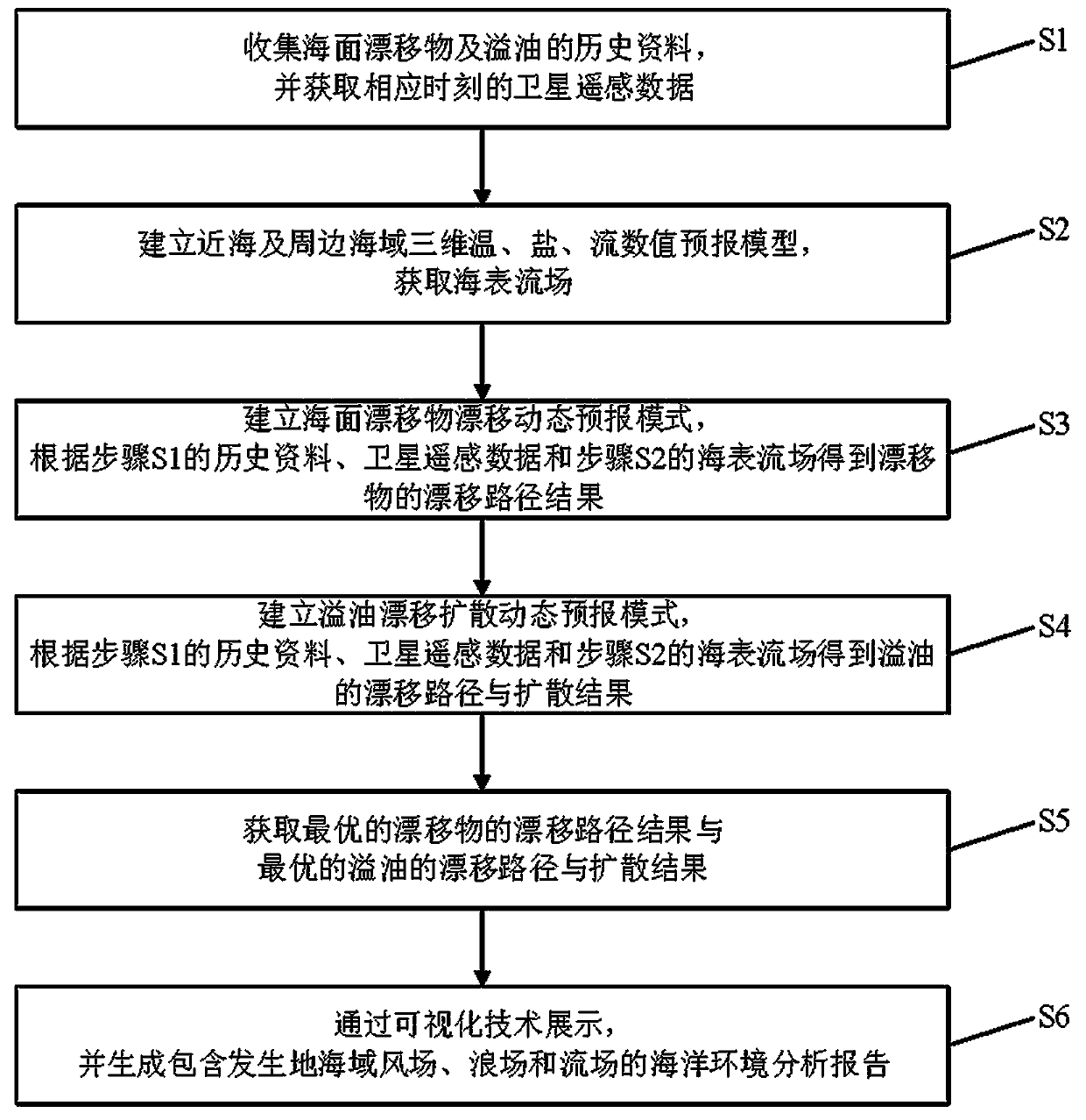
[0045] Such as figure 1 and figure 2 As shown, the method for forecasting drift and diffusion of sea surface drift and oil spill based on satellite remote sensing includes the following steps:

[0046] S1: Data collection

[0047] Collect data on marine accidents, missing persons, and marine oil spills in the past ten years, and obtain satellite remote sensing data at the corresponding time, establish a database of sea surface drift and oil spill drift and diffusion forecasting platform, and conduct case analysis.

[0048] S2: Establish a high-precision three-dimensional temperatu...


PUM


Abstract

The invention relates to a satellite remote sensing-based sea surface drift and oil spill drift and diffusion forecasting method. The method comprises the steps of S1, collecting data; S2, building three-dimensional temperature, salinity and current numerical forecasting models, and obtaining a sea surface current field; S3, establishing a drift dynamic forecasting mode of sea surface drifts, andobtaining drift path results of the drifts; S4, establishing an oil spill drift and diffusion dynamic forecasting mode, and obtaining drift paths and diffusion results of oil spillage; and S5, obtaining drift path results of drifts of different forecasting institutions, and in combination with the drift path results of the drifts obtained in the step 3, obtaining the optimal drift path result of the drifts; and meanwhile, obtaining the drift path results of the drifts of the different forecasting institutions, and in combination with the drift paths and the diffusion results of oil spill obtained in the step 4, obtaining the optimal drift path and diffusion result of oil spill. Compared with the prior art, the method overcomes the limitation of a forecasting institution; and multiple driftand diffusion forecasting results are integrated, so that the forecasting precision is improved.

Description

technical field [0001] The invention relates to the technical field of maritime search and rescue and the technical field of oil spill drift and diffusion prediction, in particular to a method for forecasting sea surface drift and oil spill drift and diffusion based on satellite remote sensing. Background technique [0002] With the expansion of the scale of ocean development and the rapid development of my country's offshore oil industry and offshore oil transportation industry, the scale of offshore oil exploration, development, and submarine pipeline laying continues to expand, frequent maritime activities, people falling into the water, ships, and various marine oil spills Sudden accidents at sea occur from time to time, and marine accidents are more concerned by people. Maritime accidents will bring huge disasters to the coastal countries of the world politically, economically and militarily. They will not only cause casualties and property losses, but also bring adverse...

Claims


Application Information

Patent Timeline
IPC IPC(8): G06Q10/04G06Q50/02G06Q50/26G06F17/30
CPCG06F16/29G06Q10/04G06Q50/02G06Q50/26
Inventor 蔡建统陈庆勇汤礼清单森华汤成锋
Owner SICHUANG TECH CO LTD
Learn More