Initial coarse alignment method used for navigation of unmanned underwater vehicles at polar regions
An unmanned aerial vehicle, initial alignment technology, applied in the direction of instruments, measuring devices, etc., can solve problems such as inapplicability, and achieve the effect of improving the initial coarse alignment accuracy
- Summary
- Abstract
- Description
- Claims
- Application Information
AI Technical Summary
Problems solved by technology
Method used
Image
Examples
Embodiment Construction
[0024] The present invention is described in further detail below in conjunction with specific embodiment:
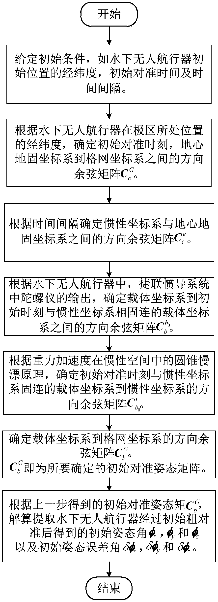
[0025] The main purpose of the present invention is to combine the characteristics of underwater unmanned vehicle navigation, and the characteristics of the natural environment and navigation environment of the polar region to design an initial coarse alignment method suitable for underwater unmanned vehicle navigation in the polar region.
[0026] In order to achieve the above object, the technical solution of the present invention mainly includes the following steps:
[0027] (1) According to the longitude and latitude of the position of the underwater unmanned vehicle in the polar region, determine the initial alignment time, and the direction cosine matrix between the earth-centered ground-fixed coordinate system e and the grid coordinate system G
[0028]
[0029] in, is the direction cosine matrix between the earth-centered earth-fixed coordinate system and...
PUM
 Abstract
Description
Claims
Application Information
 - R&D
- Intellectual Property
- Life Sciences
- Materials
- Tech Scout
- Unparalleled Data Quality
- Higher Quality Content
- 60% Fewer Hallucinations
Browse by: Latest US Patents, China's latest patents, Technical Efficacy Thesaurus, Application Domain, Technology Topic, Popular Technical Reports.
© 2025 PatSnap. All rights reserved.Legal|Privacy policy|Modern Slavery Act Transparency Statement|Sitemap|About US| Contact US: help@patsnap.com


