Geographical stripe SAR variable interval pulse sequence design method

A technology of sequence design and interval pulse, which is applied in computing, electrical digital data processing, special data processing applications, etc., can solve problems such as incomplete echo reception, achieve simplification of imaging processing, reduce data rate, and save storage space and the effect of the amount of data transferred

Active Publication Date: 2017-10-20
BEIHANG UNIV
View PDF7 Cites 0 Cited by
  • Summary
  • Abstract
  • Description
  • Claims
  • Application Information

AI Technical Summary

Problems solved by technology

[0004] The purpose of the present invention is to provide a solution to the problem of incomplete reception of echoes at some slant distances in the strip caused by pulse occlusion in the spaceborne geographic reference strip SAR

Method used


Image

  • Geographical stripe SAR variable interval pulse sequence design method
  • Geographical stripe SAR variable interval pulse sequence design method
  • Geographical stripe SAR variable interval pulse sequence design method

Examples


Embodiment

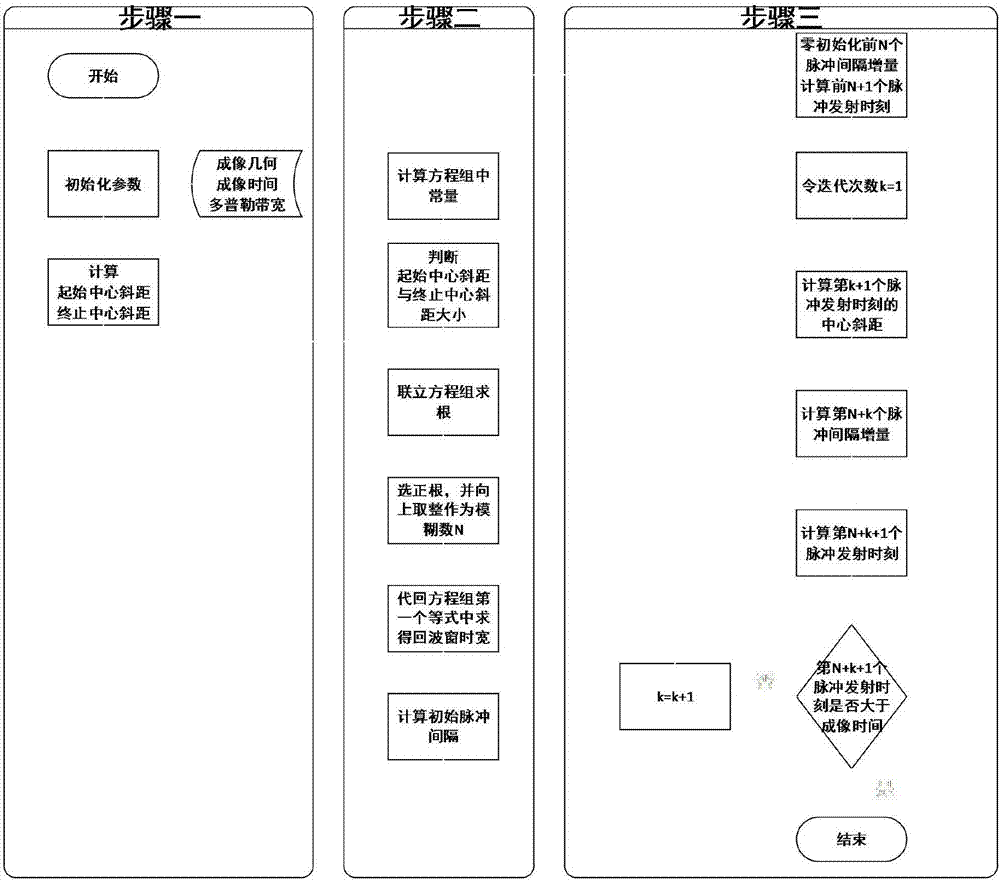
[0107] The present invention is a kind of geographic strip SAR pulse sequence design method with variable interval, the specific embodiment is:

[0108] Step 1: Given the imaging geometry of the platform and the target strip, calculate the initial center slant distance and the end center slant distance. Specifically:

[0109] 1. Parameter initialization

[0110] (1) The simulation parameters are given as shown in Table 1.

[0111] platform height m

500e3

Speed ​​m / s

7e3

Angle between strip and track°

45

Imaging time s

52.2115

Doppler bandwidth Hz

1400

Pulse width us

25

Protection time us

5

[0112] (2) Calculate the platform position vector at time 0 and aiming point position vector

[0113]

[0114]

[0115] (3) Calculate the platform position vector at the moment of imaging termination and aiming point position vector

[0116]

[0117]

[0118] (4) Calculate the initial center ...


PUM


Abstract

The invention discloses a geographical stripe SAR variable interval pulse sequence design method, which comprises the following steps: 1) providing imaging geometry of a platform and a target stripe, and calculating an initial center slope distance and a final center slope distance; 2) providing azimuth Doppler bandwidth and carrying out calculation to enable echo window time to be longest and meet initial pulse interval of whole-process non-aliasing sampling; and 3) substituting the initial pulse interval and the center slope distance course, calculating emission time of each pulse according to a recursion formula and obtaining all pulse sequences. The method can prevent the problem of pulse sheltering under the premise of enough sampling rate, and can carry out continuous imaging on stripes not parallel to platform trajectory and prevents transmission pulse shielding.

Description

technical field [0001] The invention relates to the field of synthetic aperture radar system design, in particular to a method for designing geographic strip SAR variable-interval pulse sequences. Background technique [0002] Synthetic aperture radar is an all-weather and all-weather earth observation method that is not affected by climate. It can obtain high-resolution images of large-scale ground areas, which effectively makes up for the shortcomings of optical imaging methods that are affected by time and weather. It is the main contemporary One of the space information remote sensing technologies. Traditional strip SAR is mainly used to image the target strip parallel to the radar track, while for the target area not parallel to the track, image stitching after multi-track multiple imaging is required, or a single wide imaging. These methods will prolong the data collection period or reduce the azimuth resolution, and at the same time have to receive and store useless ...

Claims


Application Information

Patent Timeline
IPC IPC(8): G01S13/90G06F17/50
CPCG01S13/90G06F30/00G01S13/9054
Inventor 李景文李春升姜予名王岩陈杰
Owner BEIHANG UNIV
Why Eureka
Try Eureka