
Automatic coordination method for space planning land difference

A technology of spatial planning and coordination methods, which is applied in the fields of geographic information and automatic coordination of land use differences in spatial planning. It can solve problems such as difficulty in improving efficiency, inability to coordinate differences, and different processing methods, so as to improve efficiency and accuracy, facilitate storage and Reading, reducing the effect of randomness

Active Publication Date: 2017-09-08
南京市城市规划编制研究中心
View PDF6 Cites 9 Cited by
  • Summary
  • Abstract
  • Description
  • Claims
  • Application Information

AI Technical Summary

Problems solved by technology

[0003] Among the existing methods or systems, in terms of automatic difference comparison, there are only methods for bill of materials, DWG format drawings, etc., and in terms of automatic difference processing, there are only methods for software data resources, server structures, etc.
However, the map used for spatial planning needs to be expressed simultaneously from two aspects, such as spatial location and land use properties. The differences in the content of the two drawings cannot be compared in terms of spatial positions, nor can subsequent difference coordination be carried out, so it is not applicable
[0004] The spatial analysis capability of GIS largely provides strong support for the automatic coordination of differences in spatial planning maps, but there are still some defects, mainly as follows: due to the variety and complexity of the actual situation, there are many types of spatial planning differences, and the processing methods are different. The same; moreover, in a city, the number of land plots with differences is often as high as hundreds of thousands. Even with the support of GIS spatial analysis capabilities, planners still need to do a lot of interpretation work for different situations. On the one hand, the workload Huge, difficult to improve efficiency; on the other hand, since the interpretation process is an empirical operation, misjudgments or inconsistent interpretations are unavoidable

Method used


Image

  • Automatic coordination method for space planning land difference
  • Automatic coordination method for space planning land difference
  • Automatic coordination method for space planning land difference

Examples


Embodiment Construction

[0025] This embodiment coordinates the difference between the two specific spatial plans (hereinafter referred to as "two plans") of the overall land use plan of the land department (hereinafter referred to as "land plan") and the urban planning department's overall urban plan (hereinafter referred to as "city plan") As an example, the specific implementation manner of the method of the present invention will be described with reference to the accompanying drawings.

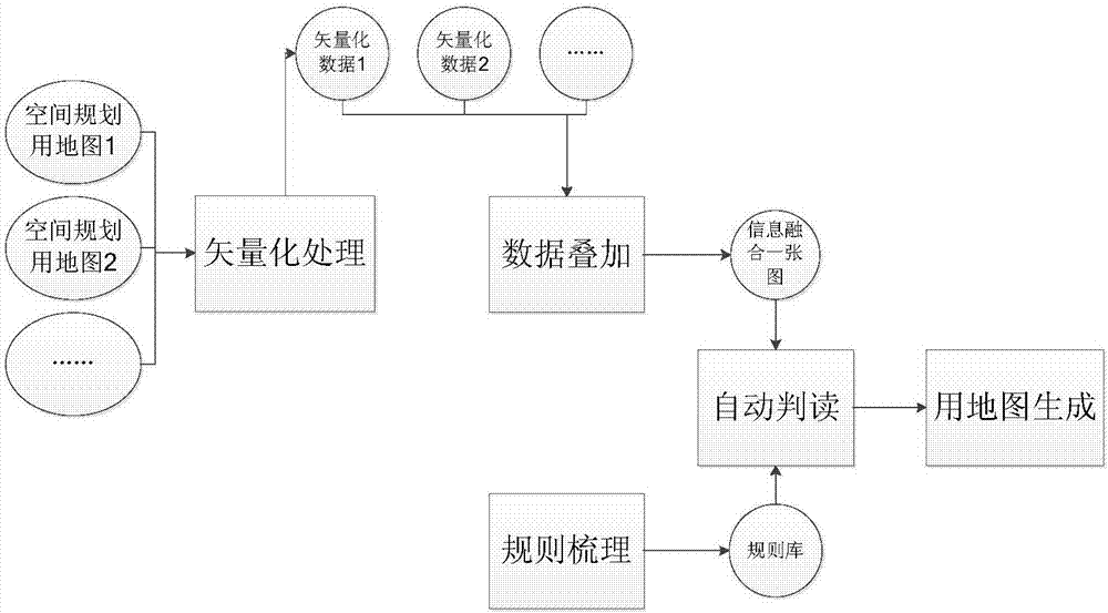
[0026] The automatic coordination method for spatial planning land use difference of the present invention includes five steps of vectorization processing, data superposition, establishment of spatial planning land use difference rule base, automatic interpretation and map generation, and the specific implementation process is as follows figure 1 Shown:

[0027] (1) Vectorization processing

[0028] Carry out vectorization processing on the construction land control area map in the land plan and the planning map...


PUM


Abstract

The invention discloses an automatic coordination method for space planning land difference. The method comprises the following steps of performing vectorization processing on a space planning land graph, dividing a whole city into different lands in the space, wherein each land is correlated with attributes such as land property; overlapping two or more space planning graphs after vectorization, thereby forming a graph with fused information; furthermore, forming a difference determining rule and a difference coordination rule according to a fixed format for difference determining methods and difference coordination methods between different space planning graphs; according to the difference determining rule and the difference coordination rule, determining each land in the graph with fused information, determining the attributes such as difference type, difference code and land property, and correlating the attributes with the land; and finally, according to the land property, forming a city space planning land graph in which the difference is eliminated. The automatic coordination method can improve efficiency of space planning difference coordination and ensures high coordination accuracy.

Description

technical field [0001] The invention relates to a method for automatically coordinating land use differences in spatial planning, which belongs to the field of geographic information technology. Background technique [0002] In recent years, "multi-plan integration" has become a hot topic. A key link of "multi-plan integration" is to coordinate the differences in land use between the land, planning, environmental protection, development and reform departments, and to achieve the coordination and consistency of space planning in land use. At present, the main method for coordinating land use differences in spatial planning is: based on GIS technology, the spatial superposition and comparison of various spatial plannings are carried out, and the planners interpret each land parcel with differences based on their own experience, and give The corresponding coordination opinions finally form a blueprint that eliminates differences and unifies various spatial plans. [0003] Amo...

Claims


Application Information

Patent Timeline
IPC IPC(8): G06Q10/06
CPCG06Q10/0631
Inventor 王芙蓉郑晓华吴掠桅崔蓓沈洁黄宇毛燕翎孙玉婷林小虎林洋王之永
Owner 南京市城市规划编制研究中心
Learn More