Construction method of large-scale remote sensing image feature point library

A remote sensing image and construction method technology, applied in the field of image processing, can solve problems such as time-consuming, labor-intensive, impossibility, and difficulty in obtaining ground control points, so as to improve processing efficiency and avoid repeated extraction

Active Publication Date: 2017-09-05
SOUTHEAST UNIV
View PDF4 Cites 1 Cited by
  • Summary
  • Abstract
  • Description
  • Claims
  • Application Information

AI Technical Summary

Problems solved by technology

[0003] The current UAV remote sensing image stitching detection technology generally requires air flight, ground control and indoor formation. Figure three Only one step can be applied to the management of land and resources. The ground deployment and control requires a large number of professionals to use professional measuring instruments to measure on the spot. In areas where the ground features are not obvious such as mountains, rivers, and forests, personnel cannot reach or accurately locate the ground control points. It is often difficult or impossible to obtain, time-consuming and labor-intensive with little effect

Method used


Image

  • Construction method of large-scale remote sensing image feature point library
  • Construction method of large-scale remote sensing image feature point library
  • Construction method of large-scale remote sensing image feature point library

Examples


Embodiment Construction

[0026] The present invention will be further described below in conjunction with the accompanying drawings.

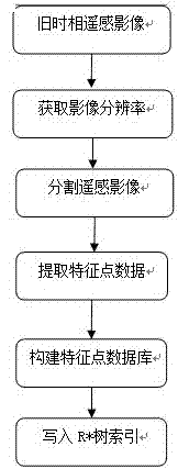
[0027] Such as figure 1 As shown, a method for constructing a large-scale remote sensing image feature point library includes the following steps:

[0028] Step 1. Obtain the resolution of the old phase remote sensing images through the open source class library GDAL. GDAL (Geospatial Data Abstraction Library) is an open source raster spatial data conversion library under the X / MIT license agreement. Among them, old-time phase remote sensing images such as survey area maps, satellite image maps, and drone image maps archived in the Land Bureau are related to old-time phase images.

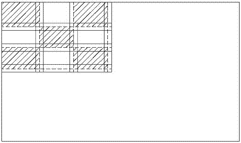
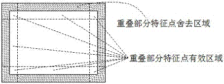
[0029] Step 2. Based on the resolution of the remote sensing image, the feature point detection algorithm is used to extract the feature point data as a criterion, and the size and number of tiles divided by the old phase remote sensing image are determined, so as to realize the overlapp...


PUM


Abstract

The invention provides a construction method of a large-scale remote sensing image feature point library. The method comprises the steps of determining dimensions of tiles, performing overlapping grid partition on a remote sensing image according to resolution information of the remote sensing image to achieve division of the remote sensing image, extracting feature points and descriptor data of the tiles by detection algorithms of the feature points of SIFT / SURF (scale invariant feature transform / speed up robust feature) and the like, and storing coordinate information corresponding to the feature points and descriptors in a spatial database by taking an R* tree as an index. The feature point spatial database generated by the method can be used for quick splicing templates or quick discovery and detection of variations of the remote sensing image; and compared with the prior art, the method takes feature point detection as pretreatment, avoids repeated detection and can improve processing efficiency.

Description

technical field [0001] The invention relates to the field of image processing, in particular to a technology for quickly splicing remote sensing images or using drone images to quickly discover changing land use in land surveys. Background technique [0002] In recent years, UAV remote sensing has shown broad application prospects in the field of land monitoring and surveillance with the advantages of low cost, flexible maneuverability, and rapid response. At present, using low-altitude remote sensing images to quickly detect land change information on a regional scale has become a new type of dynamic monitoring technology for land resources. Song Danni et al. analyzed the dynamic changes of land use in Shan County through registration, cropping, and supervised classification of remote sensing images in 2000 and 2009 in "Analysis of Dynamic Changes in Land Use in Single County Based on Remote Sensing Images". In "Dynamic monitoring of land use information in mountainous are...

Claims


Application Information

Patent Timeline
IPC IPC(8): G06F17/30G06K9/46G06T7/11G06T7/246G06T3/40
CPCG06F16/2246G06F16/284G06T3/4038G06T7/11G06T7/246G06T2207/30181G06T2207/10032G06V10/462
Inventor 张小国韦国钧何荣开黄鸿飞王庆
Owner SOUTHEAST UNIV
Why Eureka
Try Eureka