
Sea surface temperature retrieval method and system based on landsat 8 data

A technology of sea surface temperature and data, applied in the field of remote sensing thermal infrared, can solve problems such as hindering the production of high-precision sea surface temperature products, and achieve the effect of easy operation and simple calculation process

Active Publication Date: 2019-03-22
PEKING UNIV
View PDF4 Cites 0 Cited by
  • Summary
  • Abstract
  • Description
  • Claims
  • Application Information

AI Technical Summary

Problems solved by technology

However, so far, no high-precision sea surface temperature algorithm has been proposed, which hinders the production of high-precision sea surface temperature products

Method used


Image

  • Sea surface temperature retrieval method and system based on landsat 8 data
  • Sea surface temperature retrieval method and system based on landsat 8 data
  • Sea surface temperature retrieval method and system based on landsat 8 data

Examples


Embodiment Construction

[0044]The present invention will be described in further detail below in conjunction with the accompanying drawings and embodiments. The following examples are used to illustrate the present invention, but should not be used to limit the scope of the present invention.

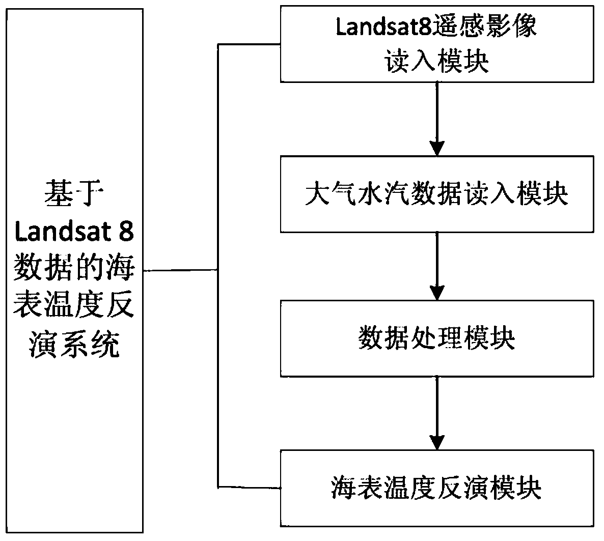
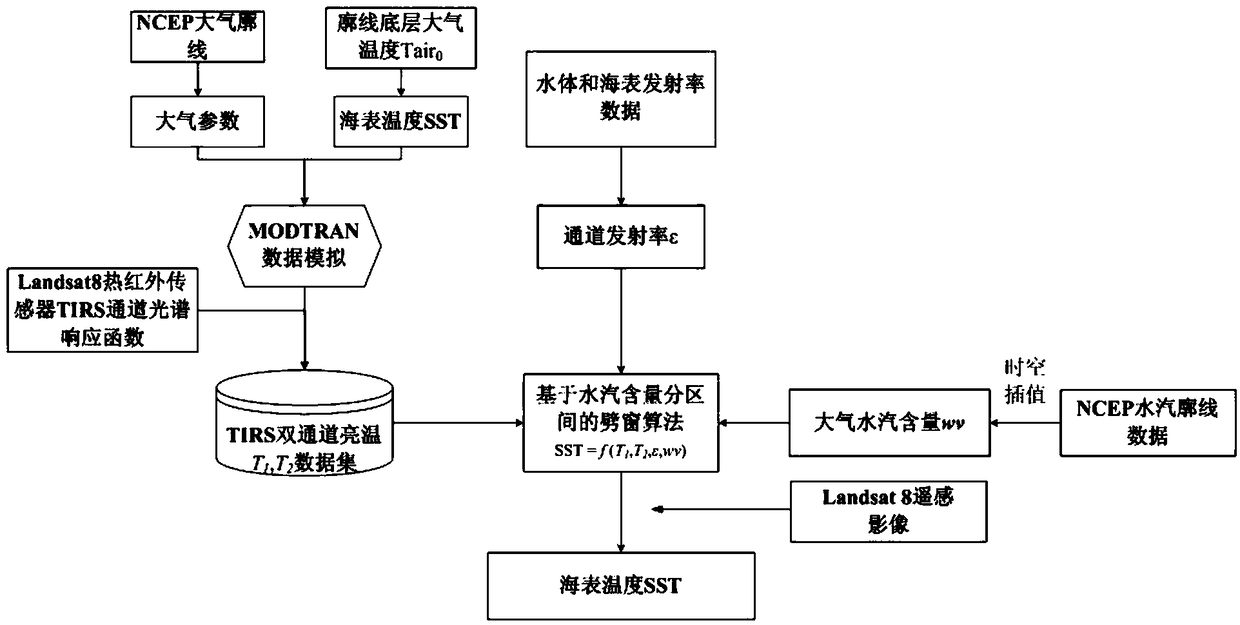
[0045] figure 1 It is a schematic diagram of the system structure of a preferred embodiment of the present invention. The sea surface temperature retrieval system based on Landsat 8 thermal infrared data includes Landsat8 remote sensing image reading module, atmospheric water vapor data reading module, data processing module and sea surface temperature retrieval module; the remote sensing image read-in module reads in Landsat 8 optical and thermal infrared remote sensing images, and sends them to the data processing module; the atmospheric water vapor data set read-in module reads in the NCEP atmosphere corresponding to the Landsat 8 image The profile data is sent to the data processing module; the data proce...


PUM


Abstract

The invention relates to an SST inversion method and system based on Landsat 8 data. The method comprises that Landsat 8 optical and thermal-infrared remote sensing images and corresponding atmospheric contour data are read; on the basis of water-body and seawater emissivity data and a spectral response function of a Landsat 8 TIRS (Thermal Infrared Sensor), the atmospheric contour is used for driving, and channel brightness temperatures in the aerosphere top of two channels of the TIRS under different combined conditions of atmospheric conditions, SSTs and emissivities are simulated; and the obtained total atmospheric column water vapor content is used to divide the atmospheric column water vapor content into intervals, a split-window algorithm is used to construct SST inversion algorithms of the different water vapor content intervals, the SST is calculated, and a result is output. The system comprises a remote-sensing image reading module, an atmospheric water vapor data reading data, a data processing module and an SST inversion module. The system and method can be used to obtain high-precision SST.

Description

technical field [0001] The present invention relates to the technical field of remote sensing thermal infrared, and more specifically relates to a sea surface temperature inversion method and system based on Landsat 8 data. Background technique [0002] Sea surface temperature (SST) is the direct driving force for long-wave radiation and turbulent flux exchange on the sea surface. Sea surface temperature represents the thermal radiation information and temporal and spatial changes of the sea surface in different states. As an important basic parameter, it has been widely used in various fields, including global climate change, large-scale energy balance, atmospheric circulation, sea surface Thermal anomalies, glacier melting, etc. [0003] Due to the complexity and diversity of the ocean surface, sea surface temperature often has significant changes over time and space. With the increasing demand for sea surface temperature products with temporal and spatial continuity in ...

Claims


Application Information

Patent Timeline
Patent Type & Authority Patents(China)
IPC IPC(8): G01J5/58
Inventor 秦其明任华忠杜宸何连孟晋杰
Owner PEKING UNIV
Learn More