
Construction method of engineering geological section map

A technology of engineering geology and construction method, applied in the field of geological survey technology in Ming Dynasty, can solve the problem of single display method of stratum model, and achieve the effect of improving the comprehensive disaster prevention and anti-destruction ability of the city, improving the unified display and improving the efficiency.

Inactive Publication Date: 2017-05-24
天津市勘察设计院集团有限公司 +1
View PDF3 Cites 9 Cited by
  • Summary
  • Abstract
  • Description
  • Claims
  • Application Information

AI Technical Summary

Problems solved by technology

It solves the problem of a single display mode of the current formation model, and improves the level of unified display, management and analysis of formation information

Method used


Image

  • Construction method of engineering geological section map
  • Construction method of engineering geological section map
  • Construction method of engineering geological section map

Examples


Embodiment 1

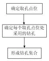
[0056] figure 1 The schematic flow diagram of the method for constructing the engineering geological section diagram provided in this embodiment, such as figure 1 As shown, the method follows the steps:

[0057] A method for constructing an engineering geological profile, characterized in that it comprises the following steps:

[0058] Determine the borehole used to construct the profile: obtain the borehole used to construct the profile, and construct the profile through the stratum information contained in the obtained borehole;

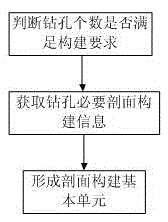
[0059] Organization of borehole data: Obtain the necessary profile construction information of each borehole in the borehole collection, organize the construction information in a structured manner, and form the basic unit of profile construction;

[0060] Stratum profile connection: connect the roof of the same stratum between adjacent boreholes with a solid line to represent the stratum;

[0061] Improvement of the auxiliary elements of the se...

Embodiment 2

[0107] Embodiment 2 has the same technical points as Embodiment 1, so the same parts will not be repeated here, please understand!

[0108] figure 1 The schematic flow diagram of the method for constructing the engineering geological section diagram provided in this embodiment, such as figure 1 As shown, the method follows the steps:

[0109] A method for constructing an engineering geological profile, characterized in that it comprises the following steps:

[0110] Determine the borehole used to construct the profile: obtain the borehole used to construct the profile, and construct the profile by obtaining the stratum information contained in the borehole;

[0111] Organization of borehole data: Obtain the necessary profile construction information of each borehole in the borehole collection, organize the construction information in a structured manner, and form the basic unit of profile construction;

[0112] Stratum profile connection: connect the roof of the same stratu...


PUM


Abstract

The invention discloses a construction method of an engineering geological profile, relating to the technical field of geological survey. The method is characterized by comprising the following steps of the determination of boreholes used by constructing a section map, borehole data organization, stratigraphic section line connection, and section map auxiliary element improvement. The method has the advantages that based on the preprocessing of data, a data mining method is used, and through the geological data seamless integration in the levels of syntax, semantic and model, the real-time updating is carried out, and the effective integration of multi-source data is realized. The method is applied to the expression of a survey result in a project is included and the expression of a survey result in design, analysis, construction related to geotechnical engineering is included. The method is applied to the expression of a survey result in the design, mining and recovery of an underground space is included, and the planning efficiency of a city underground space is improved.

Description

technical field [0001] The present invention relates to the technical field of geological survey, in particular to the realization of the construction of geological data models by visually displaying the conditions of underground strata, which can be applied to the field of engineering geology, the expression of engineering geological survey results, and the design, Analysis and expression of survey results in construction and energy and mineral related design, mining, and restoration of survey results, improve the efficiency of urban underground space planning, and guide the construction of engineering geological profiles for mineral resources and engineering geological exploration. Background technique [0002] A stratigraphic model (pattern) is a simplified expression and comprehensive interpretation of the composition, structure, and spatiotemporal existence of stratigraphic entities. The most common stratigraphic model is a section model in which the composition, stru...

Claims


Application Information

Patent Timeline
Patent Type & Authority Applications(China)
IPC IPC(8): G06T17/05
CPCG06T17/05
Inventor 熊鑫王永杰江贻芳韩晓晖沈迎志王国飞王静
Owner 天津市勘察设计院集团有限公司
Learn More