Mass three-dimensional digital city model organization and management method
A three-dimensional digital and city model technology, applied in image data processing, 3D modeling, instruments, etc., can solve the problem that the original data cannot ensure data consistency in later data, achieve fast loading efficiency, ensure consistency, and avoid inconsistency Effect
- Summary
- Abstract
- Description
- Claims
- Application Information
AI Technical Summary
Problems solved by technology
Method used
Image


Examples
Embodiment 1
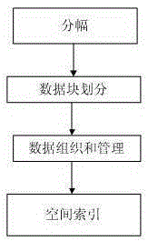
[0036] figure 1 A schematic flow diagram of a method for organizing and managing a massive 3D digital city model provided in this embodiment, as shown in figure 1 As shown, the method follows the steps:
[0037] Framing: According to the fragmentation range of large-scale topographic maps of the city, the original data is produced, updated and archived with the map as a unit;
[0038] Data block division: divide the city range into data blocks, and make all data block files smaller than a certain threshold;
[0039] Data organization and management: establish a spatial data index structure for data organization and management, and each node record contains the external cube of the node;
[0040] Spatial index: carry out spatial index on the 3D spatial data nodes, and judge whether the node cube meets the display requirements of the current viewing angle and distance.
[0041] In a specific embodiment, the framing: according to the framing range of the large-scale topographi...
Embodiment 2
[0056] figure 2 A schematic flow diagram of a method for organizing and managing a massive 3D digital city model provided in this embodiment, as shown in figure 2 As shown, the method follows the steps:
[0057] Framing: According to the fragmentation range of large-scale topographic maps of the city, the original data is produced, updated and archived with the map as a unit;
[0058] Data block division: divide the city range into data blocks, and make all data block files smaller than a certain threshold;
[0059] Data organization and management: establish a spatial data index structure for data organization and management, and each node record contains the external cube of the node;
[0060] Spatial index: carry out spatial index on the 3D spatial data nodes, and judge whether the node cube meets the display requirements of the current viewing angle and distance;
[0061] Data update: Automated tools are used to cut and encode data and update quadtrees.
[0062] In a...
PUM
 Abstract
Description
Claims
Application Information
 - R&D
- Intellectual Property
- Life Sciences
- Materials
- Tech Scout
- Unparalleled Data Quality
- Higher Quality Content
- 60% Fewer Hallucinations
Browse by: Latest US Patents, China's latest patents, Technical Efficacy Thesaurus, Application Domain, Technology Topic, Popular Technical Reports.
© 2025 PatSnap. All rights reserved.Legal|Privacy policy|Modern Slavery Act Transparency Statement|Sitemap|About US| Contact US: help@patsnap.com