Eureka AIR delivers breakthrough ideas for toughest innovation challenges, trusted by R&D personnel around the world.

High-precision three-dimensional real scene indoor and outdoor integrated positioning method and device

A positioning method and high-precision technology, which is applied in the field of communication, navigation, positioning and location services, can solve the problems of not being able to display the specific details of buildings, not being able to locate indoors, and the positioning accuracy cannot meet high standards, etc.

Inactive Publication Date: 2017-05-10
EAST CHINA NORMAL UNIV
View PDF2 Cites 74 Cited by
  • Summary
  • Abstract
  • Description
  • Claims
  • Application Information

AI Technical Summary

Problems solved by technology

However, the existing UWB indoor positioning system still has the following technical defects: 1) The positioning accuracy still cannot reach a high standard; 2) The positioning results are presented on a two-dimensional map, which cannot show the specific details of the actual building interior
However, although the collected point cloud data contains the position information of each point in the room, these position information are all position coordinates in the scanner coordinate system, which cannot be practically applied to indoor positioning.

Method used


Image

  • High-precision three-dimensional real scene indoor and outdoor integrated positioning method and device
  • High-precision three-dimensional real scene indoor and outdoor integrated positioning method and device
  • High-precision three-dimensional real scene indoor and outdoor integrated positioning method and device

Examples


Embodiment Construction

[0051] The present invention will be further described below in conjunction with the accompanying drawings.

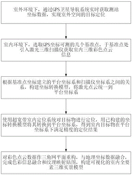
[0052] refer to figure 1 , the method steps of the present invention are as follows:

[0053] Step S10: In the outdoor environment, obtain the carrier phase data of the station in real time through the carrier phase difference technology of the GPS satellite navigation system, calculate the difference and solve the coordinates to realize the positioning of the outdoor space, and output the GPS satellite navigation signal positioning result;

[0054] Step S11: In the indoor environment, first select several reference points indoors where the GPS coordinates can be measured, and place a GPS receiver at the reference points; use a laser 3D scanner to scan the surface of the indoor scene at the reference points, and take the scanning points as The coordinate origin establishes the scanner coordinate system, obtains the three-dimensional coordinate information of the indoo...


PUM


Abstract

The invention discloses a high-precision three-dimensional real scene indoor and outdoor integrated positioning method and device. The method comprises the steps that the GPS positioning result is introduced to the indoor, multiple reference points of which the GPS coordinates are measurable are selected in the indoor, and a platform coordinate system is established with the reference points acting as the origins of coordinates; a laser three-dimensional scanner is introduced to the reference points so that indoor three-dimensional point cloud information is acquired, and high-precision indoor scene reconstruction is completed; an optimized coordinate transformation model is constructed according to the relationship between the platform coordinate system and a scanner coordinate system to unify the point cloud to the platform coordinate system; and coordinate transformation is further performed on an ultra-wideband indoor positioning system coordinate system and the coordinate data so that indoor target positioning is completed. The beneficial effects of the positioning method and device are that the point cloud data are introduced on the basis of the indoor positioning system, the high-precision visual indoor three-dimensional scene with geodetic coordinates is obtained by using the optimized coordinate transformation model, and the indoor positioning precision can be the decimeter level; and integration of indoor and outdoor positioning can be realized, and a browsable spatial information management system is provided.

Description

technical field [0001] The invention relates to the technical field of communication navigation positioning and location services, in particular to a three-dimensional real scene indoor and outdoor integrated positioning method based on a three-dimensional laser scanner and GPS signals, which is beneficial to improving indoor positioning accuracy and realizing indoor three-dimensional real scene visualization. Background technique [0002] The traditional outdoor positioning system is based on satellite positioning. At present, the widely used satellite positioning systems mainly include the GPS system, the Beidou satellite navigation system independently developed by my country, and the Russian GLONASS system. In the outdoor satellite positioning system, the GNSS receiver module receives signals from more than four satellites, and realizes terminal positioning through pseudo-range positioning or carrier phase. However, positioning systems such as Beidou and GPS use the pri...

Claims


Application Information

Patent Timeline
Patent Type & Authority Applications(China)
IPC IPC(8): G01S19/43G01C21/20
CPCG01S19/43G01C21/206
Inventor 姚瑶张雷郑正奇
Owner EAST CHINA NORMAL UNIV
Why Eureka
Eureka Blog
Learn More