Method for determining local optimal route of ship navigation by aiming at convex obstacles
A local optimal path and ship technology, applied in the field of safe navigation of ship routes, can solve the problems of reducing the efficiency of finding the optimal path and increasing the calculation amount of finding the optimal path.
- Summary
- Abstract
- Description
- Claims
- Application Information
AI Technical Summary
Problems solved by technology
Method used
Image
Examples
Embodiment 1
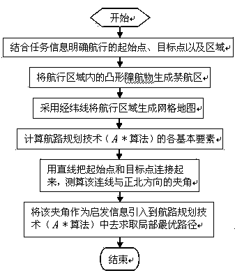
[0058] like figure 1 To such as Figure 4 As shown, assuming that the optimization target is the flight time, the specific realization of the present invention includes the following steps:
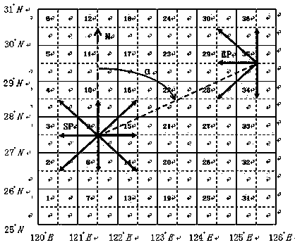
[0059] Step 1: If figure 2 As shown, first, the starting point SP (121.5°E, 27.5°N) and the target point EP (125.5°E, 29.5°N) of the voyage are clarified in combination with the task information, and the navigation area (longitude : 120°E~126°E, latitude: 25°N~31°N).
[0060] Step 2: Generate a no-navigation area from the convex obstacles (including static obstacles and dynamic obstacles) in the navigation area.
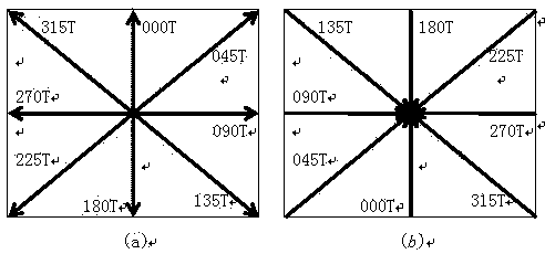
[0061] Step 3: If figure 2 As shown in , the navigation area is gridded with latitude and longitude of 1 degree * 1 degree specification to generate a grid map. A total of 36 grids (grid lines are solid lines) are obtained, and the center of each grid is a waypoint (the dotted line is to illustrate the position of the waypoint, and the intersection of the dotted lines in ...
PUM
 Abstract
Description
Claims
Application Information
 - Generate Ideas
- Intellectual Property
- Life Sciences
- Materials
- Tech Scout
- Unparalleled Data Quality
- Higher Quality Content
- 60% Fewer Hallucinations
Browse by: Latest US Patents, China's latest patents, Technical Efficacy Thesaurus, Application Domain, Technology Topic, Popular Technical Reports.
© 2025 PatSnap. All rights reserved.Legal|Privacy policy|Modern Slavery Act Transparency Statement|Sitemap|About US| Contact US: help@patsnap.com


