
Virtual-seed-point-based airborne LiDAR ground point cloud filter method

A technology of seed points and ground points, which is applied in the field of airborne LiDAR ground point cloud filtering based on virtual seed points, can solve the problems of progressive triangulation, such as time-consuming, low filtering precision, and high operating efficiency, to reduce the number of point clouds, Improved optimization and improved performance

Active Publication Date: 2016-11-23
NANJING UNIV
View PDF5 Cites 28 Cited by
  • Summary
  • Abstract
  • Description
  • Claims
  • Application Information

AI Technical Summary

Problems solved by technology

[0005] Aiming at the existing technology, progressive triangulation is time-consuming and it is difficult to quickly process point cloud data, but the filtering accuracy is high. When the multi-scale morphology is complex, the filtering accuracy is low, but the operating efficiency is high.

Method used


Image

  • Virtual-seed-point-based airborne LiDAR ground point cloud filter method
  • Virtual-seed-point-based airborne LiDAR ground point cloud filter method
  • Virtual-seed-point-based airborne LiDAR ground point cloud filter method

Examples


Embodiment Construction

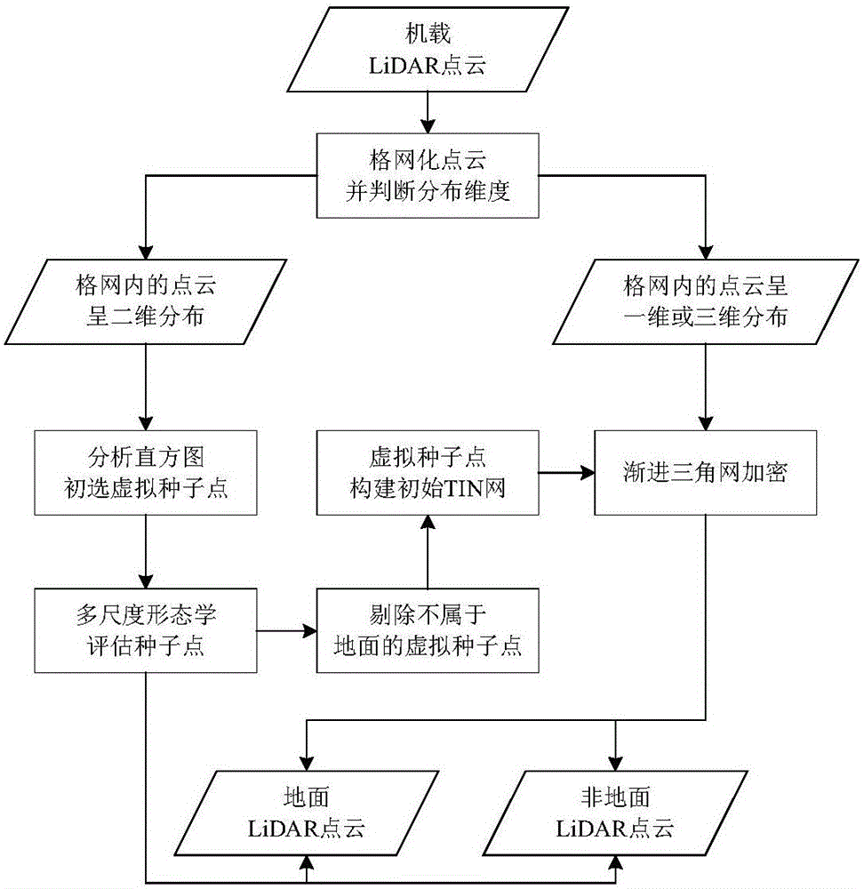
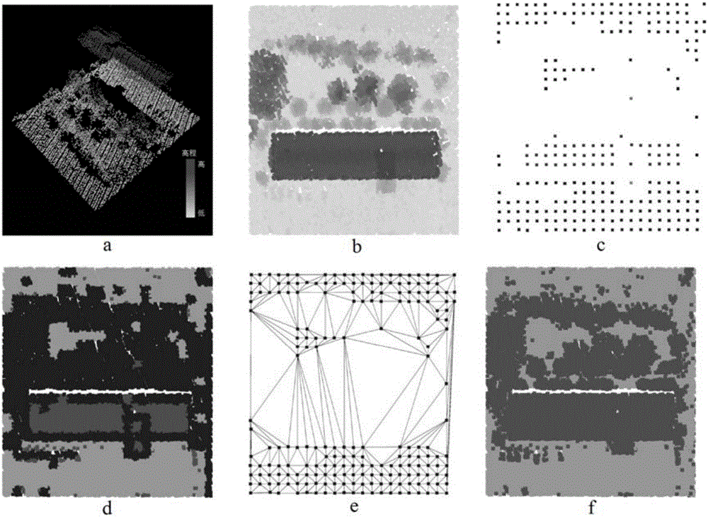
[0039] This embodiment adopts figure 2 The LiDAR point cloud data shown in a is used as the initial point cloud data for ground point cloud filtering and recognition. The data was collected by the Optech ALTM Gemini system in November 2009, and the point cloud density is about 3.62 points / m 2 . The image size of the example area is 68.16m×74.59m. The concrete implementation of this example adopts MATLAB and TerraSolid to realize. The specific flow chart is as figure 1 , the implementation steps are as follows:

[0040] Step 1: Obtain the LiDAR point cloud data describing the surface through the airborne LiDAR system, divide the LiDAR point cloud data on the XY plane with a two-dimensional grid, and obtain the grid set GridSet (such as figure 2 as shown in b);

[0041] That is, use MATLAB to create a four-dimensional array Dataset to read LiDAR point cloud data, and the category of the initialization point is 3 (representing the point to be determined). According to the...


PUM


Abstract

The invention, which belongs to the airborne LiDAR ground point cloud data classification field, discloses a virtual-seed-point-based airborne LiDAR ground point cloud filter method. The method comprises: grid transformation is carried out on an airborne LiDAR ground point and ground virtual seed points are constructed by using distribution dimensionality of point clouds in a grid and an elevation distribution histogram; virtual seed point evaluation is carried out by using the multi-scale morphology, a virtual seed point does not belong to the ground is rejected, and preliminary filtering is carried out on the point cloud; and an initial TIN network is constructed by using the evaluated virtual seed point and iterative encryption is carried out on the TIN network to complete ground point cloud filtering of LiDAR data. Therefore, the time spent in the filter algorithm is reduced and the filter precision of the filter algorithm is guaranteed; and the application range is wide.

Description

technical field [0001] The invention relates to an airborne LiDAR point cloud data classification method, in particular to an airborne LiDAR ground point cloud filtering method based on virtual seed points. Background technique [0002] Airborne LiDAR technology (Light Detection And Ranging, referred to as LiDAR), as a rapidly developing new detection method, can directly obtain the three-dimensional coordinates of the target, and has the advantages of strong initiative, high detection accuracy, and short operation cycle. This technology can be used in digital ground model extraction, building modeling, vegetation parameter estimation, power line extraction and many other fields. In the specific application process, the most important data processing step is the separation of ground points and non-ground points, that is, ground point cloud filtering of LiDAR data (hereinafter referred to as point cloud filtering). The amount of LiDAR data is large, and manual classification...

Claims


Application Information

Patent Timeline
IPC IPC(8): G06T7/00G06T17/30
CPCG06T17/30G06T2207/20024G06T2207/10044
Inventor 陈焱明刘小强杨康李开元程亮李满春邓树林张峰琦张宪哲陈东
Owner NANJING UNIV
Learn More