Method and system for intelligent drawing of industrial map regions and spots

An area and map technology, applied in the field of intelligent drawing methods and systems for industrial map areas, can solve problems such as wasting manpower and material resources, customers cannot provide project geographic coordinate data, and cannot obtain coordinate location information, etc., to improve accuracy and save money. Effects of data processing work

Active Publication Date: 2019-05-17
TAIHUA WISDOM IND GRP CO LTD
View PDF5 Cites 0 Cited by
  • Summary
  • Abstract
  • Description
  • Claims
  • Application Information

AI Technical Summary

Problems solved by technology

[0002] When designing an industrial map, the required industrial map data is provided by the customer, but most customers cannot provide the exact geographic coordinate data of the project, and only know the text description of the general location of the project; after converting the text description provided by the customer into In the case of coordinate data, since it is impossible to obtain accurate coordinate position information, it is necessary to manually find and enter the coordinate information, which wastes a lot of manpower and material resources

Method used


Image

  • Method and system for intelligent drawing of industrial map regions and spots

Examples


Embodiment Construction

[0032] The present invention will be further described below in conjunction with the accompanying drawings and embodiments.

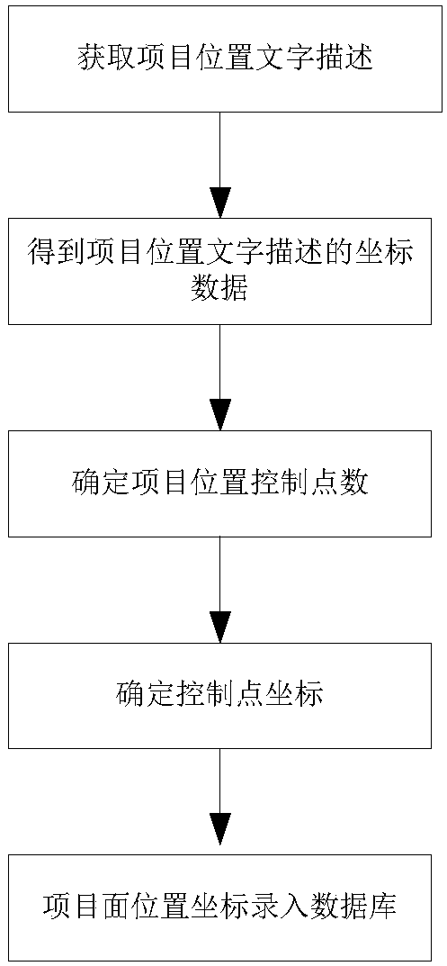
[0033] A method for intelligently drawing industrial map regions, such as figure 1 As shown, referring to the geocoding and inverse geocoding technology of the current web map, the location information of the center point of the project is automatically obtained according to the text description, and then according to the area of ​​the project, combined with two sets of data, the number of control points of the project is set to generate the planar location of the project Information data, stored in the database.

[0034] Specifically include the following steps:

[0035] (1) Obtain a textual description of the location of the project and information on the shape and area of ​​the location of the project;

[0036] (2) Obtain the project center point coordinate data information described in the text description of the project position through the inver...


PUM


Abstract

The invention discloses a method and system for intelligently drawing industrial map areas and spots, comprising: acquiring textual descriptions of project locations and shape and area information of project locations; and obtaining the textual descriptions of project locations through inverse geocoding technology of network maps coordinate data information; determine the shape of the project location, and set the number of control points for the project location according to the project shape; determine the coordinates of the control points according to the project shape and project area; obtain the project's planar coordinate location data, and enter it into the database. Beneficial effects of the present invention: According to the text description information of the project location provided by the user, the planar location coordinate data of the project can be obtained, and the data entry adopts an automatic method, which saves a lot of data processing work.

Description

technical field [0001] The invention relates to the technical field of industrial maps, in particular to a method and system for intelligently drawing industrial map areas and spots. Background technique [0002] When designing an industrial map, the required industrial map data is provided by the customer, but most customers cannot provide the exact geographic coordinate data of the project, and only know the text description of the general location of the project; after converting the text description provided by the customer into In the case of coordinate data, since accurate coordinate position information cannot be obtained, it is necessary to manually search and locate and enter the coordinate information, which wastes a lot of manpower and material resources. Contents of the invention [0003] The purpose of the present invention is to overcome the deficiencies of the above-mentioned prior art, and provide a method and system for intelligently drawing industrial map...

Claims


Application Information

Patent Timeline
Patent Type & Authority Patents(China)
IPC IPC(8): G06F16/29
CPCG06F16/29
Inventor 刘秀广李萍张同义马述杰刘治国王国松赵恒胜庄同光
Owner TAIHUA WISDOM IND GRP CO LTD
Why Eureka
Try Eureka