Intelligent reporting method and system for map spots of industry map area

An industrial and regional technology, applied in the field of intelligent reporting method and system of industrial map areas and spots, can solve the problems that customers cannot provide project geographic coordinate data, have no location information, and cannot obtain coordinate location information, etc., so as to save data processing work Effect

Inactive Publication Date: 2016-12-07
TAIHUA WISDOM IND GRP CO LTD
View PDF3 Cites 2 Cited by
  • Summary
  • Abstract
  • Description
  • Claims
  • Application Information

AI Technical Summary

Problems solved by technology

[0002] When designing an industrial map, the required industrial map data is provided by the customer, but most of the customers cannot provide the exact geographic coordinate data of the project, or even have no location information, only know the general location of the project; when using the data provided by the customer When converting to coordinate data, since it is impossible to obtain accurate coordinate position information, it is necessary to manually search and enter the coordinate information, which wastes a lot of manpower and material resources

Method used


Image

  • Intelligent reporting method and system for map spots of industry map area

Examples


Embodiment Construction

[0024] The present invention will be further described below in conjunction with the accompanying drawings and embodiments.

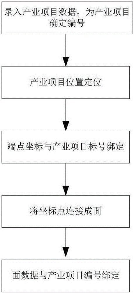
[0025] A method for intelligent reporting of industrial map areas, such as figure 1 shown, including:

[0026] (1) Enter the industrial project data provided by the customer into the database uniformly, and assign an ID number to each industrial project;

[0027] (2) Positioning of the industrial project: Determine the actual location of the industrial project according to the map system, and collect the coordinate information of each vertex on the boundary of the area where the industrial project is located. If the boundary of the area is irregular, collect as many point coordinates as possible The information shows its shape characteristics; the coordinates of the positioning are transmitted to the server and can be stored automatically.

[0028] Since the geographical location of the project is known, the location of the project is realized through...


PUM


Abstract

The invention discloses an intelligent reporting method and system for map spots of an industry map area. The method comprises the steps of inputting industry project data provided by clients into a database in a unified way and allocating an ID number to each industry project; locating the position of the industry project; binding acquired coordinate position information with the number of the industry project, and storing coordinate position information of each end point; selecting coordinates of one end point in an area where the industry project is located as an initial point, sequentially connecting all end points of a boundary of the area according to a set sequence along the boundary of the area, finally returning to the initial point for ending the process, and connecting the points to form a surface; and binding obtained surface data with the number of the industry project, and performing storage to obtain data information of the map spots of the industry map area. The method and the system have the beneficial effects that the system automatically uploads data update or edits geographic information of the industry project, and an automated data input mode is adopted, so that a large amount of data processing work is reduced.

Description

technical field [0001] The invention relates to the technical field of industrial maps, in particular to a method and system for intelligent reporting of industrial map areas and spots. Background technique [0002] When designing an industrial map, the required industrial map data is provided by the customer, but most of the customers cannot provide the exact geographic coordinate data of the project, or even have no location information, only know the general location of the project; when using the data provided by the customer When converting to coordinate data, since it is impossible to obtain accurate coordinate position information, it is necessary to manually search and enter the coordinate information, which wastes a lot of manpower and material resources. Contents of the invention [0003] The purpose of the present invention is to overcome the above-mentioned deficiencies in the prior art, and provide a method and system for intelligent reporting of industrial ma...

Claims


Application Information

Patent Timeline
Patent Type & Authority Applications(China)
IPC IPC(8): G06F17/30G06Q10/10
CPCG06F16/29G06Q10/103
Inventor 张同义周永利马述杰刘秀广韦晓
Owner TAIHUA WISDOM IND GRP CO LTD
Why Eureka
Try Eureka