A Single Temporal Full Coverage Retrieval Method for Remote Sensing Data Based on Spatial Secondary Filtering

A technology of remote sensing data and secondary filtering, which is applied in the field of remote sensing applications and can solve problems such as low efficiency and omissions

Active Publication Date: 2020-02-07
北京四维新世纪信息技术有限公司
View PDF2 Cites 0 Cited by
  • Summary
  • Abstract
  • Description
  • Claims
  • Application Information

AI Technical Summary

Problems solved by technology

The traditional method is to manually select and combine remote sensing images that meet the requirements. In the context of the current massive remote sensing data, not only is the efficiency extremely low, but it is also easy to cause problems such as omissions.

Method used


Image

  • A Single Temporal Full Coverage Retrieval Method for Remote Sensing Data Based on Spatial Secondary Filtering
  • A Single Temporal Full Coverage Retrieval Method for Remote Sensing Data Based on Spatial Secondary Filtering
  • A Single Temporal Full Coverage Retrieval Method for Remote Sensing Data Based on Spatial Secondary Filtering

Examples


Embodiment Construction

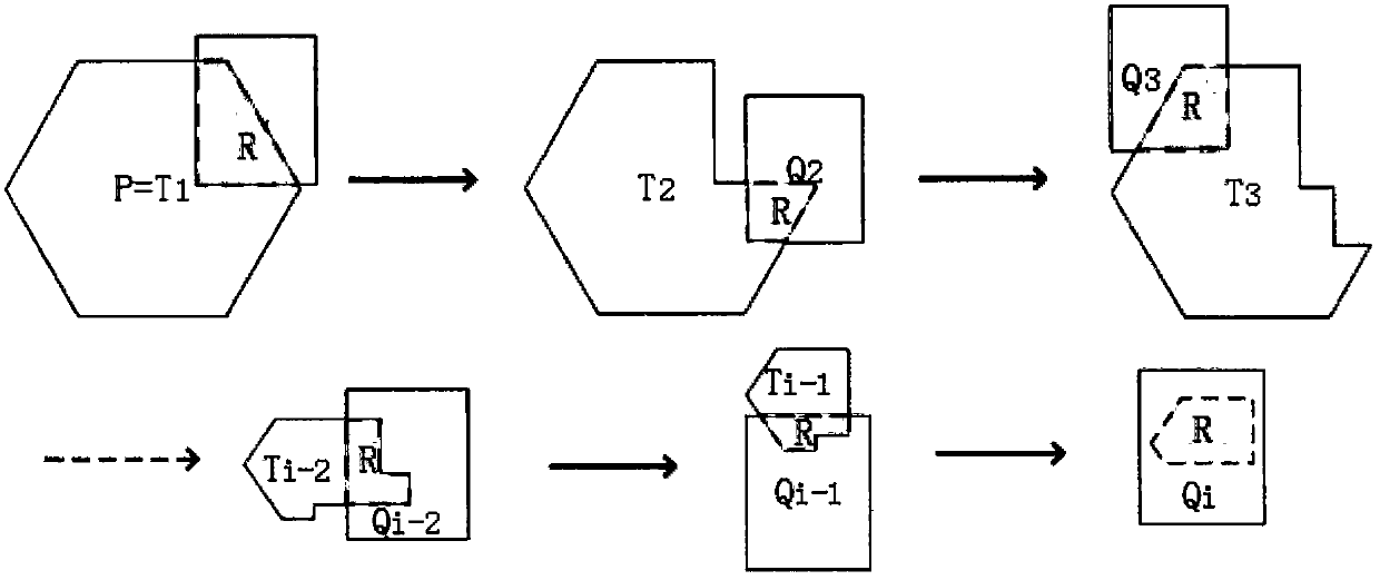
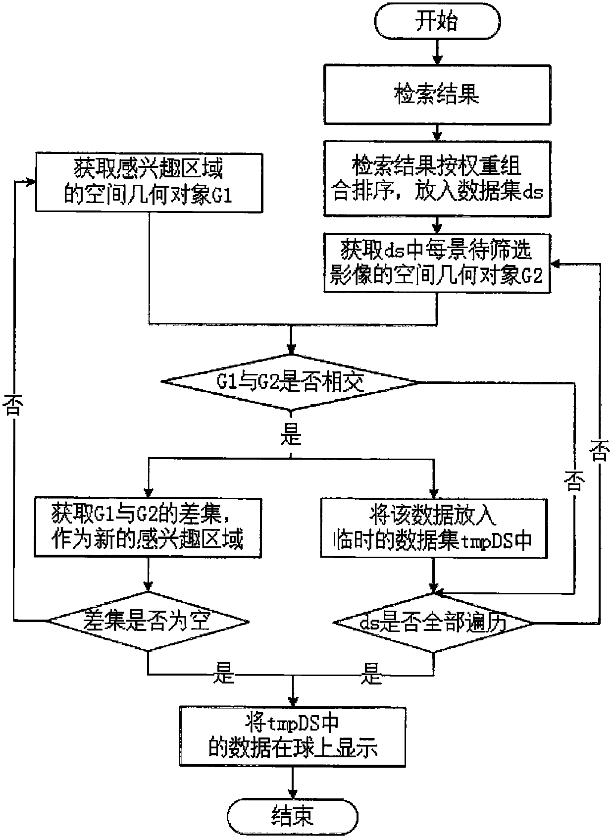
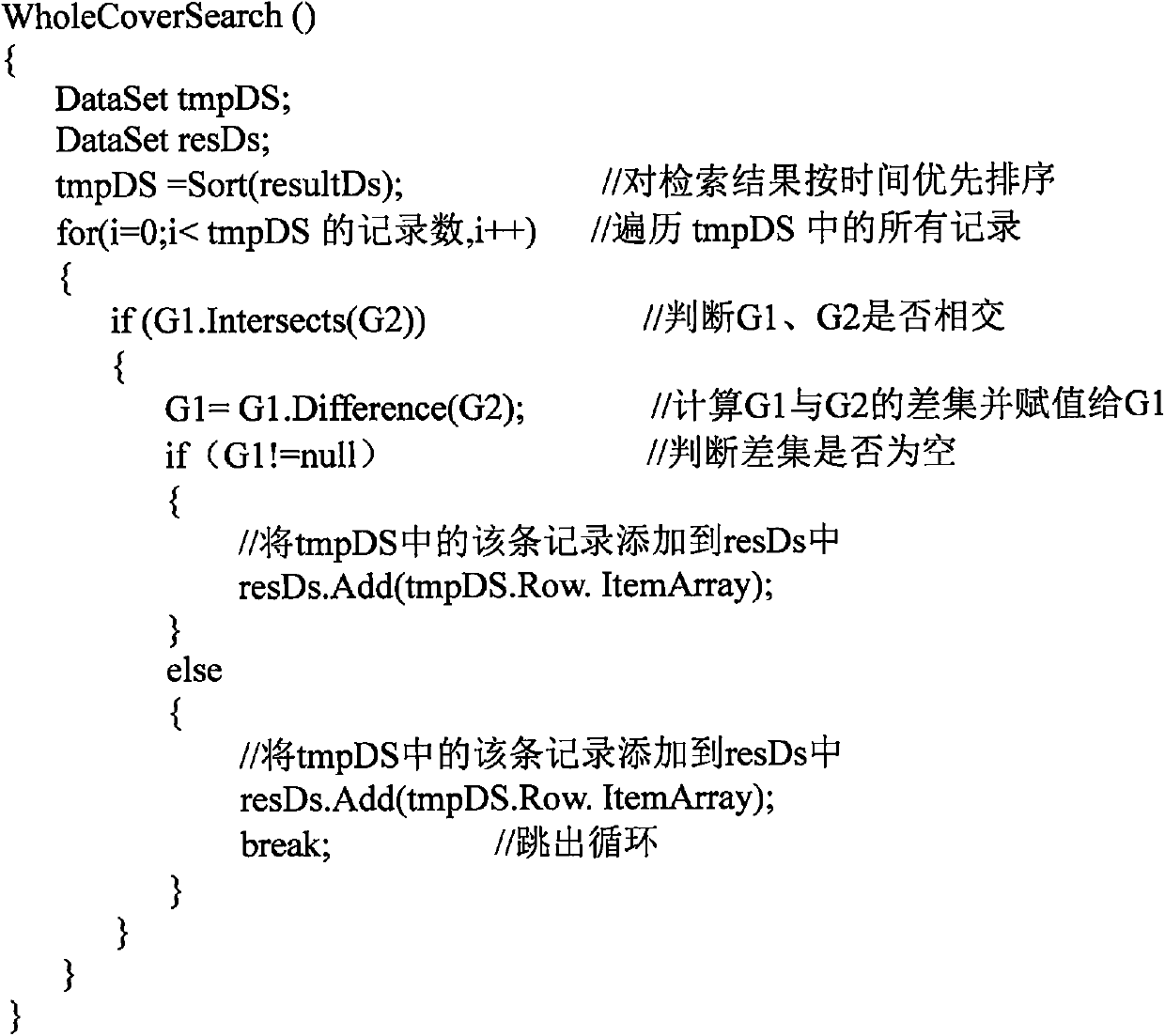
[0012] For a given region of interest, find all the remote sensing image data that meet the conditions, perform weight combination and sorting on them, judge the spatial geometric relationship between the spatial geometric objects of each image and the region of interest, and find out the region of interest and the image in a loop The difference set of spatial geometric objects is filtered twice, so that the remote sensing data with single-temporal full coverage can be obtained quickly and accurately. The principle of this method is specifically: assuming that the spatial geometric object of the region of interest is any polygon P, and the spatial geometric object of the image to be screened is a polygon Qi (0}. When the difference set between Ti and Qi is empty, it means that P has been segmented, that is, the region of interest is fully covered, and the set Qi (Qi∩Ti!=NULL) is the result set of a single-temporal full coverage, such as figure 1 shown.

[0013] The concrete i...


PUM


Abstract

The invention discloses a single-time-phase full-coverage retrieval method based on space secondary filtering. According to requirements, all retrieved image data is subjected to weight combined sorting, and the space information of a remote sensing image and an area of interest is subjected to space secondary filtering screening to obtain the single-time-phase full-coverage remote sensing image data of the area of interest. By use of the method, a single-time-phase full-coverage remote sensing dataset can be automatically, efficiently and accurately screened from mass remote sensing data, and defects that traditional manual screening is low in efficiency, is likely to cause omissions and the like can be made up.

Description

technical field [0001] The invention relates to the field of remote sensing applications, in particular to a method for retrieving and screening massive remote sensing data. Background technique [0002] With the development of earth observation calculation, the amount of satellite remote sensing image data has reached PB level, and remote sensing technology has been widely used in many aspects in our country. Single-temporal full-coverage retrieval refers to the data combination screening of one-time full coverage of remote sensing data for a specific area, which is one of the main steps in the application of most massive remote sensing data. At present, various remote sensing data service platforms have been built at home and abroad, such as NASA LAADS WEB, GLCF, USGS and other remote sensing data download platforms abroad, and domestically include China Resources Satellite Application Center Data Service Platform, Geospatial Data Cloud, and Zhongke Remote Sensing Company ...

Claims


Application Information

Patent Timeline
Patent Type & Authority Patents(China)
IPC IPC(8): G06F16/50
CPCG06F16/50
Inventor 余涛黄祥志何方园周珂赵亚萌
Owner 北京四维新世纪信息技术有限公司
Why Eureka
Try Eureka