
Method for manufacturing and displaying urban center micro heat island digital map

A technology of digital map and display method, which is applied in the direction of electronic digital data processing, structured data retrieval, geographic information database, etc., can solve the problems of lack of query and expression methods, and does not take into account the influence of urban thermal environment, etc., to achieve rapid The effect of getting and accessing

Active Publication Date: 2016-08-17
SOUTHEAST UNIV
View PDF2 Cites 8 Cited by
  • Summary
  • Abstract
  • Description
  • Claims
  • Application Information

AI Technical Summary

Problems solved by technology

Existing technologies do not take into account the impact of various urban buildings and environmental spatial forms on the urban thermal environment
In addition, research on multi-dimensional and intuitive query and expression methods for information is also lacking.

Method used


Image

  • Method for manufacturing and displaying urban center micro heat island digital map
  • Method for manufacturing and displaying urban center micro heat island digital map
  • Method for manufacturing and displaying urban center micro heat island digital map

Examples


Embodiment Construction

[0039] The present invention will be further described below in conjunction with each accompanying drawing in the description of the accompanying drawings.

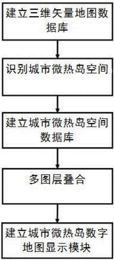
[0040] figure 1 A method for making and displaying a digital map of micro heat islands in urban centers, comprising the following steps:

[0041] 1) Establish a city three-dimensional vector map database;

[0042] 2) Identify the micro-heat island space in the city center;

[0043] 3) Establish a database on the thermal environment of micro-heat island space in the city center;

[0044] 4) Propose and establish different layers for the thermal environment measurement, thermal environment simulation analysis and urban spatial form of the micro heat island space thermal environment database in the city center;

[0045] 5) Establish a digital map display module of micro heat island in the city center, which is respectively connected with the three-dimensional vector map database and the micro heat island space thermal env...


PUM


Abstract

The invention discloses a method for manufacturing and displaying an urban center micro heat island digital map. The method comprises a step 1) of establishing an urban three-dimensional vector map database; a step 2) of identifying an urban center micro heat island space; a step 3) of establishing an urban center micro heat island space thermal environment database; a step 4) of putting forward and establishing different map layers according to thermal environment actual measurement, thermal environment simulation analysis and urban spatial form of the urban center micro heat island space thermal environment database; a step 5) of establishing an urban center micro heat island digital map display module, respectively connecting the urban center micro heat island digital map display module with the urban three-dimensional vector map database and the urban center micro heat island space thermal environment database, and outputting corresponding urban center micro heat island digital images and data through the urban center micro heat island digital map display module according to selected data information. The method for manufacturing and displaying the urban center micro heat island digital map is favorable for urban thermal environment and heat island effect and having an auxiliary effect on urban design and urban planning.

Description

technical field [0001] The invention relates to a method for making a digital map, and more particularly to a method for making and displaying a digital map of micro heat islands in the city center. Background technique [0002] In recent years, under the background of global warming and my country's rapid urbanization, the urban heat island effect has become more and more serious, which not only affects the living comfort and health of urban residents, but also may lead to various heat wave disasters. As one of the important indicators of urban ecological environment, urban thermal environment has attracted more and more people's attention, and the need to deal with the urban heat island problem in urban planning and design is also becoming more and more urgent. [0003] At present, remote sensing image technology is mostly used in the research of urban heat island effect at home and abroad. However, the three-dimensional space in the urban center area has various forms, an...

Claims


Application Information

Patent Timeline
IPC IPC(8): G06F17/30
CPCG06F16/29
Inventor 杨俊宴吴浩
Owner SOUTHEAST UNIV
Learn More