Inertial auxiliary GPS/BDS fusion large-scale measurement device and method for quickly measuring land parcel

An inertial assistance and measurement device technology, applied in the field of surveying, mapping and navigation, can solve problems such as navigation position deviation, and achieve the effect of improving reliability

Inactive Publication Date: 2016-05-04
韩厚增 +1
View PDF10 Cites 19 Cited by
  • Summary
  • Abstract
  • Description
  • Claims
  • Application Information

AI Technical Summary

Problems solved by technology

However, long-term navigation will cause position deviation, which needs to be corrected by external information

Method used


Image

  • Inertial auxiliary GPS/BDS fusion large-scale measurement device and method for quickly measuring land parcel
  • Inertial auxiliary GPS/BDS fusion large-scale measurement device and method for quickly measuring land parcel
  • Inertial auxiliary GPS/BDS fusion large-scale measurement device and method for quickly measuring land parcel

Examples


Embodiment Construction

[0083] The present invention will be described in detail below in conjunction with specific embodiments.

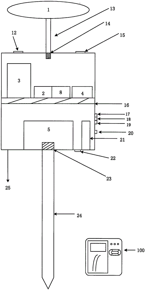
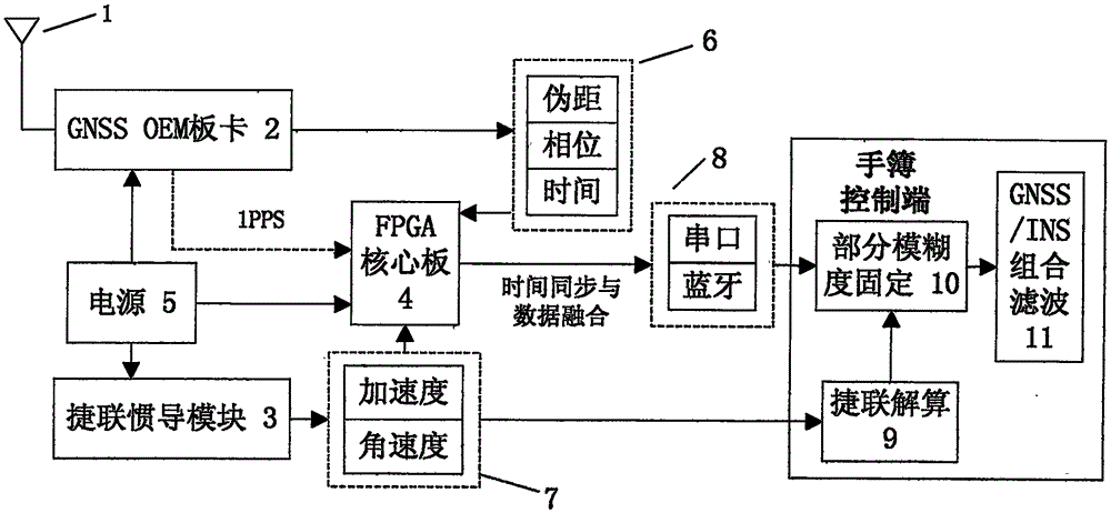
[0084] figure 1 It is a structural diagram of an inertial-assisted GPS / BDS fusion large-scale rapid parcel measurement device, including a strapdown inertial navigation module 3, a GNSSOEM board 2, a handbook control terminal 100, and an FPGA core board 4.

[0085]Strapdown inertial navigation module 3 is used to collect inertial measurement information, output inertial navigation observation data including acceleration and angular velocity to FPGA core board 4, GNSSOEM board 2 is used to complete the reception and processing of high-precision GNSS signals, and the output includes The GNSS observation data including pseudorange, phase, and time are sent to the FPGA core board 4; the FPGA core board 4 is used to calibrate the time of the inertial navigation data and perform data fusion of the GNSS observation data and the inertial navigation observation data; transmit thro...


PUM


Abstract

The invention discloses an inertial auxiliary GPS/BDS fusion large-scale measurement device and method for quickly measuring a land parcel. The inertial auxiliary GPS/BDS fusion large-scale measurement device for quickly measuring a land parcel comprises a strap-down inertial navigation module(3), a GNSS OEM board card (2), a handhold notebook control terminal(100) and a FPGA central board card (4); the land parcel measurement method integrates continuous satellite signal tracking and inertial navigation location output, and is based on second pulse signal to realize data synchronization and integration; carrier wave phase observed values are adopted for tight combination location resolving; inertial auxiliary GPS/BDS fusion ambiguity resolving is realized; and a partial ambiguity fixing strategy is adopted which helps increase the success rate of ambiguity fixing. By use of the method, the location precision and reliability of the system in shielding regions and half-shielding regions are substantially increased. The method can be applied in various land parcel on-site measurement environments and can increase the work efficiency of a land parcel measurement.

Description

technical field [0001] The invention relates to satellite positioning, inertial positioning and integrated navigation and positioning technology, in particular to an inertial-assisted GPS / BDS fusion large-scale rapid parcel measurement device and method, which belongs to the field of surveying and navigation technology, and is a parcel measurement method. Background technique [0002] With the rapid development of my country's national economy, the demand for location information in various industries is increasing, especially for large-scale topographic maps of urban areas, which are the basic data of land management and planning departments. Large-scale topographic maps have become indispensable for urban construction planning basic information. At present, there are no maps, lack of maps, and old maps in urban areas, which greatly restricts the spatial planning of urban areas. However, facing the urgent demand for 3D geographic information maps for urban regional spatial ...

Claims


Application Information

Patent Timeline
Patent Type & Authority Applications(China)
IPC IPC(8): G01S19/47G01S19/44
CPCG01S19/44G01S19/47
Inventor 韩厚增王坚
Owner 韩厚增
Why Eureka
Try Eureka