Traffic zone dividing method based on sparse vehicle license identification data

A technology for license plate recognition and traffic community, which is applied to the traffic control system of road vehicles, traffic flow detection, traffic control system, etc., and can solve the problems of inaccurate results, sparse traffic data, and limited number of intersections.

Active Publication Date: 2016-04-20
ZHEJIANG UNIV
View PDF9 Cites 17 Cited by
  • Summary
  • Abstract
  • Description
  • Claims
  • Application Information

AI Technical Summary

Problems solved by technology

However, due to financial and other issues, the number of intersections deployed with sensors is limited, and the obtained traffic data is very sparse, and the results obtained by using traditional division methods are often inaccurate

Method used


Image

  • Traffic zone dividing method based on sparse vehicle license identification data
  • Traffic zone dividing method based on sparse vehicle license identification data
  • Traffic zone dividing method based on sparse vehicle license identification data

Examples


Embodiment Construction

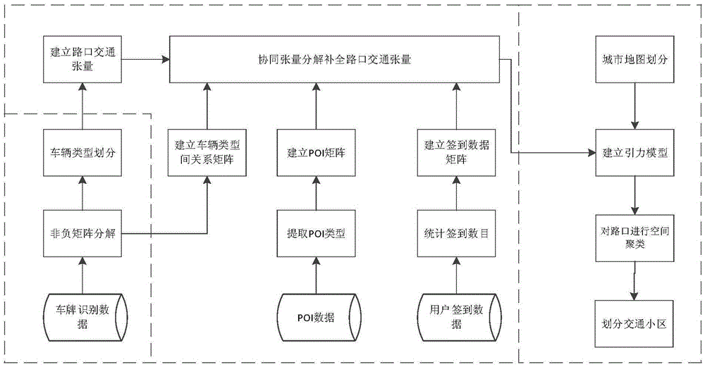
[0044] The present invention proposes a traffic area division method based on sparse license plate recognition data, the flow chart is as follows figure 1 As shown, it is divided into three stages: vehicle type identification, intersection data completion and traffic area division.

[0045] In the vehicle type identification stage, the vehicle travel types are mainly divided, and the correlation between vehicle types is obtained, so as to establish the intersection traffic condition tensor reflecting the travel time of different types of vehicles.

[0046] Due to the limited number of intersections equipped with traffic data sensors, the license plate recognition data is very sparse. Therefore, the data of intersections that are not equipped with sensors in this tensor is completed.

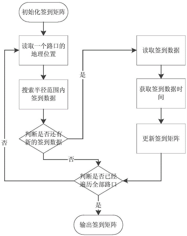
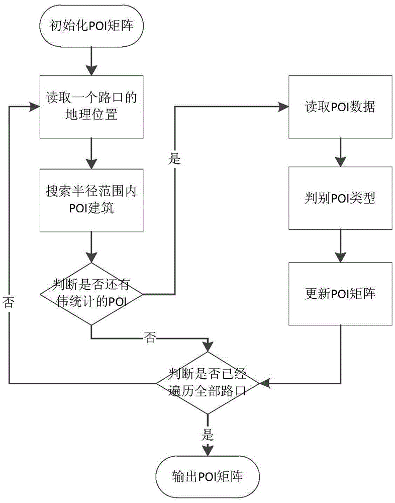
[0047] In the intersection data completion stage, the social media software user check-in data and geographic information POI data are mainly introduced, combined with the intersection traffic st...


PUM


Abstract

The invention discloses a traffic zone dividing method based on sparse vehicle license identification data. The traffic zone dividing method comprises steps of: analyzing vehicle travel characteristics at various intersections from the vehicle license identification data, determining travel vehicle types, and constructing tensors indicative of intersection traffic conditions; analyzing a correlation among the travel vehicle types, introducing map POI data and social media user signature data, and complementing the sparse intersection traffic tensors by using cooperative tensor decomposition; and performing spatial clustering on a map on the basis of the intersection traffic tensors in order to divide the map into different traffic zones. By dividing the traffic zones, the method may reflect urban traffic conditions in a more visualized way and provides help for urban planning.

Description

technical field [0001] The invention relates to the field of traffic district division in urban computing, in particular to a traffic district division method based on sparse license plate recognition data. Background technique [0002] With the development of society, future cities will bear more and more population pressure and traffic pressure. Solving the problems of urban development and building smart cities has become the mainstream of urbanization development. To alleviate urban traffic congestion, it is first necessary to have a clear understanding of the generation and distribution of urban traffic. However, the traffic conditions in the whole city are complicated. In order to enhance the practical operability of traffic survey, reduce the workload of traffic survey as much as possible, and reduce the difficulty of traffic analysis and forecasting, it is necessary to divide the traffic network of the whole city into reasonable traffic districts. A necessary step ...

Claims


Application Information

Patent Timeline
IPC IPC(8): G08G1/017G08G1/01G08G1/065G08G1/00
CPCG08G1/00G08G1/0116G08G1/012G08G1/0125G08G1/0137G08G1/017G08G1/065
Inventor 陈岭邵维
Owner ZHEJIANG UNIV
Why Eureka
Try Eureka