A Method for Edge Extraction of Airborne LiDAR Point Cloud Data

An airborne lidar, point cloud data technology, applied in computer parts, instruments, computing and other directions, can solve the problem that the edge of lidar point cloud data cannot be completely extracted, the point cloud data cannot be used effectively, and the loss of spatial geometric information, etc. problem, to achieve the effect of robust extraction, fewer parameters, and simplified complexity.

Inactive Publication Date: 2018-10-30
CHINESE ACAD OF SURVEYING & MAPPING
View PDF4 Cites 0 Cited by
  • Summary
  • Abstract
  • Description
  • Claims
  • Application Information

AI Technical Summary

Problems solved by technology

[0005] (2) Lidar point cloud data contains more spatial geometric information than two-dimensional images, and correspondingly, its corresponding geometric structure is more complex
[0006] (3) The point cloud data acquired by lidar is unorganized three-dimensional point cloud data, and its neighborhood structure is very complex and there are great differences due to different retrieval methods; however, the image is arranged in a regular grid, and the determination of the neighborhood is very difficult. easy
[0009] (1) The "indirect method" involves the transformation from 3D to 2D, resulting in the loss of a large amount of spatial geometric information
[0010] (2) The "direct method" has limited applicability and is only suitable for specific types of edge extraction
[0011] (3) These methods are only suitable for local small-scale noise-free point cloud data, and cannot be effective for large-area and noisy point cloud data
[0012] (4) The process of these methods is complex and the degree of automation is low. It needs preprocessing such as point cloud segmentation and target extraction, and then extracts the edge for a specific target.
[0013] Due to the constraints of the above deficiencies, at present, the edges in the lidar point cloud data cannot be completely extracted, and the degree of automation is low.

Method used


Image

  • A Method for Edge Extraction of Airborne LiDAR Point Cloud Data
  • A Method for Edge Extraction of Airborne LiDAR Point Cloud Data
  • A Method for Edge Extraction of Airborne LiDAR Point Cloud Data

Examples


Embodiment Construction

[0063] In order to clearly illustrate the technical characteristics of this solution, the following describes the present invention in detail through specific implementations and in conjunction with the accompanying drawings. The following disclosure provides many different embodiments or examples for implementing different structures of the present invention. In order to simplify the disclosure of the present invention, the components and settings of specific examples are described below. In addition, the present invention may repeat reference numbers and / or letters in different examples. This repetition is for the purpose of simplification and clarity, and does not in itself indicate the relationship between the various embodiments and / or settings discussed. It should be noted that the components illustrated in the drawings are not necessarily drawn to scale. The present invention omits descriptions of well-known components and processing techniques and processes to avoid u...


PUM


Abstract

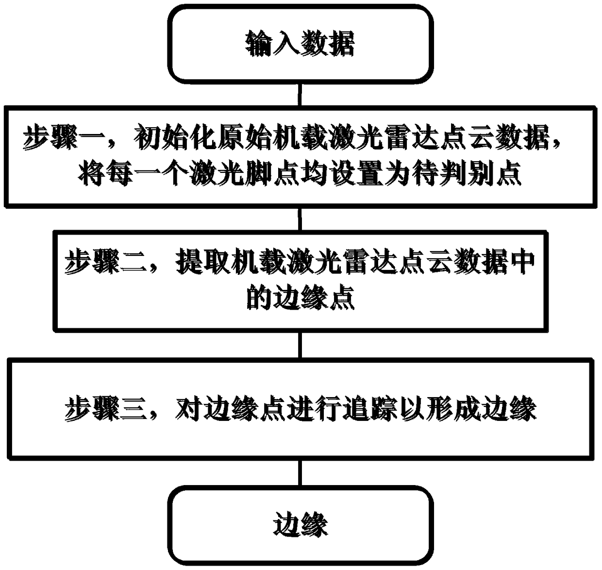
The invention discloses an edge extraction method of airborne laser radar point cloud data, which comprises the following steps: step 1, initializing the original airborne laser radar point cloud data, and setting each laser foot point as a point to be judged; step 2 , extract the edge points in the airborne lidar point cloud data; Step 3, track the edge points to form edges. The present invention does not need to rely on the optical image corresponding to the laser radar point cloud data, does not need to convert the laser radar point cloud data into a depth image, and directly extracts edges from the three-dimensional point cloud, effectively distinguishing each crossing edge, and effectively simplifying the complexity of the edge extraction algorithm The degree of automation of edge detection is improved, and all types of edges in the lidar point cloud can be effectively extracted.

Description

Technical field [0001] The invention relates to a feature extraction method, in particular to an edge extraction method of airborne lidar point cloud data, belonging to the technical field of lidar point cloud data information extraction. Background technique [0002] Feature extraction, as an important research field of image analysis and computer vision, has attracted the attention and research of many scholars. As an important part of these features, edges not only widely exist in two-dimensional images, but also exist in various scenes (especially urban scenes with a large number of artificial buildings) and three-dimensional point cloud data of individual features. Compared with point clouds, images are a more common type of data; in the past, due to the limitations of lidar sensor hardware, the detailed structure of the ground features in the past 3D point cloud data, especially the edges, are usually missing Or ambiguous. Therefore, most of the current edge detection met...

Claims


Application Information

Patent Timeline
Patent Type & Authority Patents(China)
IPC IPC(8): G06K9/46
CPCG06V10/44
Inventor 林祥国倪欢张继贤
Owner CHINESE ACAD OF SURVEYING & MAPPING
Why Eureka
Try Eureka